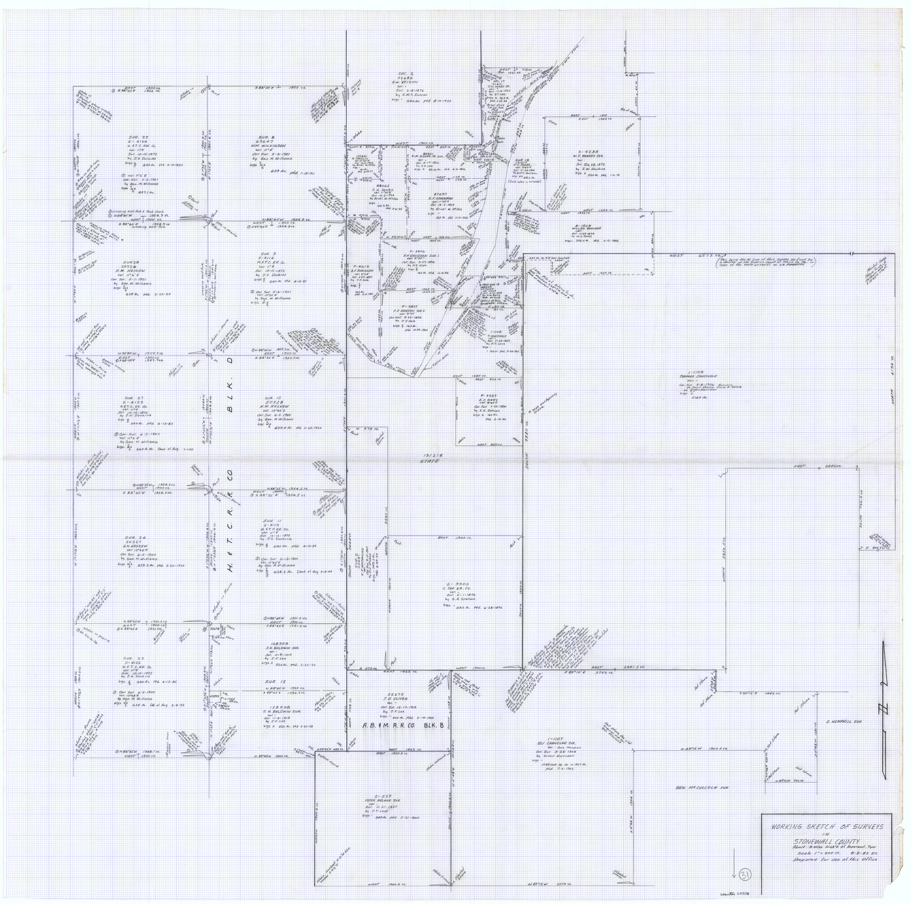
Stonewall County Working Sketch 31
-
Map/Doc
62338
-
Collection
General Map Collection
-
Object Dates
8/8/1983 (Creation Date)
-
People and Organizations
Elisandro Leos (Draftsman)
-
Counties
Stonewall
-
Subjects
Surveying Working Sketch
-
Height x Width
42.6 x 42.9 inches
108.2 x 109.0 cm
-
Scale
1" = 300 varas
Part of: General Map Collection
Reagan County Sketch File 21

Print $20.00
- Digital $50.00
Reagan County Sketch File 21
1939
Size 31.1 x 31.3 inches
Map/Doc 10585
Culberson County Working Sketch 33

Print $20.00
- Digital $50.00
Culberson County Working Sketch 33
1960
Size 26.9 x 34.1 inches
Map/Doc 68486
Andrews County Sketch File 5

Print $4.00
- Digital $50.00
Andrews County Sketch File 5
1936
Size 11.8 x 8.8 inches
Map/Doc 12823
Red River County Sketch File 3

Print $4.00
- Digital $50.00
Red River County Sketch File 3
Size 10.4 x 8.3 inches
Map/Doc 35098
Dawn on the Delta 74 Million Years Ago

Dawn on the Delta 74 Million Years Ago
1993
Size 20.6 x 27.3 inches
Map/Doc 96832
Jefferson County Rolled Sketch 4

Print $40.00
- Digital $50.00
Jefferson County Rolled Sketch 4
Size 36.7 x 65.3 inches
Map/Doc 9269
Throckmorton County Sketch File 3

Print $6.00
- Digital $50.00
Throckmorton County Sketch File 3
Size 10.4 x 10.2 inches
Map/Doc 38052
Kimble County Sketch File 19

Print $6.00
- Digital $50.00
Kimble County Sketch File 19
Size 9.9 x 15.0 inches
Map/Doc 28955
Map of Surveys Made for the T&PRR in Borden, Dawson, Howard & Martin Counties, Blocks 32, 33, 34, 35 & 36, Reserve West of the Colorado

Print $20.00
- Digital $50.00
Map of Surveys Made for the T&PRR in Borden, Dawson, Howard & Martin Counties, Blocks 32, 33, 34, 35 & 36, Reserve West of the Colorado
1876
Size 42.0 x 38.2 inches
Map/Doc 2231
Lipscomb County Sketch File 6

Print $20.00
- Digital $50.00
Lipscomb County Sketch File 6
1965
Size 19.4 x 26.1 inches
Map/Doc 12005
El Paso County Working Sketch 19

Print $20.00
- Digital $50.00
El Paso County Working Sketch 19
1960
Size 20.8 x 20.8 inches
Map/Doc 69041
Freestone County Working Sketch 31

Print $20.00
- Digital $50.00
Freestone County Working Sketch 31
1995
Size 42.8 x 33.9 inches
Map/Doc 78205
You may also like
McMullen County Working Sketch 1

Print $20.00
- Digital $50.00
McMullen County Working Sketch 1
1911
Size 20.9 x 13.1 inches
Map/Doc 70702
Aransas County Sketch File 5

Print $4.00
- Digital $50.00
Aransas County Sketch File 5
1850
Size 12.1 x 7.9 inches
Map/Doc 13108
[Texas Boundary Line]
![92070, [Texas Boundary Line], Twichell Survey Records](https://historictexasmaps.com/wmedia_w700/maps/92070-1.tif.jpg)
Print $20.00
- Digital $50.00
[Texas Boundary Line]
Size 21.5 x 12.0 inches
Map/Doc 92070
Ward County Working Sketch 26

Print $20.00
- Digital $50.00
Ward County Working Sketch 26
1964
Size 38.2 x 24.5 inches
Map/Doc 72332
Real County Working Sketch 65

Print $20.00
- Digital $50.00
Real County Working Sketch 65
1969
Size 31.1 x 23.4 inches
Map/Doc 71957
America's Fun-Tier: Texas 1966 Official State Highway Map

Digital $50.00
America's Fun-Tier: Texas 1966 Official State Highway Map
Size 28.0 x 36.2 inches
Map/Doc 94323
Terrell County Working Sketch 31

Print $20.00
- Digital $50.00
Terrell County Working Sketch 31
1945
Size 26.8 x 27.8 inches
Map/Doc 62123
Childress County Sketch File 15

Print $8.00
- Digital $50.00
Childress County Sketch File 15
Size 14.3 x 8.3 inches
Map/Doc 18278
Howard County Sketch File 10

Print $20.00
- Digital $50.00
Howard County Sketch File 10
Size 22.5 x 22.0 inches
Map/Doc 11798
Wise County Rolled Sketch 9

Print $20.00
- Digital $50.00
Wise County Rolled Sketch 9
Size 35.2 x 24.2 inches
Map/Doc 93640
Colorado County Sketch File 21

Print $8.00
- Digital $50.00
Colorado County Sketch File 21
Size 13.1 x 8.8 inches
Map/Doc 18957
Dawson County Sketch File 12

Print $20.00
- Digital $50.00
Dawson County Sketch File 12
Size 21.9 x 20.7 inches
Map/Doc 11294