Brewster County Sketch File N-3d
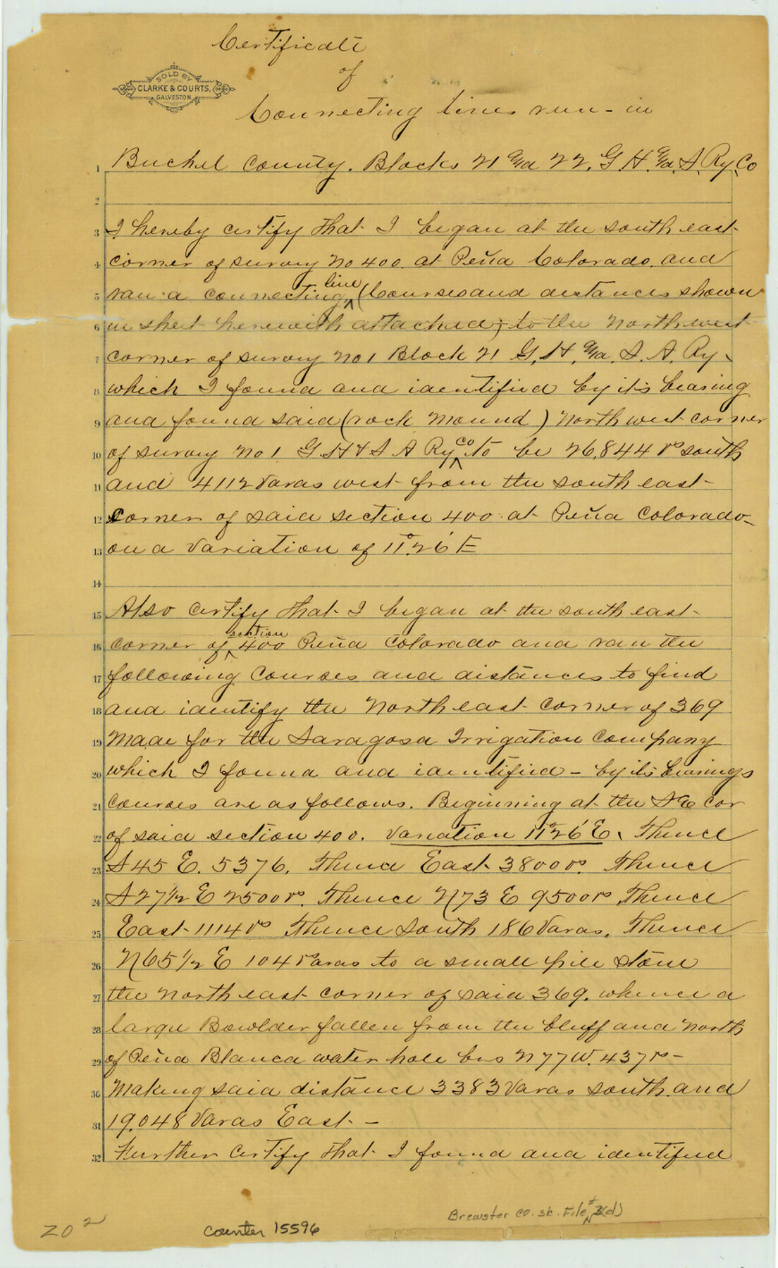
[Connecting line from NE corner of survey 369 Pena Blanca to SW corner of survey 4, Block 5, G. C. & S. F. Ry. and connecting line from SE corner of survey 400, Pena Colorado to NW corner of survey 1, Block 21, G. H. & S. A. Ry.]
-
Map/Doc
15596
-
Collection
General Map Collection
-
Object Dates
1889/7/11 (Creation Date)
-
People and Organizations
W.S. Mabry (Surveyor/Engineer)
-
Counties
Brewster
-
Subjects
Surveying Sketch File
-
Height x Width
14.2 x 8.7 inches
36.1 x 22.1 cm
-
Medium
paper, manuscript
-
Features
Pena Colorado [Mountain]
Part of: General Map Collection
Flight Mission No. BQY-4M, Frame 116, Harris County

Print $20.00
- Digital $50.00
Flight Mission No. BQY-4M, Frame 116, Harris County
1953
Size 18.5 x 22.4 inches
Map/Doc 85283
Zapata County Rolled Sketch 10A

Print $20.00
- Digital $50.00
Zapata County Rolled Sketch 10A
1912
Size 26.3 x 26.5 inches
Map/Doc 8312
Flight Mission No. BQY-4M, Frame 117, Harris County

Print $20.00
- Digital $50.00
Flight Mission No. BQY-4M, Frame 117, Harris County
1953
Size 18.5 x 22.3 inches
Map/Doc 85284
Limestone County Working Sketch 10

Print $20.00
- Digital $50.00
Limestone County Working Sketch 10
1922
Size 21.1 x 10.0 inches
Map/Doc 70560
Crockett County Sketch File 62

Print $6.00
- Digital $50.00
Crockett County Sketch File 62
1927
Size 14.2 x 8.8 inches
Map/Doc 19848
Tyler County Rolled Sketch 2

Print $20.00
- Digital $50.00
Tyler County Rolled Sketch 2
1944
Size 29.6 x 17.4 inches
Map/Doc 8056
San Luis Pass to East Matagorda Bay

Print $20.00
- Digital $50.00
San Luis Pass to East Matagorda Bay
1957
Size 34.9 x 46.9 inches
Map/Doc 69962
Martin County Sketch File 14

Print $46.00
- Digital $50.00
Martin County Sketch File 14
1937
Size 11.2 x 8.8 inches
Map/Doc 30671
Harris County Sketch File 65

Print $20.00
- Digital $50.00
Harris County Sketch File 65
Size 23.5 x 35.1 inches
Map/Doc 11660
Orange County Rolled Sketch 18

Print $20.00
- Digital $50.00
Orange County Rolled Sketch 18
Size 11.6 x 12.6 inches
Map/Doc 7182
Flight Mission No. DCL-6C, Frame 15, Kenedy County

Print $20.00
- Digital $50.00
Flight Mission No. DCL-6C, Frame 15, Kenedy County
1943
Size 18.7 x 22.4 inches
Map/Doc 85872

You may also like
Val Verde County Sketch File 35

Print $23.00
- Digital $50.00
Val Verde County Sketch File 35
1937
Size 15.3 x 9.4 inches
Map/Doc 12574
General Highway Map, Atascosa County, Texas

Print $20.00
General Highway Map, Atascosa County, Texas
1961
Size 18.3 x 25.0 inches
Map/Doc 79355
Coke County Sketch File 33

Print $20.00
- Digital $50.00
Coke County Sketch File 33
Size 22.0 x 26.6 inches
Map/Doc 11115
Denison, Texas, Grayson County 1886

Print $20.00
Denison, Texas, Grayson County 1886
1886
Size 21.1 x 30.5 inches
Map/Doc 93466
Brewster County Rolled Sketch 145

Print $20.00
- Digital $50.00
Brewster County Rolled Sketch 145
1944
Size 24.1 x 18.5 inches
Map/Doc 5312
Castro County Boundary File 1 and 1a

Print $44.00
- Digital $50.00
Castro County Boundary File 1 and 1a
Size 8.9 x 9.9 inches
Map/Doc 51186
[Surveys along Big Blue Creek]
![91510, [Surveys along Big Blue Creek], Twichell Survey Records](https://historictexasmaps.com/wmedia_w700/maps/91510-1.tif.jpg)
Print $3.00
- Digital $50.00
[Surveys along Big Blue Creek]
Size 9.5 x 14.8 inches
Map/Doc 91510
Flight Mission No. CLL-1N, Frame 112, Willacy County

Print $20.00
- Digital $50.00
Flight Mission No. CLL-1N, Frame 112, Willacy County
1954
Size 18.4 x 20.1 inches
Map/Doc 87046
Fisher County Sketch File 6

Print $6.00
- Digital $50.00
Fisher County Sketch File 6
Size 9.7 x 15.9 inches
Map/Doc 22563
Wilson County Working Sketch 12

Print $20.00
- Digital $50.00
Wilson County Working Sketch 12
1981
Size 19.5 x 12.9 inches
Map/Doc 72592
Frio County Rolled Sketch 11

Print $20.00
- Digital $50.00
Frio County Rolled Sketch 11
1948
Size 44.4 x 43.8 inches
Map/Doc 8903
Comal County Rolled Sketch 2

Print $20.00
- Digital $50.00
Comal County Rolled Sketch 2
1974
Size 21.8 x 13.3 inches
Map/Doc 5537