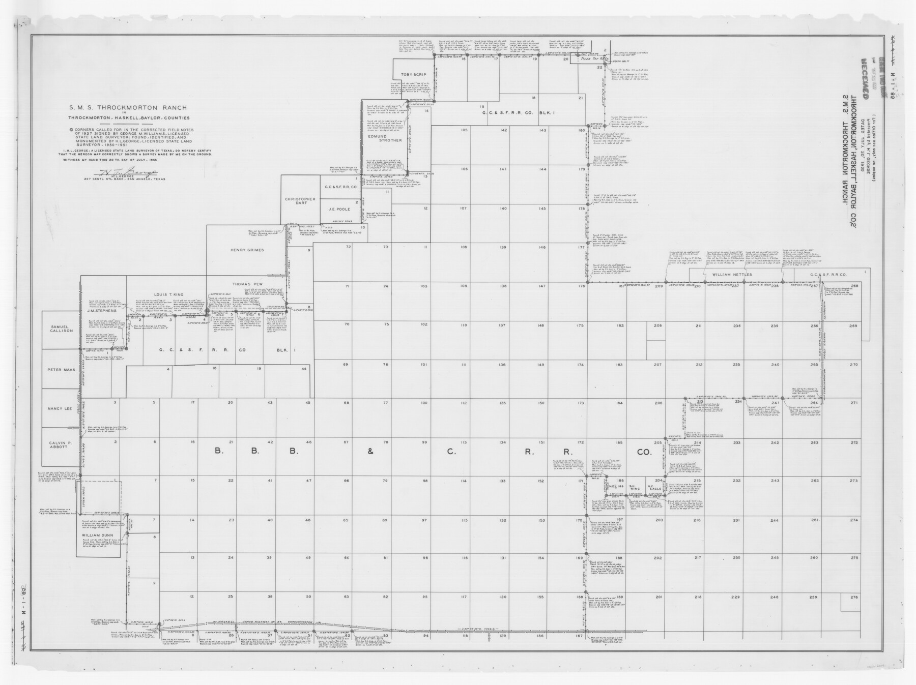
S. M. S. Throckmorton Ranch, Throckmorton, Haskell, Baylor Cos.
RG-4-18a; N-1-85
-
Map/Doc
2104
-
Collection
General Map Collection
-
Object Dates
1955 (Creation Date)
-
People and Organizations
H.L. George (Surveyor/Engineer)
-
Counties
Baylor
-
Height x Width
33.8 x 45.1 inches
85.9 x 114.6 cm
-
Comments
Filed for information only.
Part of: General Map Collection
Titus County Sketch File 11

Print $4.00
- Digital $50.00
Titus County Sketch File 11
1872
Size 8.2 x 10.1 inches
Map/Doc 38150
Erath County Working Sketch 26

Print $20.00
- Digital $50.00
Erath County Working Sketch 26
1969
Size 20.8 x 15.0 inches
Map/Doc 69107
Rusk County Working Sketch 24

Print $20.00
- Digital $50.00
Rusk County Working Sketch 24
1949
Size 20.2 x 24.7 inches
Map/Doc 63660
Panola County

Print $20.00
- Digital $50.00
Panola County
1947
Size 38.6 x 38.2 inches
Map/Doc 77390
Gray County Sketch File 5

Print $16.00
- Digital $50.00
Gray County Sketch File 5
1882
Size 12.8 x 8.3 inches
Map/Doc 24418
Uvalde County Rolled Sketch 9

Print $20.00
- Digital $50.00
Uvalde County Rolled Sketch 9
1924
Size 16.6 x 24.6 inches
Map/Doc 8094
Mason County Rolled Sketch 2

Print $20.00
- Digital $50.00
Mason County Rolled Sketch 2
1952
Size 32.9 x 26.7 inches
Map/Doc 6675
Flight Mission No. DAG-24K, Frame 132, Matagorda County

Print $20.00
- Digital $50.00
Flight Mission No. DAG-24K, Frame 132, Matagorda County
1953
Size 15.8 x 15.8 inches
Map/Doc 86550
Hockley County Sketch File 9

Print $40.00
- Digital $50.00
Hockley County Sketch File 9
1912
Size 48.2 x 12.8 inches
Map/Doc 10491
Flight Mission No. DAG-21K, Frame 39, Matagorda County

Print $20.00
- Digital $50.00
Flight Mission No. DAG-21K, Frame 39, Matagorda County
1952
Size 18.6 x 22.3 inches
Map/Doc 86406
Webb County Rolled Sketch 74

Print $20.00
- Digital $50.00
Webb County Rolled Sketch 74
1982
Size 40.7 x 31.9 inches
Map/Doc 10131
Webb County Sketch File 11a-1

Print $27.00
- Digital $50.00
Webb County Sketch File 11a-1
1884
Size 22.2 x 9.3 inches
Map/Doc 12626
You may also like
General Highway Map, Howard County, Texas

Print $20.00
General Highway Map, Howard County, Texas
1940
Size 18.5 x 24.7 inches
Map/Doc 79134
Loving County Sketch File 3

Print $6.00
- Digital $50.00
Loving County Sketch File 3
1952
Size 11.2 x 8.7 inches
Map/Doc 30409
Flight Mission No. DCL-5C, Frame 72, Kenedy County

Print $20.00
- Digital $50.00
Flight Mission No. DCL-5C, Frame 72, Kenedy County
1943
Size 18.7 x 22.5 inches
Map/Doc 85855
[Surveys along the Leon River]
![82093, [Surveys along the Leon River], General Map Collection](https://historictexasmaps.com/wmedia_w700/maps/82093.tif.jpg)
Print $20.00
- Digital $50.00
[Surveys along the Leon River]
1840
Size 20.5 x 6.7 inches
Map/Doc 82093
Webb County Sketch File 46

Print $20.00
- Digital $50.00
Webb County Sketch File 46
1879
Size 19.6 x 14.9 inches
Map/Doc 12644
Bexar County Working Sketch 21

Print $20.00
- Digital $50.00
Bexar County Working Sketch 21
1984
Size 21.3 x 28.8 inches
Map/Doc 67337

Stephens County Texas

Print $20.00
- Digital $50.00
Stephens County Texas
Size 20.8 x 18.6 inches
Map/Doc 4627
[Sketch for Mineral Application 36425 - Jefferson County, Ley C. Moore]
![65616, [Sketch for Mineral Application 36425 - Jefferson County, Ley C. Moore], General Map Collection](https://historictexasmaps.com/wmedia_w700/maps/65616.tif.jpg)
Print $40.00
- Digital $50.00
[Sketch for Mineral Application 36425 - Jefferson County, Ley C. Moore]
1942
Size 49.2 x 35.0 inches
Map/Doc 65616
General Highway Map, Hemphill County, Texas

Print $20.00
General Highway Map, Hemphill County, Texas
1961
Size 18.3 x 24.6 inches
Map/Doc 79515
Motley County Sketch File 38 (N)

Print $106.00
- Digital $50.00
Motley County Sketch File 38 (N)
1910
Size 14.4 x 8.8 inches
Map/Doc 32086
Flight Mission No. CRE-2R, Frame 88, Jackson County

Print $20.00
- Digital $50.00
Flight Mission No. CRE-2R, Frame 88, Jackson County
1956
Size 15.9 x 15.9 inches
Map/Doc 85360