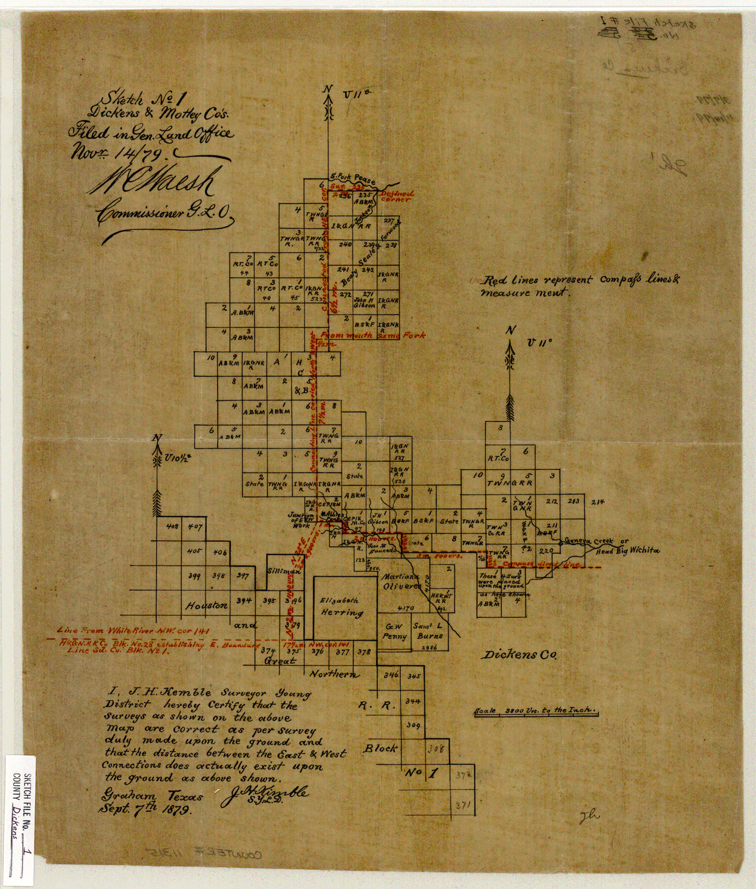
Dickens County Sketch File 1
Dickens & Motley Co's.
-
Map/Doc
11315
-
Collection
General Map Collection
-
Object Dates
1879/9/7 (Creation Date)
1879/11/14 (File Date)
-
People and Organizations
J.H. Kimble (Surveyor/Engineer)
-
Counties
Dickens Motley
-
Subjects
Surveying Sketch File
-
Height x Width
18.2 x 15.5 inches
46.2 x 39.4 cm
-
Medium
paper, manuscript
-
Scale
1:3800
-
Features
South Fork of Pease River
Jackson Creek
Geneva Creek
Head of Big Wichita River
Part of: General Map Collection
Right of Way & Track Map Houston & Brazos Valley Ry. operated by Houston & Brazos Valley Ry. Co., Hoskins Mound Branch

Print $40.00
- Digital $50.00
Right of Way & Track Map Houston & Brazos Valley Ry. operated by Houston & Brazos Valley Ry. Co., Hoskins Mound Branch
1924
Size 25.0 x 56.6 inches
Map/Doc 64610
Flight Mission No. DQO-14T, Frame 65, Galveston County

Print $20.00
- Digital $50.00
Flight Mission No. DQO-14T, Frame 65, Galveston County
1958
Size 17.6 x 17.4 inches
Map/Doc 85216
La Salle County Sketch File 21

Print $6.00
- Digital $50.00
La Salle County Sketch File 21
1883
Size 11.0 x 10.5 inches
Map/Doc 29526
Brazoria County Rolled Sketch 46

Print $40.00
- Digital $50.00
Brazoria County Rolled Sketch 46
1950
Size 30.7 x 57.3 inches
Map/Doc 8462
Crockett County Working Sketch 46

Print $20.00
- Digital $50.00
Crockett County Working Sketch 46
1935
Size 32.9 x 27.4 inches
Map/Doc 68379
Flight Mission No. BQR-9K, Frame 43, Brazoria County

Print $20.00
- Digital $50.00
Flight Mission No. BQR-9K, Frame 43, Brazoria County
1952
Size 18.6 x 22.3 inches
Map/Doc 84047
Jim Hogg County Boundary File 1

Print $16.00
- Digital $50.00
Jim Hogg County Boundary File 1
Size 11.4 x 8.8 inches
Map/Doc 55519
Travis County Rolled Sketch 31

Print $20.00
- Digital $50.00
Travis County Rolled Sketch 31
1943
Size 43.4 x 27.3 inches
Map/Doc 8033
Randall County Sketch File 2

Print $4.00
- Digital $50.00
Randall County Sketch File 2
1913
Size 7.3 x 8.8 inches
Map/Doc 34961
McMullen County Working Sketch 7

Print $20.00
- Digital $50.00
McMullen County Working Sketch 7
1926
Size 20.7 x 17.5 inches
Map/Doc 70708
Rucker's Work on Upper Red River

Print $20.00
- Digital $50.00
Rucker's Work on Upper Red River
1857
Size 39.3 x 26.2 inches
Map/Doc 3220
Flight Mission No. BRA-17M, Frame 12, Jefferson County

Print $20.00
- Digital $50.00
Flight Mission No. BRA-17M, Frame 12, Jefferson County
1953
Size 18.5 x 22.3 inches
Map/Doc 85793
You may also like
[G. & M. Block O, M. B. & A. Block N, PSL Blocks B-19 and B-29 showing alleged vacancy]
![89812, [G. & M. Block O, M. B. & A. Block N, PSL Blocks B-19 and B-29 showing alleged vacancy], Twichell Survey Records](https://historictexasmaps.com/wmedia_w700/maps/89812-1.tif.jpg)
Print $40.00
- Digital $50.00
[G. & M. Block O, M. B. & A. Block N, PSL Blocks B-19 and B-29 showing alleged vacancy]
Size 72.2 x 36.9 inches
Map/Doc 89812
Flight Mission No. DQN-2K, Frame 30, Calhoun County

Print $20.00
- Digital $50.00
Flight Mission No. DQN-2K, Frame 30, Calhoun County
1953
Size 18.5 x 22.2 inches
Map/Doc 84237
Map of Cherokee County, Texas

Print $20.00
- Digital $50.00
Map of Cherokee County, Texas
1879
Size 30.8 x 24.0 inches
Map/Doc 696
Sketch of Surveys on Caranchua and Tres Palacious Bayous, Jackson Co.

Print $2.00
- Digital $50.00
Sketch of Surveys on Caranchua and Tres Palacious Bayous, Jackson Co.
Size 7.9 x 7.8 inches
Map/Doc 69743
Flight Mission No. CRC-2R, Frame 136, Chambers County

Print $20.00
- Digital $50.00
Flight Mission No. CRC-2R, Frame 136, Chambers County
1956
Size 18.7 x 22.4 inches
Map/Doc 84752
[Topographical Map]
![92543, [Topographical Map], Twichell Survey Records](https://historictexasmaps.com/wmedia_w700/maps/92543-1.tif.jpg)
Print $20.00
- Digital $50.00
[Topographical Map]
Size 31.2 x 37.5 inches
Map/Doc 92543
Donley County Rolled Sketch 1

Print $20.00
- Digital $50.00
Donley County Rolled Sketch 1
1939
Size 19.6 x 15.1 inches
Map/Doc 5728
San Jacinto County

Print $40.00
- Digital $50.00
San Jacinto County
1942
Size 48.7 x 43.1 inches
Map/Doc 73282
Bandera County Working Sketch 16a

Print $20.00
- Digital $50.00
Bandera County Working Sketch 16a
1941
Size 12.8 x 22.1 inches
Map/Doc 67609
Topographic Map of Texas and Oklahoma Boundary, Fort Augur Area

Print $20.00
Topographic Map of Texas and Oklahoma Boundary, Fort Augur Area
1924
Size 17.2 x 33.7 inches
Map/Doc 79754
Blanco County Working Sketch 45

Print $20.00
- Digital $50.00
Blanco County Working Sketch 45
2007
Size 23.9 x 34.0 inches
Map/Doc 88609
[Blocks M-23, M-17, M-18, H, G, and vicinity]
![91141, [Blocks M-23, M-17, M-18, H, G, and vicinity], Twichell Survey Records](https://historictexasmaps.com/wmedia_w700/maps/91141-1.tif.jpg)
Print $20.00
- Digital $50.00
[Blocks M-23, M-17, M-18, H, G, and vicinity]
1882
Size 12.9 x 12.4 inches
Map/Doc 91141