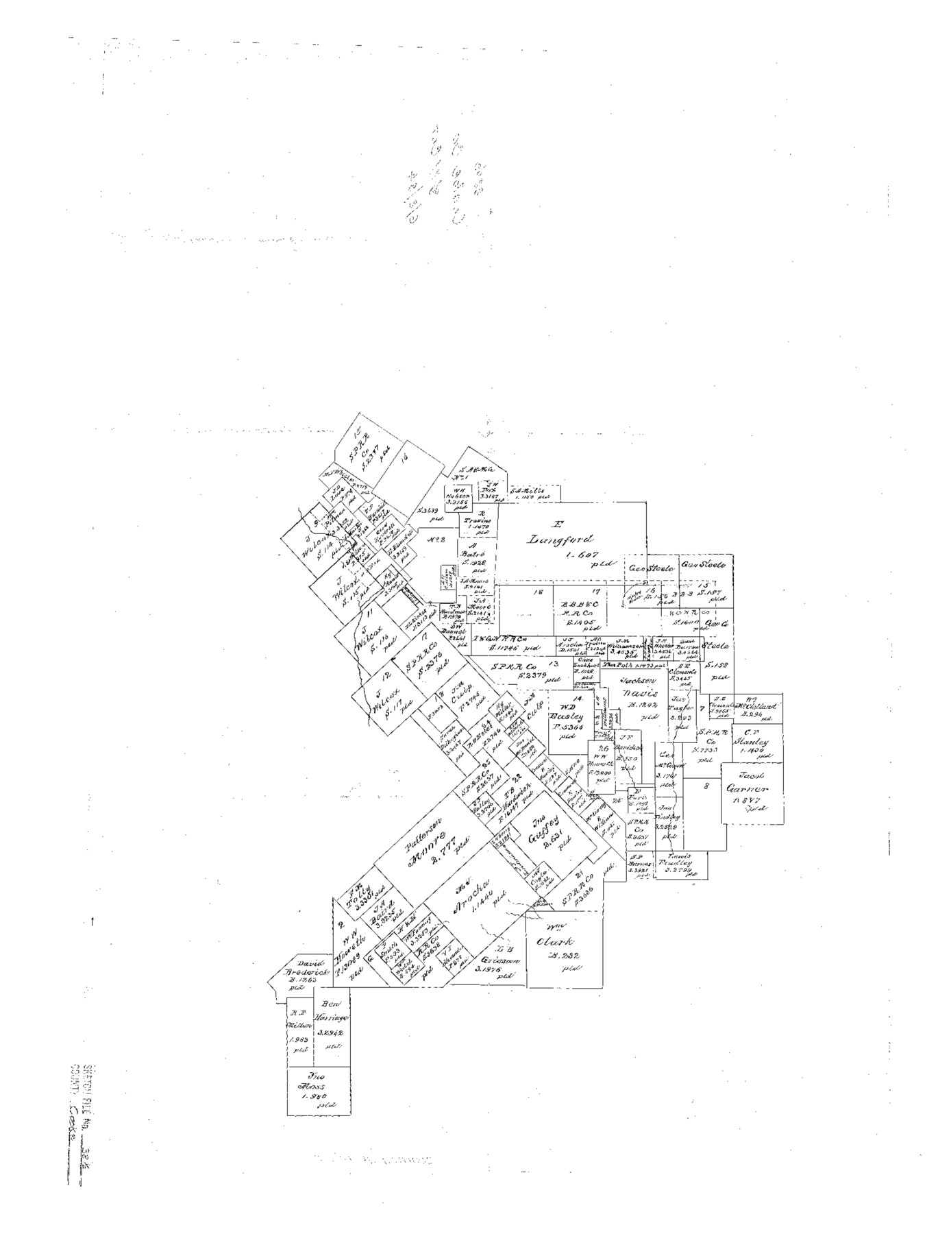
Cooke County Sketch File 38 1/2
S W Cor.
-
Map/Doc
11175
-
Collection
General Map Collection
-
Object Dates
1894/6/8 (File Date)
-
People and Organizations
Hill (Surveyor/Engineer)
-
Counties
Cooke
-
Subjects
Surveying Sketch File
-
Height x Width
21.5 x 16.6 inches
54.6 x 42.2 cm
-
Medium
paper, photocopy
Part of: General Map Collection
Young County Working Sketch 20

Print $20.00
- Digital $50.00
Young County Working Sketch 20
1961
Size 25.5 x 23.2 inches
Map/Doc 62043
Throckmorton County Boundary File 4

Print $6.00
- Digital $50.00
Throckmorton County Boundary File 4
Size 14.3 x 8.8 inches
Map/Doc 59283
Right of Way and Track Map International & Gt. Northern Ry. operated by the International & Gt. Northern Ry. Co., Columbia Branch Gulf Division

Print $40.00
- Digital $50.00
Right of Way and Track Map International & Gt. Northern Ry. operated by the International & Gt. Northern Ry. Co., Columbia Branch Gulf Division
1917
Size 24.8 x 56.3 inches
Map/Doc 64593
Bowie County Sketch File 7c

Print $7.00
- Digital $50.00
Bowie County Sketch File 7c
Size 11.9 x 7.4 inches
Map/Doc 14864
Flight Mission No. DAG-21K, Frame 101, Matagorda County

Print $20.00
- Digital $50.00
Flight Mission No. DAG-21K, Frame 101, Matagorda County
1952
Size 18.6 x 22.4 inches
Map/Doc 86430
Central Part of Jeff Davis Co.

Print $40.00
- Digital $50.00
Central Part of Jeff Davis Co.
1982
Size 56.3 x 43.9 inches
Map/Doc 95543
Flight Mission No. CRK-3P, Frame 174, Refugio County

Print $20.00
- Digital $50.00
Flight Mission No. CRK-3P, Frame 174, Refugio County
1956
Size 18.6 x 22.3 inches
Map/Doc 86921
Intracoastal Waterway - Galveston Bay to West Bay including Galveston Bay Entrance

Print $20.00
- Digital $50.00
Intracoastal Waterway - Galveston Bay to West Bay including Galveston Bay Entrance
1962
Size 26.8 x 38.4 inches
Map/Doc 69937
Aransas Pass to Baffin Bay

Print $20.00
- Digital $50.00
Aransas Pass to Baffin Bay
1938
Size 41.6 x 34.5 inches
Map/Doc 73411
Runnels County Working Sketch 13

Print $20.00
- Digital $50.00
Runnels County Working Sketch 13
1950
Size 19.4 x 17.8 inches
Map/Doc 63609
Jefferson County Sketch File 4

Print $4.00
- Digital $50.00
Jefferson County Sketch File 4
Size 13.0 x 8.3 inches
Map/Doc 28101
Flight Mission No. DAG-23K, Frame 13, Matagorda County

Print $20.00
- Digital $50.00
Flight Mission No. DAG-23K, Frame 13, Matagorda County
1953
Size 18.5 x 22.2 inches
Map/Doc 86475
You may also like
Loving County Rolled Sketch 2

Print $40.00
- Digital $50.00
Loving County Rolled Sketch 2
1952
Size 42.4 x 70.4 inches
Map/Doc 9462
Map Showing Survey and Subdivision of the Wendlandt Property in Outlot 4, Division "Z"

Print $3.00
- Digital $50.00
Map Showing Survey and Subdivision of the Wendlandt Property in Outlot 4, Division "Z"
1910
Size 10.8 x 17.7 inches
Map/Doc 508
Flight Mission No. DQO-1K, Frame 119, Galveston County

Print $20.00
- Digital $50.00
Flight Mission No. DQO-1K, Frame 119, Galveston County
1952
Size 19.0 x 22.6 inches
Map/Doc 84997
Childress Co.

Print $20.00
- Digital $50.00
Childress Co.
1978
Size 46.2 x 35.0 inches
Map/Doc 73105
Angelina County Sketch File 5a

Print $4.00
- Digital $50.00
Angelina County Sketch File 5a
1857
Size 8.6 x 7.7 inches
Map/Doc 12931
Schleicher County Sketch File 31

Print $4.00
- Digital $50.00
Schleicher County Sketch File 31
1940
Size 11.3 x 8.7 inches
Map/Doc 36530
Map of Alabama and Texas Cattle Co's Pasture

Print $20.00
- Digital $50.00
Map of Alabama and Texas Cattle Co's Pasture
Size 17.6 x 18.1 inches
Map/Doc 5064
Harris County Sketch File 5

Print $20.00
- Digital $50.00
Harris County Sketch File 5
1858
Size 22.0 x 15.0 inches
Map/Doc 11648
Val Verde County Rolled Sketch 55

Print $20.00
- Digital $50.00
Val Verde County Rolled Sketch 55
1940
Size 32.0 x 23.3 inches
Map/Doc 8124
[Capitol League Surveys in Hartley County, Texas]
![1766, [Capitol League Surveys in Hartley County, Texas], General Map Collection](https://historictexasmaps.com/wmedia_w700/maps/1766.tif.jpg)
Print $20.00
- Digital $50.00
[Capitol League Surveys in Hartley County, Texas]
1910
Size 19.6 x 27.9 inches
Map/Doc 1766
[San Antonio & Aransas Pass Railway Co.]
![64262, [San Antonio & Aransas Pass Railway Co.], General Map Collection](https://historictexasmaps.com/wmedia_w700/maps/64262-1.tif.jpg)
Print $40.00
- Digital $50.00
[San Antonio & Aransas Pass Railway Co.]
Size 15.7 x 86.4 inches
Map/Doc 64262
![91538, [Block 3T], Twichell Survey Records](https://historictexasmaps.com/wmedia_w700/maps/91538-1.tif.jpg)