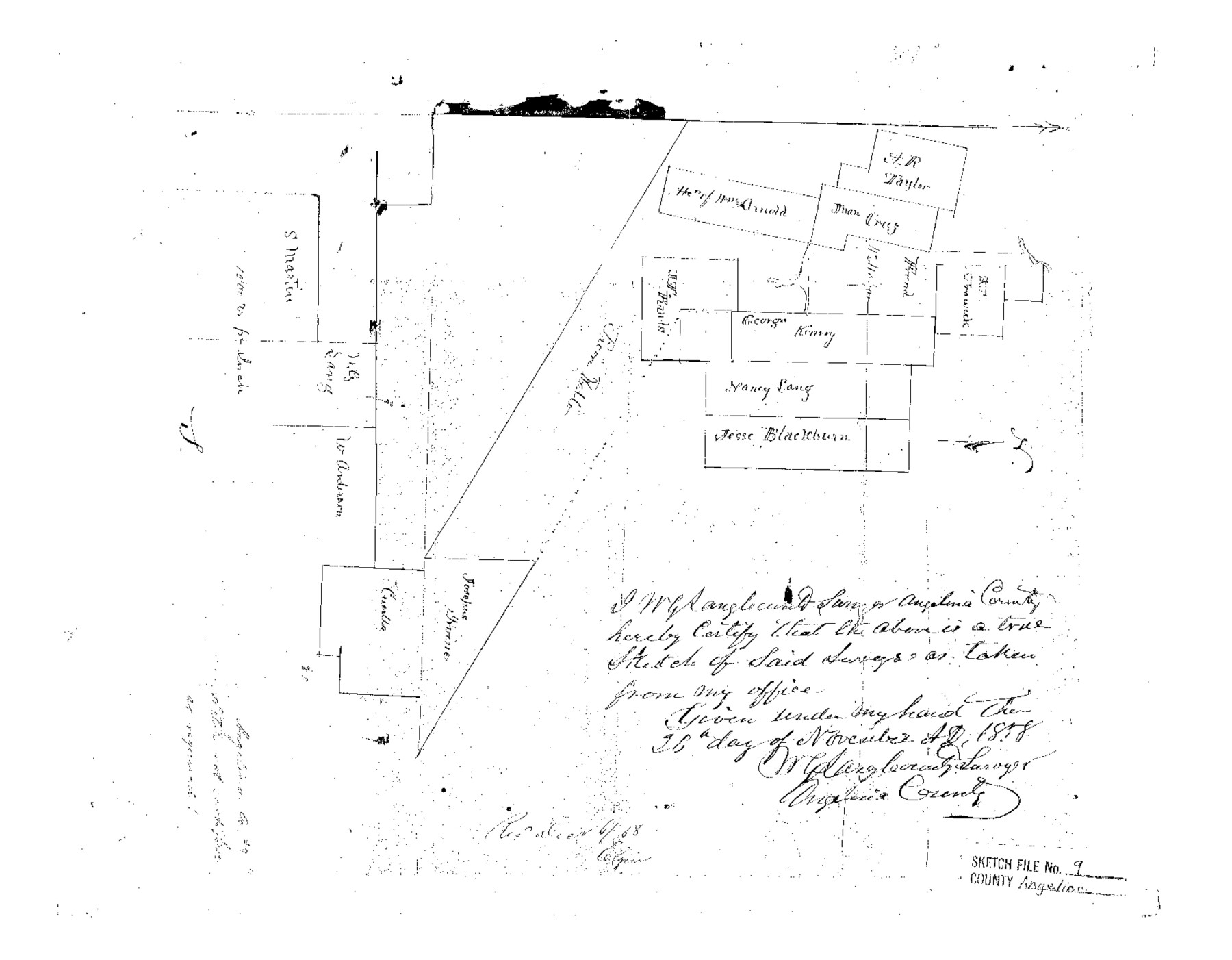
Angelina County Sketch File 9
[Sketch of surveys in northeast part of county south of Angelina River]
-
Map/Doc
10813
-
Collection
General Map Collection
-
Object Dates
1858/11/26 (Creation Date)
1858/12/6 (File Date)
-
People and Organizations
W.G. Lang (Surveyor/Engineer)
-
Counties
Angelina
-
Subjects
Surveying Sketch File
-
Height x Width
12.3 x 15.8 inches
31.2 x 40.1 cm
-
Medium
paper, manuscript
-
Features
[Angelina River]
Part of: General Map Collection
Hidalgo County Rolled Sketch 14

Print $40.00
- Digital $50.00
Hidalgo County Rolled Sketch 14
1963
Size 68.5 x 40.7 inches
Map/Doc 9169
Nueces River, Bluntzer Sheet

Print $20.00
- Digital $50.00
Nueces River, Bluntzer Sheet
1927
Size 35.3 x 42.9 inches
Map/Doc 65088
Flight Mission No. BRE-2P, Frame 96, Nueces County

Print $20.00
- Digital $50.00
Flight Mission No. BRE-2P, Frame 96, Nueces County
1956
Size 18.4 x 22.3 inches
Map/Doc 86781
Chambers County Sketch File 46

Print $356.00
- Digital $50.00
Chambers County Sketch File 46
1927
Size 20.7 x 7.3 inches
Map/Doc 17751
Armstrong County

Print $20.00
- Digital $50.00
Armstrong County
1904
Size 40.4 x 33.8 inches
Map/Doc 3247
Presidio County Rolled Sketch 144

Print $20.00
- Digital $50.00
Presidio County Rolled Sketch 144
2010
Size 36.0 x 24.0 inches
Map/Doc 89602
Texas Panhandle East Boundary Line

Print $20.00
- Digital $50.00
Texas Panhandle East Boundary Line
1898
Size 32.1 x 8.8 inches
Map/Doc 1700
Collin County Sketch File 15

Print $4.00
- Digital $50.00
Collin County Sketch File 15
1873
Size 10.0 x 8.0 inches
Map/Doc 18880
Anderson County Sketch File 27

Print $40.00
- Digital $50.00
Anderson County Sketch File 27
1970
Size 19.5 x 23.7 inches
Map/Doc 10806
Blanco County Sketch File 33

Print $4.00
- Digital $50.00
Blanco County Sketch File 33
Size 7.9 x 7.0 inches
Map/Doc 14635

Houston County Sketch File 24a

Print $20.00
- Digital $50.00
Houston County Sketch File 24a
1873
Size 26.3 x 21.0 inches
Map/Doc 11787
You may also like
Chambers County Sketch File 6

Print $4.00
- Digital $50.00
Chambers County Sketch File 6
1863
Size 9.1 x 8.5 inches
Map/Doc 17540
Lubbock County Rolled Sketch 4

Print $20.00
- Digital $50.00
Lubbock County Rolled Sketch 4
Size 34.1 x 45.5 inches
Map/Doc 76179

[H. & T. C. Block 47, H. & G. N. Block E]
![91259, [H. & T. C. Block 47, H. & G. N. Block E], Twichell Survey Records](https://historictexasmaps.com/wmedia_w700/maps/91259-1.tif.jpg)
Print $20.00
- Digital $50.00
[H. & T. C. Block 47, H. & G. N. Block E]
1874
Size 22.1 x 12.9 inches
Map/Doc 91259
Supplemental Plat, T. 4S., R. 14W., Indian Meridian, Oklahoma

Print $4.00
- Digital $50.00
Supplemental Plat, T. 4S., R. 14W., Indian Meridian, Oklahoma
1924
Size 17.4 x 23.1 inches
Map/Doc 75148
University Land Field Notes for Blocks 39, 41, 42, 44, 45, 46, 47, 50, and 51 in Crockett County, Blocks 38 and 40 in Crockett and Irion Counties, and Blocks 48 and 49 in Crockett and Reagan Counties, and Block 43 in Crockett, Irion, and Reagan Counties

University Land Field Notes for Blocks 39, 41, 42, 44, 45, 46, 47, 50, and 51 in Crockett County, Blocks 38 and 40 in Crockett and Irion Counties, and Blocks 48 and 49 in Crockett and Reagan Counties, and Block 43 in Crockett, Irion, and Reagan Counties
Map/Doc 81718
Bowie County Rolled Sketch 3

Print $57.00
- Digital $50.00
Bowie County Rolled Sketch 3
1970
Size 10.0 x 15.3 inches
Map/Doc 42739
Flight Mission No. BRE-2P, Frame 82, Nueces County

Print $20.00
- Digital $50.00
Flight Mission No. BRE-2P, Frame 82, Nueces County
1956
Size 18.5 x 22.6 inches
Map/Doc 86777
Travis County Rolled Sketch 47

Print $40.00
- Digital $50.00
Travis County Rolled Sketch 47
1925
Size 24.9 x 56.8 inches
Map/Doc 10016
Duval County Rolled Sketch Pressly No. 1A

Print $20.00
- Digital $50.00
Duval County Rolled Sketch Pressly No. 1A
1935
Size 25.4 x 37.6 inches
Map/Doc 5769
[Block B9 in Southwest Corner of Crosby County]
![90497, [Block B9 in Southwest Corner of Crosby County], Twichell Survey Records](https://historictexasmaps.com/wmedia_w700/maps/90497-1.tif.jpg)
Print $20.00
- Digital $50.00
[Block B9 in Southwest Corner of Crosby County]
Size 12.3 x 16.0 inches
Map/Doc 90497
Zavalla County

Print $20.00
- Digital $50.00
Zavalla County
1879
Size 22.8 x 27.2 inches
Map/Doc 4182