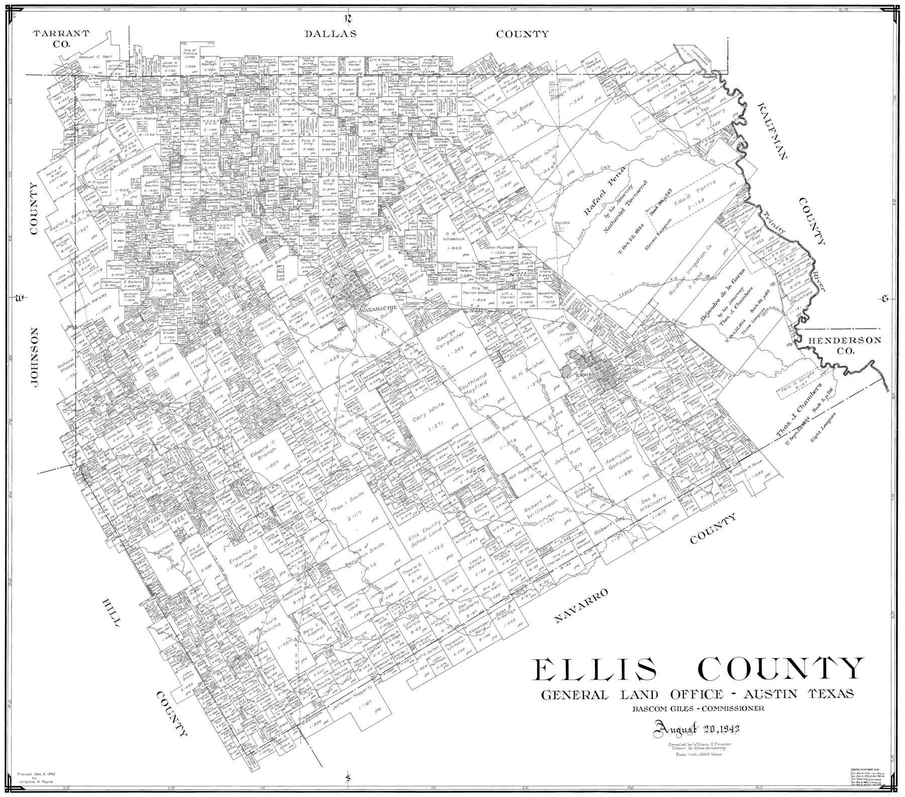
Ellis County
-
Map/Doc
77272
-
Collection
General Map Collection
-
Object Dates
1943/8/20 (Creation Date)
-
People and Organizations
Eltea Armstrong (Draftsman)
William O. Proctor (Compiler)
-
Counties
Ellis
-
Subjects
County
-
Height x Width
38.3 x 43.4 inches
97.3 x 110.2 cm
Part of: General Map Collection
Childress County Rolled Sketch 9A

Print $20.00
- Digital $50.00
Childress County Rolled Sketch 9A
Size 17.0 x 17.1 inches
Map/Doc 5447
Stephens County Sketch File 10b

Print $8.00
- Digital $50.00
Stephens County Sketch File 10b
1890
Size 8.5 x 7.8 inches
Map/Doc 37048
Chambers County Rolled Sketch 20

Print $1171.00
- Digital $50.00
Chambers County Rolled Sketch 20
Size 10.7 x 16.2 inches
Map/Doc 43987
Pecos County Rolled Sketch 95

Print $20.00
- Digital $50.00
Pecos County Rolled Sketch 95
Size 18.6 x 25.9 inches
Map/Doc 7247
Duval County Sketch File 19a

Print $40.00
- Digital $50.00
Duval County Sketch File 19a
1880
Size 12.7 x 14.2 inches
Map/Doc 21318
[Surveys in Polk and Tyler Counties, Liberty District]
![354, [Surveys in Polk and Tyler Counties, Liberty District], General Map Collection](https://historictexasmaps.com/wmedia_w700/maps/354.tif.jpg)
Print $2.00
- Digital $50.00
[Surveys in Polk and Tyler Counties, Liberty District]
1847
Size 10.8 x 8.1 inches
Map/Doc 354
Coke County Working Sketch Graphic Index

Print $20.00
- Digital $50.00
Coke County Working Sketch Graphic Index
1945
Size 38.9 x 41.5 inches
Map/Doc 76496
Louisiana and Texas Intracoastal Waterway - Matagorda-Espiritu Santo and San Antonio Bays, Section 8-9, Survey of 1927-8 - Index Sheet 3

Print $20.00
- Digital $50.00
Louisiana and Texas Intracoastal Waterway - Matagorda-Espiritu Santo and San Antonio Bays, Section 8-9, Survey of 1927-8 - Index Sheet 3
1929
Size 31.0 x 42.8 inches
Map/Doc 61837
Flight Mission No. DQN-1K, Frame 157, Calhoun County

Print $20.00
- Digital $50.00
Flight Mission No. DQN-1K, Frame 157, Calhoun County
1953
Size 18.4 x 22.2 inches
Map/Doc 84216
Bowie County Working Sketch 12

Print $20.00
- Digital $50.00
Bowie County Working Sketch 12
1959
Size 31.3 x 23.3 inches
Map/Doc 67416
Hudspeth County Sketch File 45

Print $38.00
- Digital $50.00
Hudspeth County Sketch File 45
1982
Size 11.2 x 8.8 inches
Map/Doc 27030
Titus County Boundary File 29

Print $72.00
- Digital $50.00
Titus County Boundary File 29
Size 9.0 x 4.1 inches
Map/Doc 59311
You may also like
Henderson County Working Sketch 26

Print $20.00
- Digital $50.00
Henderson County Working Sketch 26
1954
Size 23.8 x 23.5 inches
Map/Doc 66159
Jeff Davis County Sketch File 30

Print $26.00
- Digital $50.00
Jeff Davis County Sketch File 30
1922
Size 14.1 x 8.5 inches
Map/Doc 28014
Goliad County Sketch File 5

Print $6.00
- Digital $50.00
Goliad County Sketch File 5
Size 15.9 x 10.2 inches
Map/Doc 24218
Flight Mission No. DQN-7K, Frame 33, Calhoun County

Print $20.00
- Digital $50.00
Flight Mission No. DQN-7K, Frame 33, Calhoun County
1953
Size 18.5 x 22.1 inches
Map/Doc 84471
Map of Runnels County, Texas

Print $20.00
- Digital $50.00
Map of Runnels County, Texas
1879
Size 28.8 x 22.0 inches
Map/Doc 5035
La Salle County Rolled Sketch 29

Print $20.00
- Digital $50.00
La Salle County Rolled Sketch 29
1984
Size 17.9 x 17.3 inches
Map/Doc 6589
Map of Parker County

Print $20.00
- Digital $50.00
Map of Parker County
1871
Size 20.9 x 18.4 inches
Map/Doc 3942
Menard County Working Sketch 16

Print $40.00
- Digital $50.00
Menard County Working Sketch 16
1946
Size 49.1 x 39.1 inches
Map/Doc 70963
Montague County Working Sketch 38

Print $20.00
- Digital $50.00
Montague County Working Sketch 38
1990
Size 14.9 x 15.6 inches
Map/Doc 71104
Copy of Surveyor's Field Book, Morris Browning - In Blocks 7, 5 & 4, I&GNRRCo., Hutchinson and Carson Counties, Texas

Print $2.00
- Digital $50.00
Copy of Surveyor's Field Book, Morris Browning - In Blocks 7, 5 & 4, I&GNRRCo., Hutchinson and Carson Counties, Texas
1888
Size 7.0 x 8.8 inches
Map/Doc 62265
Flight Mission No. CRC-3R, Frame 16, Chambers County

Print $20.00
- Digital $50.00
Flight Mission No. CRC-3R, Frame 16, Chambers County
1956
Size 18.6 x 22.2 inches
Map/Doc 84790
Freestone County Boundary File 30d

Print $20.00
- Digital $50.00
Freestone County Boundary File 30d
Size 8.0 x 29.6 inches
Map/Doc 53608