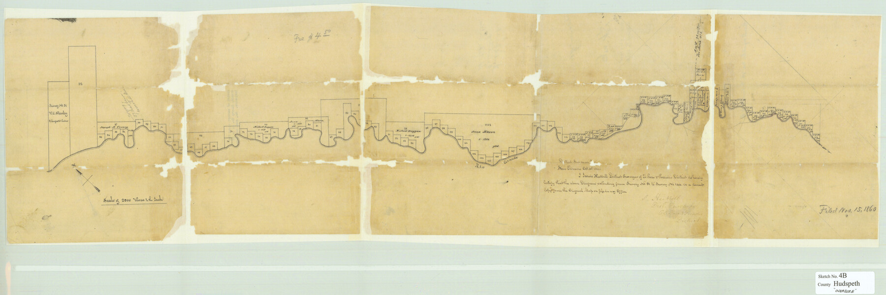
Hudspeth County Sketch File 4b
Sketch of surveys along Rio Grande. Survey No. 51 to 87 inclusive.
-
Map/Doc
10492
-
Collection
General Map Collection
-
Object Dates
10/20/1860 (Creation Date)
-
People and Organizations
Jarvis Hubbell (Surveyor/Engineer)
-
Counties
Hudspeth
-
Subjects
Surveying Sketch File
-
Height x Width
13.0 x 39.2 inches
33.0 x 99.6 cm
-
Medium
paper, manuscript
-
Scale
1:2000
-
Features
Rio Grande
Part of: General Map Collection
Reagan County Working Sketch 31

Print $20.00
- Digital $50.00
Reagan County Working Sketch 31
1964
Size 38.7 x 36.6 inches
Map/Doc 71873
Dickens County Working Sketch 13

Print $20.00
- Digital $50.00
Dickens County Working Sketch 13
1981
Size 26.8 x 21.4 inches
Map/Doc 68661
Houston County Working Sketch 11

Print $20.00
- Digital $50.00
Houston County Working Sketch 11
1953
Size 28.5 x 24.5 inches
Map/Doc 66241
Floyd County Boundary File 2a

Print $40.00
- Digital $50.00
Floyd County Boundary File 2a
Size 19.8 x 39.2 inches
Map/Doc 53488
Brazoria County Working Sketch 47

Print $40.00
- Digital $50.00
Brazoria County Working Sketch 47
1988
Size 35.3 x 59.9 inches
Map/Doc 67532
Gillespie County Sketch File 15

Print $20.00
- Digital $50.00
Gillespie County Sketch File 15
1847
Size 17.7 x 19.3 inches
Map/Doc 11556
Fannin County Sketch File 26

Print $4.00
- Digital $50.00
Fannin County Sketch File 26
1873
Size 8.5 x 10.3 inches
Map/Doc 22495
Chambers County Rolled Sketch 12

Print $20.00
- Digital $50.00
Chambers County Rolled Sketch 12
1935
Size 36.4 x 30.9 inches
Map/Doc 8613
Concho County Sketch File 23

Print $6.00
- Digital $50.00
Concho County Sketch File 23
Size 11.0 x 7.3 inches
Map/Doc 19146
Pecos County Sketch File 107

Print $4.00
- Digital $50.00
Pecos County Sketch File 107
Size 14.4 x 8.7 inches
Map/Doc 34035
Knox County Sketch File 13

Print $10.00
- Digital $50.00
Knox County Sketch File 13
1892
Size 10.0 x 8.0 inches
Map/Doc 29230
Culberson County Sketch File 43

Print $4.00
- Digital $50.00
Culberson County Sketch File 43
1931
Size 8.9 x 11.1 inches
Map/Doc 20329
You may also like
Hardeman County Sketch File 8

Print $8.00
- Digital $50.00
Hardeman County Sketch File 8
Size 12.8 x 8.2 inches
Map/Doc 25002
Amherst Independent School District Situated in Lamb County, Texas

Print $20.00
- Digital $50.00
Amherst Independent School District Situated in Lamb County, Texas
Size 25.0 x 18.9 inches
Map/Doc 92203
Wichita County Sketch File 19a

Print $20.00
- Digital $50.00
Wichita County Sketch File 19a
1892
Size 27.0 x 21.7 inches
Map/Doc 12682
Map of Bandera County, Texas

Print $20.00
- Digital $50.00
Map of Bandera County, Texas
1879
Size 19.6 x 32.6 inches
Map/Doc 691
Potter County Working Sketch 6

Print $20.00
- Digital $50.00
Potter County Working Sketch 6
1959
Size 23.3 x 27.0 inches
Map/Doc 71666
Hutchinson County Sketch File 38

Print $40.00
- Digital $50.00
Hutchinson County Sketch File 38
1935
Size 17.6 x 14.2 inches
Map/Doc 27280
El Paso County Rolled Sketch Z55

Print $40.00
- Digital $50.00
El Paso County Rolled Sketch Z55
1915
Size 36.8 x 49.4 inches
Map/Doc 8870
Jim Hogg County Sketch File 5

Print $20.00
- Digital $50.00
Jim Hogg County Sketch File 5
1939
Size 24.8 x 19.9 inches
Map/Doc 11885
Rusk County Sketch File 18

Print $4.00
Rusk County Sketch File 18
Size 8.3 x 8.9 inches
Map/Doc 35524
Denton County Working Sketch 39

Print $20.00
- Digital $50.00
Denton County Working Sketch 39
2018
Size 24.2 x 35.4 inches
Map/Doc 95323

Wilbarger County Rolled Sketch 3

Print $40.00
- Digital $50.00
Wilbarger County Rolled Sketch 3
Size 39.5 x 67.4 inches
Map/Doc 10141