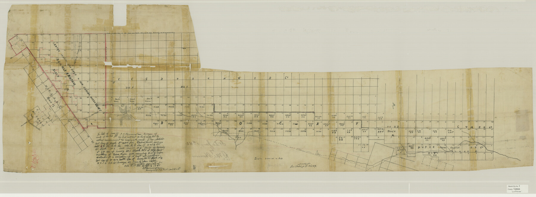
Upton County Sketch File 1
D.L. Cunningham's sk. In Old Tom Green Co.
-
Map/Doc
10412
-
Collection
General Map Collection
-
Object Dates
1881/12/6 (Creation Date)
1882/1/11 (File Date)
1881/12/6 (Creation Date)
-
People and Organizations
D.L. Cunningham (Surveyor/Engineer)
-
Counties
Upton
-
Subjects
Surveying Sketch File
-
Height x Width
24.1 x 65.4 inches
61.2 x 166.1 cm
-
Medium
paper, manuscript
-
Features
Big Shrig [?] Road
Horsehead and Centralia Road
Horsehead Crossing
China Pond
Part of: General Map Collection
Robertson County Working Sketch 16

Print $20.00
- Digital $50.00
Robertson County Working Sketch 16
Size 21.7 x 33.0 inches
Map/Doc 63589
Fort Bend County Sketch File 35

Print $4.00
- Digital $50.00
Fort Bend County Sketch File 35
Size 11.5 x 7.3 inches
Map/Doc 23005
[Surveys near Hondo Creek]
![226, [Surveys near Hondo Creek], General Map Collection](https://historictexasmaps.com/wmedia_w700/maps/226.tif.jpg)
Print $2.00
- Digital $50.00
[Surveys near Hondo Creek]
1847
Size 13.8 x 8.0 inches
Map/Doc 226
Flight Mission No. DAG-14K, Frame 140, Matagorda County

Print $20.00
- Digital $50.00
Flight Mission No. DAG-14K, Frame 140, Matagorda County
1952
Size 17.6 x 17.6 inches
Map/Doc 86307
Goliad County Working Sketch 23

Print $20.00
- Digital $50.00
Goliad County Working Sketch 23
1979
Size 26.8 x 32.9 inches
Map/Doc 63213
Waller County Working Sketch 3

Print $20.00
- Digital $50.00
Waller County Working Sketch 3
1959
Size 35.4 x 28.8 inches
Map/Doc 72302
Lampasas County Boundary File 2a

Print $8.00
- Digital $50.00
Lampasas County Boundary File 2a
Size 14.3 x 8.6 inches
Map/Doc 56097
Flight Mission No. BRA-8M, Frame 66, Jefferson County

Print $20.00
- Digital $50.00
Flight Mission No. BRA-8M, Frame 66, Jefferson County
1953
Size 18.6 x 22.1 inches
Map/Doc 85586
El Paso County Sketch File 26

Print $20.00
- Digital $50.00
El Paso County Sketch File 26
Size 24.8 x 21.9 inches
Map/Doc 11457
Presidio County Sketch File S

Print $27.00
- Digital $50.00
Presidio County Sketch File S
1917
Size 14.3 x 8.8 inches
Map/Doc 34561
Jeff Davis County Sketch File 9

Print $40.00
- Digital $50.00
Jeff Davis County Sketch File 9
Size 15.1 x 17.6 inches
Map/Doc 27920
Collingsworth County

Print $20.00
- Digital $50.00
Collingsworth County
1971
Size 42.5 x 36.2 inches
Map/Doc 73111
You may also like
Western Territories of the United States

Print $20.00
- Digital $50.00
Western Territories of the United States
1847
Size 12.1 x 19.0 inches
Map/Doc 93543
The Pringle and Grieve Colony. November 1, 1843

Print $20.00
The Pringle and Grieve Colony. November 1, 1843
2020
Size 23.0 x 17.7 inches
Map/Doc 96371
Kenedy County Rolled Sketch 8

Print $20.00
- Digital $50.00
Kenedy County Rolled Sketch 8
1915
Size 19.0 x 30.6 inches
Map/Doc 6468
Fisher County Sketch File 20

Print $66.00
- Digital $50.00
Fisher County Sketch File 20
Size 9.3 x 9.1 inches
Map/Doc 22616
Flight Mission No. CGI-4N, Frame 177, Cameron County

Print $20.00
- Digital $50.00
Flight Mission No. CGI-4N, Frame 177, Cameron County
1955
Size 18.5 x 22.2 inches
Map/Doc 84680
Map of the Surveyed Part of Young District

Print $40.00
- Digital $50.00
Map of the Surveyed Part of Young District
1860
Size 56.3 x 27.3 inches
Map/Doc 87374
Kendall County Sketch File 17

Print $4.00
- Digital $50.00
Kendall County Sketch File 17
1878
Size 9.1 x 7.6 inches
Map/Doc 28709

Flight Mission No. DIX-5P, Frame 113, Aransas County

Print $20.00
- Digital $50.00
Flight Mission No. DIX-5P, Frame 113, Aransas County
1956
Size 17.6 x 17.7 inches
Map/Doc 83792
Presidio County Working Sketch 132

Print $20.00
- Digital $50.00
Presidio County Working Sketch 132
1989
Size 36.7 x 29.4 inches
Map/Doc 71810
Coast Chart No. 212 - From Latitude 26° 33' to the Rio Grande Texas

Print $20.00
- Digital $50.00
Coast Chart No. 212 - From Latitude 26° 33' to the Rio Grande Texas
1886
Size 27.4 x 18.2 inches
Map/Doc 72829
Geographically Correct Map of United States showing the Union Pacific System - Union Pacific R.R. Co., Oregon Short Line R.R. Co., Oregon-Washington R.R. & Nav. Co., Los Angeles & Salt Lake R.R. Co., St. Joseph & Grand Island Ry. Co. and connections

Print $20.00
- Digital $50.00
Geographically Correct Map of United States showing the Union Pacific System - Union Pacific R.R. Co., Oregon Short Line R.R. Co., Oregon-Washington R.R. & Nav. Co., Los Angeles & Salt Lake R.R. Co., St. Joseph & Grand Island Ry. Co. and connections
1922
Size 18.2 x 32.2 inches
Map/Doc 95771