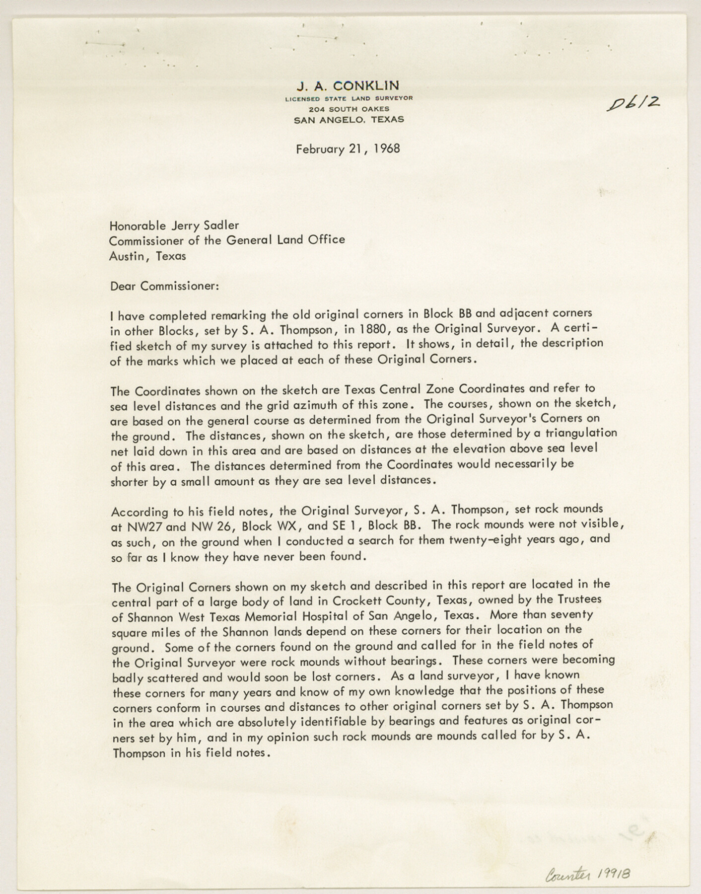
Crockett County Sketch File 91
[Sketch and surveyor's report establishing corners]
-
Map/Doc
19918
-
Collection
General Map Collection
-
Object Dates
1968/2/21 (Creation Date)
1968/7/2 (File Date)
1880 (Survey Date)
1907 (Survey Date)
1923 (Survey Date)
-
People and Organizations
J.A. Conklin (Surveyor/Engineer)
S.A. Thompson (Surveyor/Engineer)
W.P. Conklin (Surveyor/Engineer)
Frank F. Friend (Surveyor/Engineer)
Edgar C. Saunders (Surveyor/Engineer)
J.A. Conklin (Chainman)
Gibbons Poteet (Chainman)
-
Counties
Crockett
-
Subjects
Surveying Sketch File
-
Height x Width
11.3 x 8.8 inches
28.7 x 22.4 cm
-
Medium
multi-page, multi-format
-
Scale
1:1000; 1:500
-
Features
Howard's Creek
World Well #1
World Well #2
Leon Powell Water Well
Part of: General Map Collection

McCulloch County Rolled Sketch 6

Print $20.00
- Digital $50.00
McCulloch County Rolled Sketch 6
1982
Size 27.9 x 33.9 inches
Map/Doc 6717
DeWitt County Working Sketch 1

Print $20.00
- Digital $50.00
DeWitt County Working Sketch 1
1937
Size 24.2 x 30.8 inches
Map/Doc 68591
Jim Hogg County Rolled Sketch 9

Print $20.00
- Digital $50.00
Jim Hogg County Rolled Sketch 9
1974
Size 18.2 x 19.8 inches
Map/Doc 6443
Travis County Appraisal District Plat Map 1_1808

Print $20.00
- Digital $50.00
Travis County Appraisal District Plat Map 1_1808
Size 21.5 x 26.5 inches
Map/Doc 94214
Flight Mission No. DCL-6C, Frame 52, Kenedy County

Print $20.00
- Digital $50.00
Flight Mission No. DCL-6C, Frame 52, Kenedy County
1943
Size 18.6 x 22.4 inches
Map/Doc 85894
La Salle County

Print $20.00
- Digital $50.00
La Salle County
1923
Size 39.7 x 34.5 inches
Map/Doc 77348
Uvalde County Sketch File 31

Print $4.00
- Digital $50.00
Uvalde County Sketch File 31
Size 11.2 x 8.8 inches
Map/Doc 81529

Flight Mission No. CGI-1N, Frame 140, Cameron County

Print $20.00
- Digital $50.00
Flight Mission No. CGI-1N, Frame 140, Cameron County
1955
Size 18.7 x 22.3 inches
Map/Doc 84496
Andrews County Sketch File 2

Print $40.00
- Digital $50.00
Andrews County Sketch File 2
1902
Size 20.7 x 29.5 inches
Map/Doc 10807
Flight Mission No. DQN-3K, Frame 70, Calhoun County

Print $20.00
- Digital $50.00
Flight Mission No. DQN-3K, Frame 70, Calhoun County
1953
Size 18.6 x 22.5 inches
Map/Doc 84361
You may also like
Harris County Sketch File 70

Print $12.00
- Digital $50.00
Harris County Sketch File 70
1938
Size 11.3 x 8.8 inches
Map/Doc 25518
[Grid Map Showing Texas, Louisiana, Arkansas, Mississippi and portions of New Mexico, Oklahoma and Tennessee]
![4668, [Grid Map Showing Texas, Louisiana, Arkansas, Mississippi and portions of New Mexico, Oklahoma and Tennessee], General Map Collection](https://historictexasmaps.com/wmedia_w700/maps/4668.tif.jpg)
Print $20.00
- Digital $50.00
[Grid Map Showing Texas, Louisiana, Arkansas, Mississippi and portions of New Mexico, Oklahoma and Tennessee]
1940
Size 36.4 x 47.3 inches
Map/Doc 4668
General Highway Map, Maverick County, Texas

Print $20.00
General Highway Map, Maverick County, Texas
1961
Size 18.2 x 24.6 inches
Map/Doc 79587
Gaines County Sketch File 17

Print $32.00
- Digital $50.00
Gaines County Sketch File 17
1962
Size 11.3 x 8.8 inches
Map/Doc 23204
PSL Field Notes for Blocks 99, 100, 101, 103, 104, 105, 106, 107, 108, and 109 in Culberson County

PSL Field Notes for Blocks 99, 100, 101, 103, 104, 105, 106, 107, 108, and 109 in Culberson County
Map/Doc 81665
Sketch Richland Creek, Robertson Co.

Print $2.00
- Digital $50.00
Sketch Richland Creek, Robertson Co.
Size 10.4 x 7.9 inches
Map/Doc 266
Navarro County Working Sketch 4

Print $20.00
- Digital $50.00
Navarro County Working Sketch 4
1922
Size 20.8 x 20.9 inches
Map/Doc 71234
Jefferson County Rolled Sketch 6

Print $20.00
- Digital $50.00
Jefferson County Rolled Sketch 6
1916
Size 34.2 x 36.7 inches
Map/Doc 9271
Stephens County Working Sketch 41

Print $40.00
- Digital $50.00
Stephens County Working Sketch 41
2008
Size 34.1 x 48.0 inches
Map/Doc 88737
[C. C. S. D. & R. G. N. G Ry. Co. Block in NW of County]
![90821, [C. C. S. D. & R. G. N. G Ry. Co. Block in NW of County], Twichell Survey Records](https://historictexasmaps.com/wmedia_w700/maps/90821-2.tif.jpg)
Print $20.00
- Digital $50.00
[C. C. S. D. & R. G. N. G Ry. Co. Block in NW of County]
Size 17.3 x 22.0 inches
Map/Doc 90821
Dimmit County Sketch File 34

Print $4.00
- Digital $50.00
Dimmit County Sketch File 34
1884
Size 9.0 x 8.7 inches
Map/Doc 21153
Austin County Sketch File 18

Print $14.00
- Digital $50.00
Austin County Sketch File 18
Size 12.8 x 8.2 inches
Map/Doc 13927