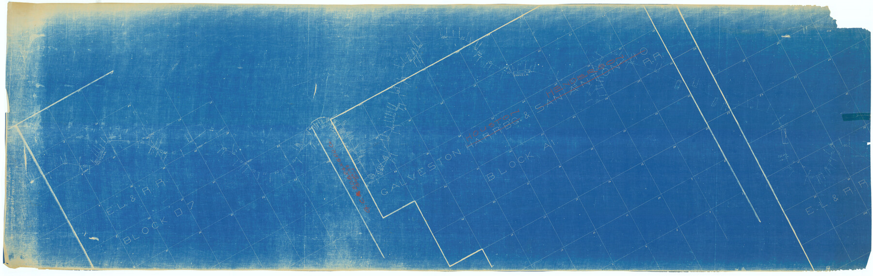
Val Verde County Rolled Sketch 40
[Sketch of part of Block D7, E. L. & R. R. R.R. Co. and Block A1, G. H. & H. R.R. Co., Val Verde & Terrell Counties, Texas]
-
Map/Doc
10073
-
Collection
General Map Collection
-
Object Dates
1912/11/21 (File Date)
-
Counties
Val Verde Terrell
-
Subjects
Surveying Rolled Sketch
-
Height x Width
39.0 x 123.5 inches
99.1 x 313.7 cm
-
Medium
blueprint/diazo
Part of: General Map Collection
Flight Mission No. DCL-6C, Frame 21, Kenedy County

Print $20.00
- Digital $50.00
Flight Mission No. DCL-6C, Frame 21, Kenedy County
1943
Size 18.7 x 22.5 inches
Map/Doc 85878
Galveston County Sketch File 8a

Print $6.00
- Digital $50.00
Galveston County Sketch File 8a
1861
Size 12.1 x 11.8 inches
Map/Doc 23367
Traveller's Map of the State of Texas

Print $20.00
- Digital $50.00
Traveller's Map of the State of Texas
1867
Size 40.6 x 38.2 inches
Map/Doc 4327
Culberson County Working Sketch 23

Print $20.00
- Digital $50.00
Culberson County Working Sketch 23
1945
Size 38.3 x 44.7 inches
Map/Doc 68476
Hemphill County Boundary File 2

Print $54.00
- Digital $50.00
Hemphill County Boundary File 2
Size 8.6 x 32.1 inches
Map/Doc 54621
Nueces County NRC Article 33.136 Sketch 17

Print $26.00
- Digital $50.00
Nueces County NRC Article 33.136 Sketch 17
2013
Size 18.0 x 24.0 inches
Map/Doc 94487
Lampasas County Rolled Sketch 2

Print $20.00
- Digital $50.00
Lampasas County Rolled Sketch 2
Size 21.0 x 39.2 inches
Map/Doc 6565
Trinity County Sketch File 10

Print $8.00
- Digital $50.00
Trinity County Sketch File 10
1858
Size 13.1 x 8.0 inches
Map/Doc 38527
Cherokee County Sketch File 27

Print $4.00
- Digital $50.00
Cherokee County Sketch File 27
1852
Size 8.3 x 8.2 inches
Map/Doc 18171
[Surveys along the San Marcos River]
![158, [Surveys along the San Marcos River], General Map Collection](https://historictexasmaps.com/wmedia_w700/maps/158.tif.jpg)
Print $2.00
- Digital $50.00
[Surveys along the San Marcos River]
Size 7.7 x 5.8 inches
Map/Doc 158
Sutton County Working Sketch 68

Print $40.00
- Digital $50.00
Sutton County Working Sketch 68
1972
Size 61.2 x 37.4 inches
Map/Doc 62411
Clay County Boundary File 4

Print $14.00
- Digital $50.00
Clay County Boundary File 4
Size 10.1 x 6.7 inches
Map/Doc 51366
You may also like
The Coast of Texas

Print $20.00
- Digital $50.00
The Coast of Texas
1844
Size 18.3 x 26.9 inches
Map/Doc 72698
Map of the Recognised Line, M. El. P. & P. RR. from Texas & Arkansas State Line to Milam & Bexar Land District Line

Print $40.00
- Digital $50.00
Map of the Recognised Line, M. El. P. & P. RR. from Texas & Arkansas State Line to Milam & Bexar Land District Line
Size 15.3 x 89.4 inches
Map/Doc 64638
Bee County Working Sketch 8

Print $20.00
- Digital $50.00
Bee County Working Sketch 8
1939
Size 18.0 x 20.5 inches
Map/Doc 67258
Flight Mission No. DCL-6C, Frame 128, Kenedy County

Print $20.00
- Digital $50.00
Flight Mission No. DCL-6C, Frame 128, Kenedy County
1943
Size 18.6 x 22.3 inches
Map/Doc 85958
Wharton County Working Sketch 6

Print $20.00
- Digital $50.00
Wharton County Working Sketch 6
1990
Size 24.7 x 21.1 inches
Map/Doc 72470
Cameron County

Print $20.00
- Digital $50.00
Cameron County
1913
Size 28.9 x 32.1 inches
Map/Doc 4752
General Highway Map. Detail of Cities and Towns in Williamson County, Texas [Round Rock, Taylor, Georgetown]
![79714, General Highway Map. Detail of Cities and Towns in Williamson County, Texas [Round Rock, Taylor, Georgetown], Texas State Library and Archives](https://historictexasmaps.com/wmedia_w700/maps/79714.tif.jpg)
Print $20.00
General Highway Map. Detail of Cities and Towns in Williamson County, Texas [Round Rock, Taylor, Georgetown]
1961
Size 18.2 x 24.8 inches
Map/Doc 79714
Brewster County Sketch File S-1

Print $10.00
- Digital $50.00
Brewster County Sketch File S-1
1921
Size 13.3 x 8.8 inches
Map/Doc 15726
Flight Mission No. CRC-3R, Frame 105, Chambers County

Print $20.00
- Digital $50.00
Flight Mission No. CRC-3R, Frame 105, Chambers County
1956
Size 18.8 x 22.4 inches
Map/Doc 84843
Dickens County Working Sketch 9

Print $20.00
- Digital $50.00
Dickens County Working Sketch 9
1947
Size 18.5 x 29.6 inches
Map/Doc 68657
Lampasas County Sketch File 3

Print $4.00
- Digital $50.00
Lampasas County Sketch File 3
1856
Size 12.1 x 7.6 inches
Map/Doc 29392
Brazos River, Brazos River Sheet 8

Print $4.00
- Digital $50.00
Brazos River, Brazos River Sheet 8
1926
Size 22.6 x 29.2 inches
Map/Doc 65301