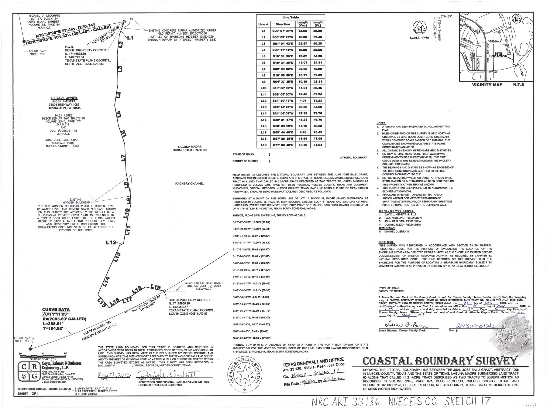
Nueces County NRC Article 33.136 Sketch 17
Coastal Boundary Survey showing the littoral boundary line between the Juan Jose Balli grant, Abstract 1998 in Nueces County, Texas and the State of Texas, Laguna Madre Submerged Land Tract 60 along that called 44.21 acre tract…
-
Map/Doc
94487
-
Collection
General Map Collection
-
Object Dates
2013/5/21 (Creation Date)
2018/4/17 (File Date)
-
People and Organizations
David L. Nesbitt (Surveyor/Engineer)
-
Counties
Nueces
-
Subjects
Surveying CBS
-
Height x Width
18.0 x 24.0 inches
45.7 x 61.0 cm
-
Medium
multi-page, multi-format
-
Comments
Project: Tortuga Harbor Project No.: LC20130003 (GLO)
Part of: General Map Collection
Crockett County Rolled Sketch 28

Print $20.00
- Digital $50.00
Crockett County Rolled Sketch 28
1884
Size 42.5 x 25.8 inches
Map/Doc 5587
Johnson County Working Sketch 20

Print $20.00
- Digital $50.00
Johnson County Working Sketch 20
1991
Size 23.4 x 29.0 inches
Map/Doc 66633
Jack County Working Sketch 22

Print $20.00
- Digital $50.00
Jack County Working Sketch 22
1995
Size 23.9 x 36.7 inches
Map/Doc 66448
Irion County Working Sketch 17

Print $20.00
- Digital $50.00
Irion County Working Sketch 17
1983
Size 37.4 x 41.6 inches
Map/Doc 66426
United States - Gulf Coast Texas - Southern part of Laguna Madre

Print $20.00
- Digital $50.00
United States - Gulf Coast Texas - Southern part of Laguna Madre
1933
Size 26.9 x 18.3 inches
Map/Doc 72952
Flight Mission No. CGI-2N, Frame 152, Cameron County

Print $20.00
- Digital $50.00
Flight Mission No. CGI-2N, Frame 152, Cameron County
1954
Size 18.7 x 22.1 inches
Map/Doc 84534
Donley County Rolled Sketch 3

Print $20.00
- Digital $50.00
Donley County Rolled Sketch 3
1946
Size 15.1 x 21.9 inches
Map/Doc 5729
Boundary Between the United States & Mexico Agreed Upon by the Joint Commission under the Treaty of Guadalupe Hidalgo

Print $4.00
- Digital $50.00
Boundary Between the United States & Mexico Agreed Upon by the Joint Commission under the Treaty of Guadalupe Hidalgo
1853
Size 24.4 x 18.8 inches
Map/Doc 65395
Hall County Sketch File 4

Print $6.00
- Digital $50.00
Hall County Sketch File 4
Size 14.2 x 9.3 inches
Map/Doc 24800
Tarrant County Boundary File 1

Print $20.00
- Digital $50.00
Tarrant County Boundary File 1
Size 9.2 x 34.6 inches
Map/Doc 59110
Terrell County Sketch File 38

Print $6.00
- Digital $50.00
Terrell County Sketch File 38
1987
Size 11.3 x 8.8 inches
Map/Doc 38001
Real County Working Sketch 82

Print $20.00
- Digital $50.00
Real County Working Sketch 82
1985
Size 24.9 x 23.5 inches
Map/Doc 71974
You may also like
Cameron County Rolled Sketch 18

Print $64.00
- Digital $50.00
Cameron County Rolled Sketch 18
1970
Size 48.9 x 57.1 inches
Map/Doc 8571
Webb County Sketch File C

Print $10.00
- Digital $50.00
Webb County Sketch File C
1915
Size 14.4 x 8.8 inches
Map/Doc 39668
Hays County Rolled Sketch 24

Print $20.00
- Digital $50.00
Hays County Rolled Sketch 24
1924
Size 18.4 x 20.9 inches
Map/Doc 6180
[Map of California and Nevada]
![96620, [Map of California and Nevada], Cobb Digital Map Collection](https://historictexasmaps.com/wmedia_w700/maps/96620.tif.jpg)
Print $20.00
- Digital $50.00
[Map of California and Nevada]
1869
Size 9.1 x 10.6 inches
Map/Doc 96620
Sterling County Rolled Sketch 14

Print $20.00
- Digital $50.00
Sterling County Rolled Sketch 14
Size 22.3 x 26.6 inches
Map/Doc 7848
Concho County Rolled Sketch 17

Print $20.00
- Digital $50.00
Concho County Rolled Sketch 17
1961
Size 35.2 x 26.5 inches
Map/Doc 78462
Jackson County NRC Article 33.136 Sketch 1

Print $66.00
- Digital $50.00
Jackson County NRC Article 33.136 Sketch 1
2013
Size 34.0 x 22.0 inches
Map/Doc 94950
Kerr County Rolled Sketch 25

Print $20.00
- Digital $50.00
Kerr County Rolled Sketch 25
Size 24.7 x 31.0 inches
Map/Doc 6505
[Missouri, Kansas & Texas Line Map through Bastrop County]
![64028, [Missouri, Kansas & Texas Line Map through Bastrop County], General Map Collection](https://historictexasmaps.com/wmedia_w700/maps/64028.tif.jpg)
Print $40.00
- Digital $50.00
[Missouri, Kansas & Texas Line Map through Bastrop County]
1916
Size 26.2 x 121.8 inches
Map/Doc 64028
![90967, [Survey 12], Twichell Survey Records](https://historictexasmaps.com/wmedia_w700/maps/90967-1.tif.jpg)
Cass County Working Sketch 5
Print $20.00
- Digital $50.00
Cass County Working Sketch 5
1936
Size 45.6 x 43.1 inches
Map/Doc 67908
[H. & T. C. RR. Company, Block 47, Map C]
![91247, [H. & T. C. RR. Company, Block 47, Map C], Twichell Survey Records](https://historictexasmaps.com/wmedia_w700/maps/91247-1.tif.jpg)
Print $20.00
- Digital $50.00
[H. & T. C. RR. Company, Block 47, Map C]
Size 32.6 x 19.9 inches
Map/Doc 91247