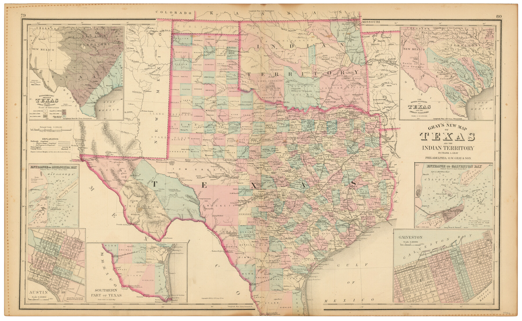
Gray's New Map of Texas and the Indian Territory
-
Map/Doc
97282
-
Collection
General Map Collection
-
Object Dates
1876 (Creation Date)
-
People and Organizations
Frank A. Gray (Cartographer)
O.W. Gray & Son (Publisher)
Chase Untermeyer (Donor)
-
Subjects
State of Texas
-
Height x Width
17.6 x 28.6 inches
44.7 x 72.6 cm
-
Comments
Donated by Ambassador Chase Untermeyer in June 2024.
Part of: General Map Collection
Lampasas County Sketch File B

Print $20.00
- Digital $50.00
Lampasas County Sketch File B
1886
Size 15.0 x 22.4 inches
Map/Doc 11977
Eastland County Working Sketch 47

Print $20.00
- Digital $50.00
Eastland County Working Sketch 47
1981
Size 30.0 x 27.1 inches
Map/Doc 68828
Lampasas County Sketch File 15

Print $20.00
- Digital $50.00
Lampasas County Sketch File 15
1888
Size 24.5 x 27.1 inches
Map/Doc 11975
Presidio County Sketch File 120

Print $16.00
- Digital $50.00
Presidio County Sketch File 120
Size 14.2 x 8.8 inches
Map/Doc 34934
Lampasas County Sketch File 10

Print $8.00
- Digital $50.00
Lampasas County Sketch File 10
1872
Size 12.7 x 7.9 inches
Map/Doc 29416
Calhoun County Rolled Sketch 11

Print $20.00
- Digital $50.00
Calhoun County Rolled Sketch 11
1942
Size 12.8 x 41.9 inches
Map/Doc 5368
Harris County Working Sketch 121

Print $20.00
- Digital $50.00
Harris County Working Sketch 121
1985
Size 34.4 x 18.6 inches
Map/Doc 66013
Presidio County Sketch File 104

Print $17.00
- Digital $50.00
Presidio County Sketch File 104
Size 11.3 x 8.7 inches
Map/Doc 34807
Aransas County Sketch File 6

Print $4.00
- Digital $50.00
Aransas County Sketch File 6
Size 8.2 x 10.7 inches
Map/Doc 13110
[Sketch for Mineral Application 24072, San Jacinto River]
![65585, [Sketch for Mineral Application 24072, San Jacinto River], General Map Collection](https://historictexasmaps.com/wmedia_w700/maps/65585.tif.jpg)
Print $20.00
- Digital $50.00
[Sketch for Mineral Application 24072, San Jacinto River]
1929
Size 21.7 x 11.1 inches
Map/Doc 65585
Scurry County Rolled Sketch 3

Print $40.00
- Digital $50.00
Scurry County Rolled Sketch 3
Size 50.2 x 46.7 inches
Map/Doc 9912
Concho County Working Sketch 24

Print $20.00
- Digital $50.00
Concho County Working Sketch 24
1981
Size 35.0 x 44.2 inches
Map/Doc 68206
You may also like
El Paso County Rolled Sketch 57B

Print $40.00
- Digital $50.00
El Paso County Rolled Sketch 57B
1984
Size 49.0 x 37.1 inches
Map/Doc 8880
Motley County Sketch File 1 (S)

Print $22.00
- Digital $50.00
Motley County Sketch File 1 (S)
1879
Size 9.0 x 14.3 inches
Map/Doc 32139
This is a true copy of Peck's field book No. 7 pages 28 to 35, except classification of land

Print $40.00
- Digital $50.00
This is a true copy of Peck's field book No. 7 pages 28 to 35, except classification of land
Size 5.7 x 68.2 inches
Map/Doc 89728
Maps of Gulf Intracoastal Waterway, Texas - Sabine River to the Rio Grande and connecting waterways including ship channels

Print $20.00
- Digital $50.00
Maps of Gulf Intracoastal Waterway, Texas - Sabine River to the Rio Grande and connecting waterways including ship channels
1966
Size 14.6 x 20.5 inches
Map/Doc 61991
Roberts County Working Sketch 32

Print $20.00
- Digital $50.00
Roberts County Working Sketch 32
1978
Size 26.6 x 22.5 inches
Map/Doc 63558
El Paso County Working Sketch 51

Print $20.00
- Digital $50.00
El Paso County Working Sketch 51
1992
Size 19.7 x 13.0 inches
Map/Doc 69073
Map of the Fort Worth & Denver City Railway

Print $40.00
- Digital $50.00
Map of the Fort Worth & Denver City Railway
1887
Size 22.8 x 124.4 inches
Map/Doc 64458
Travels to the source of the Missouri River and across the American Continent to the Pacific Ocean - Vol. 2

Travels to the source of the Missouri River and across the American Continent to the Pacific Ocean - Vol. 2
1815
Map/Doc 97413
[Sketch of surveys in Hutchinson County]
![75817, [Sketch of surveys in Hutchinson County], Maddox Collection](https://historictexasmaps.com/wmedia_w700/maps/75817.tif.jpg)
Print $20.00
- Digital $50.00
[Sketch of surveys in Hutchinson County]
1912
Size 25.0 x 26.8 inches
Map/Doc 75817
Armstrong County Sketch File 8

Print $8.00
- Digital $50.00
Armstrong County Sketch File 8
Size 14.2 x 8.8 inches
Map/Doc 13705
New Map of State of Texas

Print $20.00
- Digital $50.00
New Map of State of Texas
1881
Size 21.4 x 27.6 inches
Map/Doc 460
Cameron County Rolled Sketch 18

Print $64.00
- Digital $50.00
Cameron County Rolled Sketch 18
1970
Size 48.9 x 57.1 inches
Map/Doc 8571