The Republic County of Sabine. Boundaries Defined, December14, 1837

Print $20.00
The Republic County of Sabine. Boundaries Defined, December14, 1837
2020
Size: 17.6 x 21.7 inches
96269
The Republic County of Sabine. December 29, 1845

Print $20.00
The Republic County of Sabine. December 29, 1845
2020
Size: 17.6 x 21.7 inches
96270
San Augustine County Sketch File 23

Print $12.00
San Augustine County Sketch File 23
1992
Size: 14.5 x 9.0 inches
35689
Sabine County Working Sketch 16

Print $20.00
- Digital $50.00
Sabine County Working Sketch 16
1984
Size: 26.0 x 29.8 inches
63687
Newton County Working Sketch 35

Print $20.00
- Digital $50.00
Newton County Working Sketch 35
1969
Size: 37.4 x 32.3 inches
71281
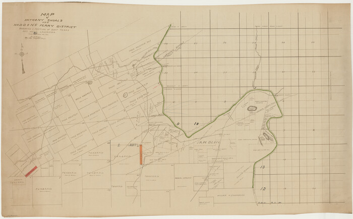
General Highway Map, Sabine County, Texas

Print $20.00
General Highway Map, Sabine County, Texas
1961
Size: 24.6 x 18.1 inches
79644
Sabine County Rolled Sketch 1

Print $20.00
- Digital $50.00
Sabine County Rolled Sketch 1
1958
Size: 36.5 x 41.3 inches
9879
Sabine County Working Sketch 15

Print $20.00
- Digital $50.00
Sabine County Working Sketch 15
1957
Size: 21.2 x 34.9 inches
63686
Sabine County Working Sketch 14

Print $20.00
- Digital $50.00
Sabine County Working Sketch 14
1953
Size: 29.3 x 38.6 inches
63685
Sabine County Rolled Sketch 2

Print $20.00
- Digital $50.00
Sabine County Rolled Sketch 2
1949
Size: 33.3 x 20.8 inches
7551
General Highway Map, Sabine County, Texas

Print $20.00
General Highway Map, Sabine County, Texas
1940
Size: 24.7 x 18.3 inches
79233
General Highway Map, Sabine County, Texas

Print $20.00
General Highway Map, Sabine County, Texas
1940
Size: 24.9 x 18.4 inches
79234
Sabine County Working Sketch 13

Print $20.00
- Digital $50.00
Sabine County Working Sketch 13
1935
Size: 35.3 x 44.2 inches
63684
Sabine County Working Sketch 12

Print $20.00
- Digital $50.00
Sabine County Working Sketch 12
1935
Size: 39.2 x 45.9 inches
63683
Sabine County Working Sketch 11

Print $20.00
- Digital $50.00
Sabine County Working Sketch 11
1931
Size: 30.9 x 34.0 inches
63682
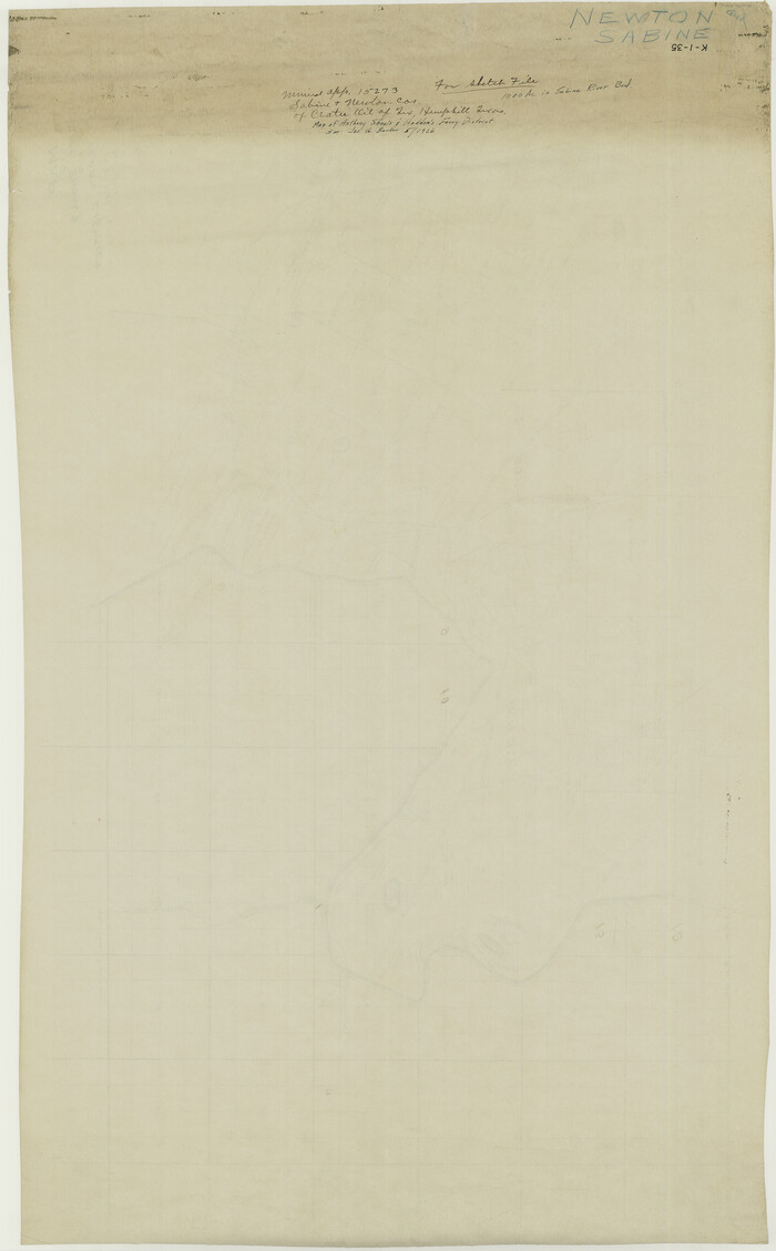
[Sketch for Mineral Application 15273 - Sabine River Bed]
Print $20.00
- Digital $50.00
[Sketch for Mineral Application 15273 - Sabine River Bed]
1926
Size: 28.2 x 45.5 inches
65575
[Sketch for Mineral Application 15273 - Sabine River Bed]
Print $20.00
- Digital $50.00
[Sketch for Mineral Application 15273 - Sabine River Bed]
1926
Size: 45.4 x 28.1 inches
65576
Sabine County Working Sketch 10

Print $20.00
- Digital $50.00
Sabine County Working Sketch 10
1925
Size: 18.6 x 24.2 inches
63681
Sabine County Working Sketch 8

Print $20.00
- Digital $50.00
Sabine County Working Sketch 8
1923
Size: 40.8 x 43.5 inches
63679
Sabine County Working Sketch 9

Print $20.00
- Digital $50.00
Sabine County Working Sketch 9
1923
Size: 23.9 x 27.1 inches
63680
Sabine County Working Sketch 1

Print $20.00
- Digital $50.00
Sabine County Working Sketch 1
1922
Size: 17.7 x 17.7 inches
63672
Sabine County Working Sketch 7

Print $20.00
- Digital $50.00
Sabine County Working Sketch 7
1922
Size: 15.3 x 19.4 inches
63678
Sabine County Working Sketch Graphic Index

Print $20.00
- Digital $50.00
Sabine County Working Sketch Graphic Index
1920
Size: 42.4 x 33.1 inches
76689
Sabine County Working Sketch 6

Print $20.00
- Digital $50.00
Sabine County Working Sketch 6
1918
Size: 17.5 x 17.6 inches
63677
Sabine County Working Sketch 5

Print $20.00
- Digital $50.00
Sabine County Working Sketch 5
1918
Size: 17.3 x 17.3 inches
63676
The Republic County of Sabine. Boundaries Defined, December14, 1837
Print $20.00
The Republic County of Sabine. Boundaries Defined, December14, 1837
2020
-
Size
17.6 x 21.7 inches
-
Map/Doc
96269
-
Creation Date
2020
The Republic County of Sabine. December 29, 1845
Print $20.00
The Republic County of Sabine. December 29, 1845
2020
-
Size
17.6 x 21.7 inches
-
Map/Doc
96270
-
Creation Date
2020
San Augustine County Sketch File 23
Print $12.00
San Augustine County Sketch File 23
1992
-
Size
14.5 x 9.0 inches
-
Map/Doc
35689
-
Creation Date
1992
Sabine County Working Sketch 16
Print $20.00
- Digital $50.00
Sabine County Working Sketch 16
1984
-
Size
26.0 x 29.8 inches
-
Map/Doc
63687
-
Creation Date
1984
Newton County Working Sketch 35
Print $20.00
- Digital $50.00
Newton County Working Sketch 35
1969
-
Size
37.4 x 32.3 inches
-
Map/Doc
71281
-
Creation Date
1969
General Highway Map, Sabine County, Texas
Print $20.00
General Highway Map, Sabine County, Texas
1961
-
Size
24.6 x 18.1 inches
-
Map/Doc
79644
-
Creation Date
1961
Sabine County Rolled Sketch 1
Print $20.00
- Digital $50.00
Sabine County Rolled Sketch 1
1958
-
Size
36.5 x 41.3 inches
-
Map/Doc
9879
-
Creation Date
1958
Sabine County Working Sketch 15
Print $20.00
- Digital $50.00
Sabine County Working Sketch 15
1957
-
Size
21.2 x 34.9 inches
-
Map/Doc
63686
-
Creation Date
1957
Sabine County Working Sketch 14
Print $20.00
- Digital $50.00
Sabine County Working Sketch 14
1953
-
Size
29.3 x 38.6 inches
-
Map/Doc
63685
-
Creation Date
1953
Sabine County Rolled Sketch 2
Print $20.00
- Digital $50.00
Sabine County Rolled Sketch 2
1949
-
Size
33.3 x 20.8 inches
-
Map/Doc
7551
-
Creation Date
1949
General Highway Map, Sabine County, Texas
Print $20.00
General Highway Map, Sabine County, Texas
1940
-
Size
24.7 x 18.3 inches
-
Map/Doc
79233
-
Creation Date
1940
General Highway Map, Sabine County, Texas
Print $20.00
General Highway Map, Sabine County, Texas
1940
-
Size
24.9 x 18.4 inches
-
Map/Doc
79234
-
Creation Date
1940
Sabine County Working Sketch 13
Print $20.00
- Digital $50.00
Sabine County Working Sketch 13
1935
-
Size
35.3 x 44.2 inches
-
Map/Doc
63684
-
Creation Date
1935
Sabine County Working Sketch 12
Print $20.00
- Digital $50.00
Sabine County Working Sketch 12
1935
-
Size
39.2 x 45.9 inches
-
Map/Doc
63683
-
Creation Date
1935
Sabine County Working Sketch 11
Print $20.00
- Digital $50.00
Sabine County Working Sketch 11
1931
-
Size
30.9 x 34.0 inches
-
Map/Doc
63682
-
Creation Date
1931
[Sketch for Mineral Application 15273 - Sabine River Bed]
Print $20.00
- Digital $50.00
[Sketch for Mineral Application 15273 - Sabine River Bed]
1926
-
Size
28.2 x 45.5 inches
-
Map/Doc
65575
-
Creation Date
1926
[Sketch for Mineral Application 15273 - Sabine River Bed]
Print $20.00
- Digital $50.00
[Sketch for Mineral Application 15273 - Sabine River Bed]
1926
-
Size
45.4 x 28.1 inches
-
Map/Doc
65576
-
Creation Date
1926
Sabine County Working Sketch 10
Print $20.00
- Digital $50.00
Sabine County Working Sketch 10
1925
-
Size
18.6 x 24.2 inches
-
Map/Doc
63681
-
Creation Date
1925
Sabine County Working Sketch 8
Print $20.00
- Digital $50.00
Sabine County Working Sketch 8
1923
-
Size
40.8 x 43.5 inches
-
Map/Doc
63679
-
Creation Date
1923
Sabine County Working Sketch 9
Print $20.00
- Digital $50.00
Sabine County Working Sketch 9
1923
-
Size
23.9 x 27.1 inches
-
Map/Doc
63680
-
Creation Date
1923
Sabine County Working Sketch 1
Print $20.00
- Digital $50.00
Sabine County Working Sketch 1
1922
-
Size
17.7 x 17.7 inches
-
Map/Doc
63672
-
Creation Date
1922
Sabine County Working Sketch 7
Print $20.00
- Digital $50.00
Sabine County Working Sketch 7
1922
-
Size
15.3 x 19.4 inches
-
Map/Doc
63678
-
Creation Date
1922
Sabine County

Print $20.00
- Digital $50.00
Sabine County
1920
-
Size
44.6 x 35.1 inches
-
Map/Doc
16805
-
Creation Date
1920
Sabine County

Print $20.00
- Digital $50.00
Sabine County
1920
-
Size
43.5 x 34.2 inches
-
Map/Doc
63013
-
Creation Date
1920
Sabine County

Print $20.00
- Digital $50.00
Sabine County
1920
-
Size
43.9 x 34.6 inches
-
Map/Doc
63014
-
Creation Date
1920
Sabine County Working Sketch Graphic Index
Print $20.00
- Digital $50.00
Sabine County Working Sketch Graphic Index
1920
-
Size
42.4 x 33.1 inches
-
Map/Doc
76689
-
Creation Date
1920
Sabine County

Print $20.00
- Digital $50.00
Sabine County
1920
-
Size
45.7 x 36.1 inches
-
Map/Doc
95631
-
Creation Date
1920
Sabine County

Print $20.00
- Digital $50.00
Sabine County
1920
-
Size
41.2 x 31.8 inches
-
Map/Doc
77413
-
Creation Date
1920
Sabine County Working Sketch 6
Print $20.00
- Digital $50.00
Sabine County Working Sketch 6
1918
-
Size
17.5 x 17.6 inches
-
Map/Doc
63677
-
Creation Date
1918
Sabine County Working Sketch 5
Print $20.00
- Digital $50.00
Sabine County Working Sketch 5
1918
-
Size
17.3 x 17.3 inches
-
Map/Doc
63676
-
Creation Date
1918