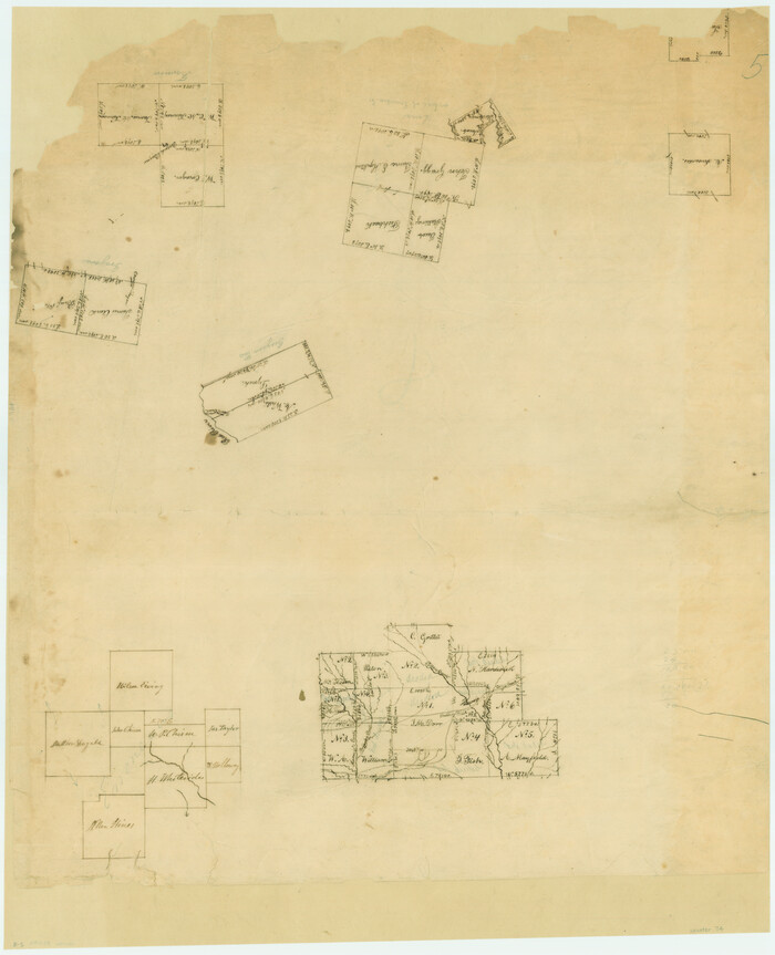
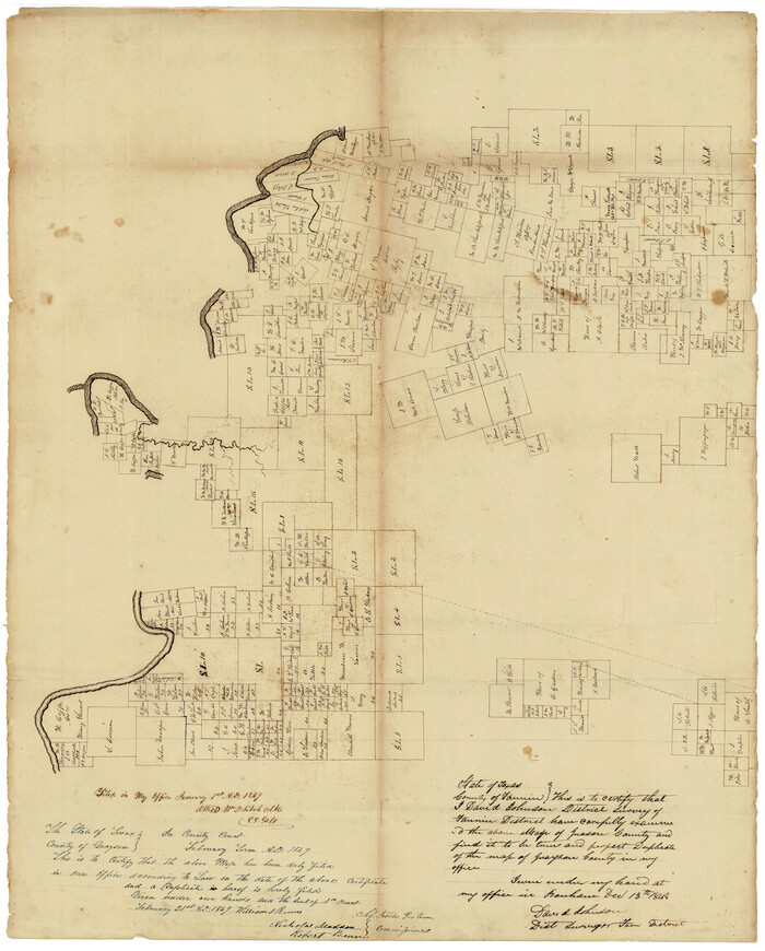
[Surveys along the Red River, Bois d'Arc Creek, Duck Creek, and Choctaw Bayou made under G.W. Smyth, Commissioner]
Print $20.00
- Digital $50.00
[Surveys along the Red River, Bois d'Arc Creek, Duck Creek, and Choctaw Bayou made under G.W. Smyth, Commissioner]
1834
Size: 19.7 x 16.0 inches
74
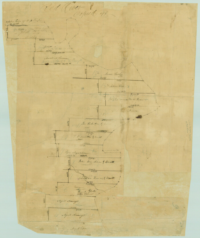
[Surveys along the Red River made for titles under Radford Berry, Commissioner]
Print $20.00
- Digital $50.00
[Surveys along the Red River made for titles under Radford Berry, Commissioner]
Size: 23.3 x 19.5 inches
32
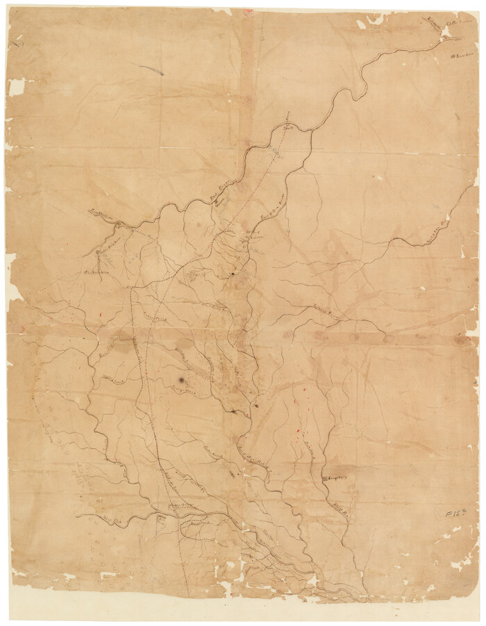
[Sketch of Col. Cooke's Military Road expedition from Red River to Austin]
Print $20.00
- Digital $50.00
[Sketch of Col. Cooke's Military Road expedition from Red River to Austin]
Size: 29.4 x 22.9 inches
166
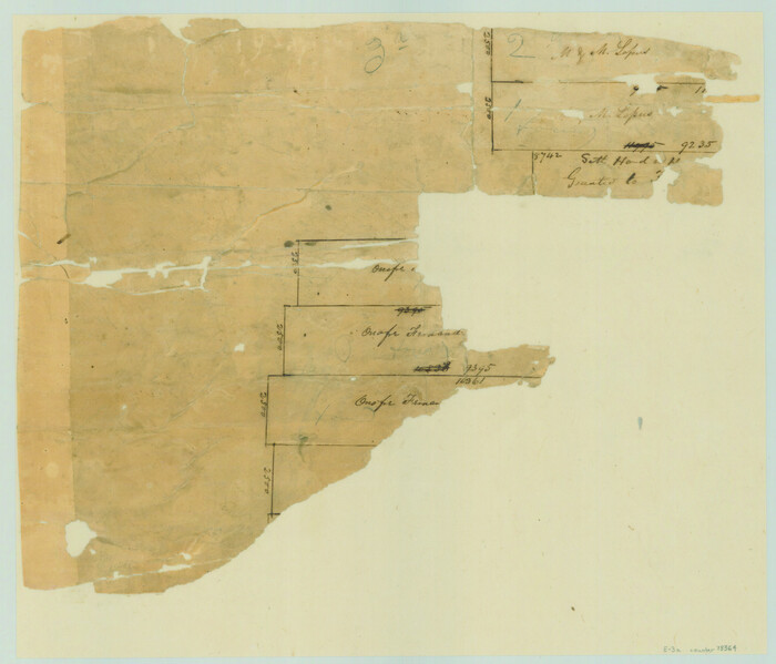
[Northeast portion of Grayson County]
Print $20.00
- Digital $50.00
[Northeast portion of Grayson County]
Size: 12.0 x 14.0 inches
78364
[Map of Grayson County]
Print $20.00
- Digital $50.00
[Map of Grayson County]
1848
Size: 25.6 x 20.0 inches
4551
University and College Lands

Print $20.00
- Digital $50.00
University and College Lands
1841
Size: 21.3 x 27.0 inches
169
University Lands Situated in Robertson County

Print $20.00
- Digital $50.00
University Lands Situated in Robertson County
1841
Size: 22.8 x 26.2 inches
281
University Land in Grayson County in Two Parts

Print $20.00
- Digital $50.00
University Land in Grayson County in Two Parts
Size: 23.9 x 30.4 inches
2429
University Land in Grayson County in Two Parts
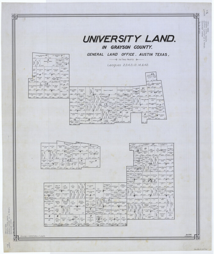
Print $20.00
- Digital $50.00
University Land in Grayson County in Two Parts
Size: 30.6 x 25.8 inches
62965
Trinity River, Watershed

Print $20.00
- Digital $50.00
Trinity River, Watershed
1925
Size: 46.9 x 40.5 inches
65255

Pottsboro Quadrangle

Print $20.00
- Digital $50.00
Pottsboro Quadrangle
1999
Size: 35.4 x 23.4 inches
97363
Platter Quadrangle

Print $20.00
- Digital $50.00
Platter Quadrangle
1999
Size: 35.4 x 23.4 inches
97365
Outline Map of Grayson County Texas

Print $20.00
- Digital $50.00
Outline Map of Grayson County Texas
1913
Size: 19.2 x 16.4 inches
4552
Map of the Recognised Line, M. El. P. & P. RR. from Texas & Arkansas State Line to Milam & Bexar Land District Line

Print $40.00
- Digital $50.00
Map of the Recognised Line, M. El. P. & P. RR. from Texas & Arkansas State Line to Milam & Bexar Land District Line
Size: 15.3 x 89.4 inches
64638
Map of the Lands Surveyed by the Memphis, El Paso & Pacific R.R. Company

Print $20.00
- Digital $50.00
Map of the Lands Surveyed by the Memphis, El Paso & Pacific R.R. Company
1860
Size: 18.6 x 19.0 inches
4846
Map of the Denison & South Eastern Rwy. showing the Location & Land Lines of the First Twenty-One Miles

Print $40.00
- Digital $50.00
Map of the Denison & South Eastern Rwy. showing the Location & Land Lines of the First Twenty-One Miles
1878
Size: 24.1 x 70.4 inches
64023
Map of University Land part of Fifty League Grant Act of 1839

Print $20.00
- Digital $50.00
Map of University Land part of Fifty League Grant Act of 1839
1905
Size: 40.7 x 28.7 inches
2430
Map of The Surveyed Part of Peters Colony Texas

Print $40.00
- Digital $50.00
Map of The Surveyed Part of Peters Colony Texas
1852
Size: 54.0 x 28.8 inches
3155
Map of Main Line Houston & Tex. Centr. Railway from Dallas to Red River City

Print $40.00
- Digital $50.00
Map of Main Line Houston & Tex. Centr. Railway from Dallas to Red River City
Size: 37.1 x 84.9 inches
64089
Map of Grayson County

Print $20.00
- Digital $50.00
Map of Grayson County
1871
Size: 19.5 x 17.8 inches
1088
Map of Grayson County

Print $20.00
- Digital $50.00
Map of Grayson County
1859
Size: 22.6 x 19.5 inches
3600
Map of Fannin County

Print $20.00
- Digital $50.00
Map of Fannin County
1845
Size: 34.7 x 36.5 inches
16827
Map of Fannin County

Print $20.00
- Digital $50.00
Map of Fannin County
1845
Size: 34.7 x 47.0 inches
87153
Map and Profile of the Denison and Pacific Railway from Denison to Whitesboro

Print $40.00
- Digital $50.00
Map and Profile of the Denison and Pacific Railway from Denison to Whitesboro
1878
Size: 42.5 x 57.5 inches
64284
Map Exhibiting the line of the Southern Trans-Continental R.R. from Marshall to Texarkana from Texarkana to Forth Worth

Print $20.00
- Digital $50.00
Map Exhibiting the line of the Southern Trans-Continental R.R. from Marshall to Texarkana from Texarkana to Forth Worth
1872
Size: 24.6 x 47.8 inches
64241
Lebanon Quadrangle

Print $20.00
- Digital $50.00
Lebanon Quadrangle
1999
Size: 35.4 x 23.4 inches
97360
Kingston South Quadrangle

Print $20.00
- Digital $50.00
Kingston South Quadrangle
1999
Size: 35.4 x 23.4 inches
97364
[Surveys along the Red River, Bois d'Arc Creek, Duck Creek, and Choctaw Bayou made under G.W. Smyth, Commissioner]
Print $20.00
- Digital $50.00
[Surveys along the Red River, Bois d'Arc Creek, Duck Creek, and Choctaw Bayou made under G.W. Smyth, Commissioner]
1834
-
Size
19.7 x 16.0 inches
-
Map/Doc
74
-
Creation Date
1834
[Surveys along the Red River made for titles under Radford Berry, Commissioner]
Print $20.00
- Digital $50.00
[Surveys along the Red River made for titles under Radford Berry, Commissioner]
-
Size
23.3 x 19.5 inches
-
Map/Doc
32
[Sketch of Col. Cooke's Military Road expedition from Red River to Austin]
Print $20.00
- Digital $50.00
[Sketch of Col. Cooke's Military Road expedition from Red River to Austin]
-
Size
29.4 x 22.9 inches
-
Map/Doc
166
[Northeast portion of Grayson County]
Print $20.00
- Digital $50.00
[Northeast portion of Grayson County]
-
Size
12.0 x 14.0 inches
-
Map/Doc
78364
[Map of Grayson County]
Print $20.00
- Digital $50.00
[Map of Grayson County]
1848
-
Size
25.6 x 20.0 inches
-
Map/Doc
4551
-
Creation Date
1848
Whitewright, Texas

Print $20.00
Whitewright, Texas
1891
-
Size
14.3 x 24.3 inches
-
Map/Doc
89213
-
Creation Date
1891
University and College Lands
Print $20.00
- Digital $50.00
University and College Lands
1841
-
Size
21.3 x 27.0 inches
-
Map/Doc
169
-
Creation Date
1841
University Lands Situated in Robertson County
Print $20.00
- Digital $50.00
University Lands Situated in Robertson County
1841
-
Size
22.8 x 26.2 inches
-
Map/Doc
281
-
Creation Date
1841
University Land in Grayson County in Two Parts
Print $20.00
- Digital $50.00
University Land in Grayson County in Two Parts
-
Size
23.9 x 30.4 inches
-
Map/Doc
2429
University Land in Grayson County in Two Parts
Print $20.00
- Digital $50.00
University Land in Grayson County in Two Parts
-
Size
30.6 x 25.8 inches
-
Map/Doc
62965
Trinity River, Watershed
Print $20.00
- Digital $50.00
Trinity River, Watershed
1925
-
Size
46.9 x 40.5 inches
-
Map/Doc
65255
-
Creation Date
1925
Texas State Boundary Line 10

Print $50.00
Texas State Boundary Line 10
2024
-
Map/Doc
97431
-
Creation Date
2024
Pottsboro Quadrangle
Print $20.00
- Digital $50.00
Pottsboro Quadrangle
1999
USGS Topo Sheet showing plotted Texoma Area Boundary
-
Size
35.4 x 23.4 inches
-
Map/Doc
97363
-
Creation Date
1999
Platter Quadrangle
Print $20.00
- Digital $50.00
Platter Quadrangle
1999
USGS Topo Sheet showing plotted Texoma Area Boundary
-
Size
35.4 x 23.4 inches
-
Map/Doc
97365
-
Creation Date
1999
Outline Map of Grayson County Texas
Print $20.00
- Digital $50.00
Outline Map of Grayson County Texas
1913
-
Size
19.2 x 16.4 inches
-
Map/Doc
4552
-
Creation Date
1913
Map of the Recognised Line, M. El. P. & P. RR. from Texas & Arkansas State Line to Milam & Bexar Land District Line
Print $40.00
- Digital $50.00
Map of the Recognised Line, M. El. P. & P. RR. from Texas & Arkansas State Line to Milam & Bexar Land District Line
-
Size
15.3 x 89.4 inches
-
Map/Doc
64638
Map of the Lands Surveyed by the Memphis, El Paso & Pacific R.R. Company
Print $20.00
- Digital $50.00
Map of the Lands Surveyed by the Memphis, El Paso & Pacific R.R. Company
1860
-
Size
18.6 x 19.0 inches
-
Map/Doc
4846
-
Creation Date
1860
Map of the Denison & South Eastern Rwy. showing the Location & Land Lines of the First Twenty-One Miles
Print $40.00
- Digital $50.00
Map of the Denison & South Eastern Rwy. showing the Location & Land Lines of the First Twenty-One Miles
1878
-
Size
24.1 x 70.4 inches
-
Map/Doc
64023
-
Creation Date
1878
Map of University Land part of Fifty League Grant Act of 1839
Print $20.00
- Digital $50.00
Map of University Land part of Fifty League Grant Act of 1839
1905
-
Size
40.7 x 28.7 inches
-
Map/Doc
2430
-
Creation Date
1905
Map of The Surveyed Part of Peters Colony Texas
Print $40.00
- Digital $50.00
Map of The Surveyed Part of Peters Colony Texas
1852
-
Size
54.0 x 28.8 inches
-
Map/Doc
3155
-
Creation Date
1852
Map of Main Line Houston & Tex. Centr. Railway from Dallas to Red River City
Print $40.00
- Digital $50.00
Map of Main Line Houston & Tex. Centr. Railway from Dallas to Red River City
-
Size
37.1 x 84.9 inches
-
Map/Doc
64089
Map of Grayson County
Print $20.00
- Digital $50.00
Map of Grayson County
1871
-
Size
19.5 x 17.8 inches
-
Map/Doc
1088
-
Creation Date
1871
Map of Grayson County
Print $20.00
- Digital $50.00
Map of Grayson County
1859
-
Size
22.6 x 19.5 inches
-
Map/Doc
3600
-
Creation Date
1859
Map of Fannin County
Print $20.00
- Digital $50.00
Map of Fannin County
1845
-
Size
34.7 x 36.5 inches
-
Map/Doc
16827
-
Creation Date
1845
Map of Fannin County
Print $20.00
- Digital $50.00
Map of Fannin County
1845
-
Size
34.7 x 47.0 inches
-
Map/Doc
87153
-
Creation Date
1845
Map and Profile of the Denison and Pacific Railway from Denison to Whitesboro
Print $40.00
- Digital $50.00
Map and Profile of the Denison and Pacific Railway from Denison to Whitesboro
1878
-
Size
42.5 x 57.5 inches
-
Map/Doc
64284
-
Creation Date
1878
Map Exhibiting the line of the Southern Trans-Continental R.R. from Marshall to Texarkana from Texarkana to Forth Worth
Print $20.00
- Digital $50.00
Map Exhibiting the line of the Southern Trans-Continental R.R. from Marshall to Texarkana from Texarkana to Forth Worth
1872
-
Size
24.6 x 47.8 inches
-
Map/Doc
64241
-
Creation Date
1872
Lebanon Quadrangle
Print $20.00
- Digital $50.00
Lebanon Quadrangle
1999
USGS Topo Sheet showing plotted Texoma Area Boundary
-
Size
35.4 x 23.4 inches
-
Map/Doc
97360
-
Creation Date
1999
Kingston South Quadrangle
Print $20.00
- Digital $50.00
Kingston South Quadrangle
1999
USGS Topo Sheet showing plotted Texoma Area Boundary
-
Size
35.4 x 23.4 inches
-
Map/Doc
97364
-
Creation Date
1999