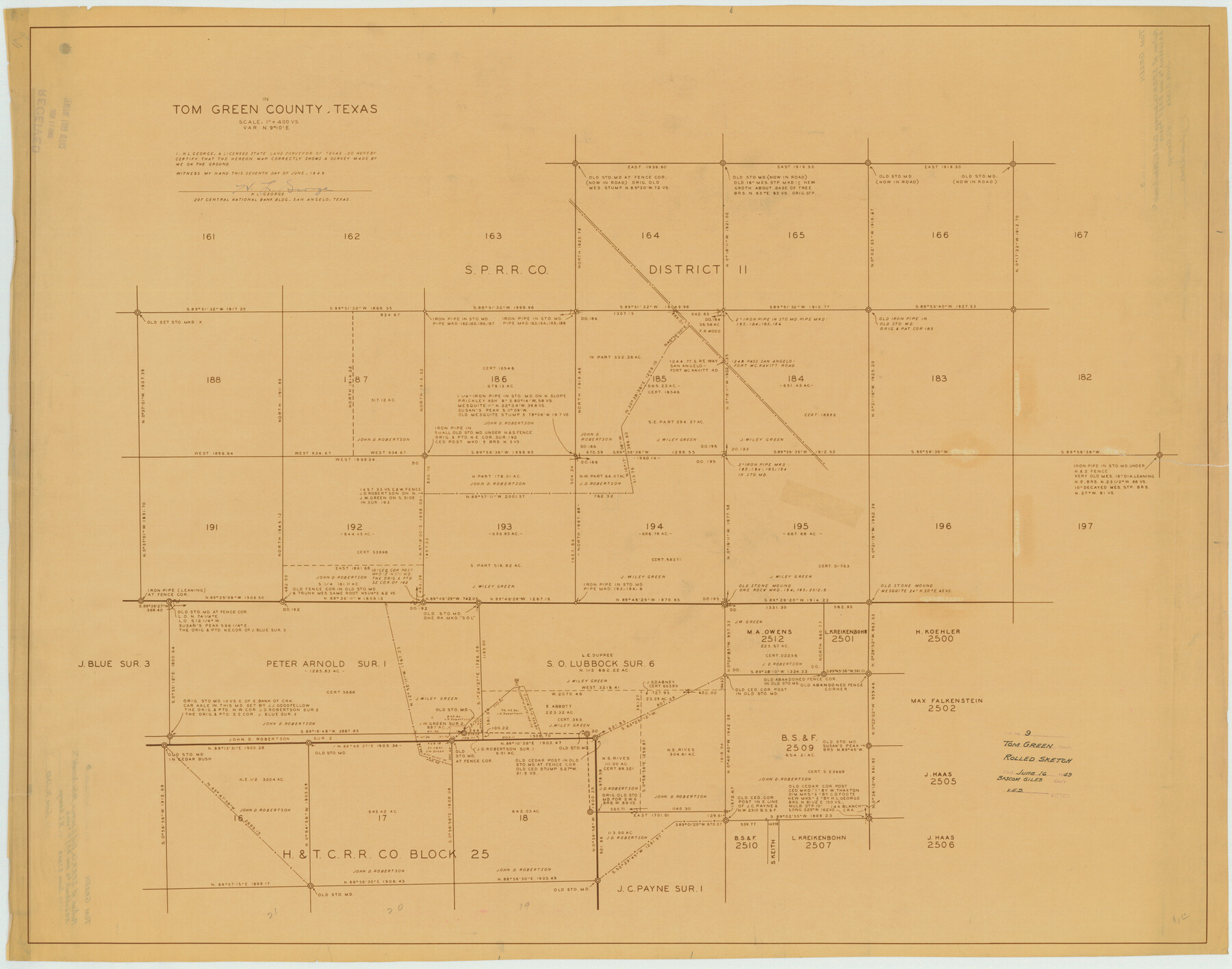
Tom Green County Rolled Sketch 9
[Sketch showing south portion of S. P. R.R. Co. District 11 and surveys to the south]
-
Map/Doc
9999
-
Collection
General Map Collection
-
Object Dates
1949/6/7 (Creation Date)
1949/6/16 (File Date)
-
People and Organizations
H.L. George (Surveyor/Engineer)
-
Counties
Tom Green
-
Subjects
Surveying Rolled Sketch
-
Height x Width
32.2 x 41.0 inches
81.8 x 104.1 cm
-
Medium
van dyke/brownline/sepia
-
Scale
1" = 400 varas
Part of: General Map Collection
Working Sketch of surveys in Brazoria County, showing Cedar Lakes

Print $40.00
- Digital $50.00
Working Sketch of surveys in Brazoria County, showing Cedar Lakes
1950
Size 31.2 x 57.3 inches
Map/Doc 1932
[Surveys in Waller County]
![78367, [Surveys in Waller County], General Map Collection](https://historictexasmaps.com/wmedia_w700/maps/78367.tif.jpg)
Print $20.00
- Digital $50.00
[Surveys in Waller County]
Size 21.5 x 28.7 inches
Map/Doc 78367
Flight Mission No. DQO-2K, Frame 89, Galveston County

Print $20.00
- Digital $50.00
Flight Mission No. DQO-2K, Frame 89, Galveston County
1952
Size 18.6 x 22.3 inches
Map/Doc 85016
Upton County Rolled Sketch 39

Print $40.00
- Digital $50.00
Upton County Rolled Sketch 39
Size 53.4 x 44.1 inches
Map/Doc 10055
Fort Bend County Sketch File 32

Print $6.00
- Digital $50.00
Fort Bend County Sketch File 32
1957
Size 14.2 x 8.7 inches
Map/Doc 23002
Jackson County Sketch File 16

Print $10.00
- Digital $50.00
Jackson County Sketch File 16
1913
Size 14.3 x 8.7 inches
Map/Doc 27668
Colorado County Sketch File 25

Print $8.00
- Digital $50.00
Colorado County Sketch File 25
1919
Size 11.5 x 8.8 inches
Map/Doc 18963
Foard County Working Sketch 1

Print $20.00
- Digital $50.00
Foard County Working Sketch 1
1899
Size 20.5 x 22.8 inches
Map/Doc 69191
Bee County Working Sketch 28

Print $20.00
- Digital $50.00
Bee County Working Sketch 28
1988
Size 48.2 x 34.6 inches
Map/Doc 67278
Garza County Working Sketch 6

Print $20.00
- Digital $50.00
Garza County Working Sketch 6
1944
Size 24.8 x 20.2 inches
Map/Doc 63153
Flight Mission No. DQO-7K, Frame 81, Galveston County

Print $20.00
- Digital $50.00
Flight Mission No. DQO-7K, Frame 81, Galveston County
1952
Size 18.8 x 22.6 inches
Map/Doc 85108
Lamb County Rolled Sketch 2

Print $20.00
- Digital $50.00
Lamb County Rolled Sketch 2
1917
Size 37.9 x 43.4 inches
Map/Doc 9412
You may also like
Map of Block "C" of J. E. and J. W. Rhea's Ranch situated in Parmer Co., Texas

Print $20.00
- Digital $50.00
Map of Block "C" of J. E. and J. W. Rhea's Ranch situated in Parmer Co., Texas
1905
Size 13.5 x 25.4 inches
Map/Doc 91600
Township No. 4 South Range No. 19 West of the Indian Meridian

Print $20.00
- Digital $50.00
Township No. 4 South Range No. 19 West of the Indian Meridian
1875
Size 19.1 x 24.5 inches
Map/Doc 75183
Railroad and County Map of Texas prepared and published as a supplement to the Texas Almanac and State Industrial Guide

Print $20.00
- Digital $50.00
Railroad and County Map of Texas prepared and published as a supplement to the Texas Almanac and State Industrial Guide
1910
Size 22.2 x 23.1 inches
Map/Doc 95353
Brewster County Sketch File NS-15

Print $40.00
- Digital $50.00
Brewster County Sketch File NS-15
1977
Size 16.7 x 14.4 inches
Map/Doc 16298
Terrell County Working Sketch 71

Print $20.00
- Digital $50.00
Terrell County Working Sketch 71
1980
Size 22.5 x 30.8 inches
Map/Doc 69592
Township No. 1 South Range No. 24 West of the Indian Meridian

Print $20.00
- Digital $50.00
Township No. 1 South Range No. 24 West of the Indian Meridian
1875
Size 19.2 x 24.4 inches
Map/Doc 75173
Kleberg County

Print $20.00
- Digital $50.00
Kleberg County
1913
Size 27.2 x 34.4 inches
Map/Doc 5006
Flight Mission No. BQY-15M, Frame 10, Harris County

Print $20.00
- Digital $50.00
Flight Mission No. BQY-15M, Frame 10, Harris County
1953
Size 18.5 x 22.3 inches
Map/Doc 85308
Harris County Rolled Sketch 92

Print $20.00
- Digital $50.00
Harris County Rolled Sketch 92
1980
Size 40.1 x 28.1 inches
Map/Doc 6132
Trinity County Working Sketch 16

Print $20.00
- Digital $50.00
Trinity County Working Sketch 16
1978
Size 31.7 x 41.2 inches
Map/Doc 69465
Webb County Rolled Sketch 77

Print $20.00
- Digital $50.00
Webb County Rolled Sketch 77
1980
Size 39.1 x 38.5 inches
Map/Doc 10134
Amistad International Reservoir on Rio Grande 78

Print $20.00
- Digital $50.00
Amistad International Reservoir on Rio Grande 78
1949
Size 28.5 x 40.2 inches
Map/Doc 75506