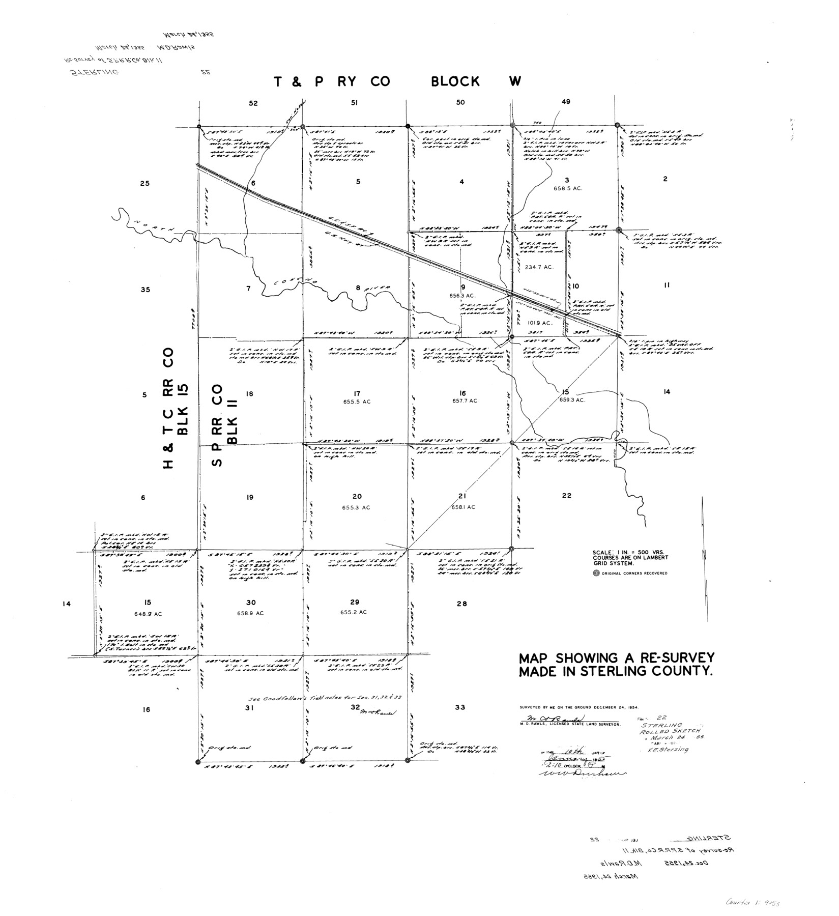
Sterling County Rolled Sketch 22
Map showing a re-survey made in Sterling County
-
Map/Doc
9953
-
Collection
General Map Collection
-
Object Dates
1954/12/24 (Survey Date)
1955/3/24 (File Date)
-
People and Organizations
M.D. Rawls (Surveyor/Engineer)
-
Counties
Sterling
-
Subjects
Surveying Rolled Sketch
-
Height x Width
33.6 x 30.8 inches
85.3 x 78.2 cm
-
Medium
mylar, print
-
Scale
1" = 500 varas
Part of: General Map Collection
Gaines County Rolled Sketch 14B

Print $40.00
- Digital $50.00
Gaines County Rolled Sketch 14B
1940
Size 142.9 x 24.0 inches
Map/Doc 9032

Map of Titus County

Print $20.00
- Digital $50.00
Map of Titus County
1879
Size 23.3 x 14.7 inches
Map/Doc 4082
Reagan County Rolled Sketch 17A

Print $20.00
- Digital $50.00
Reagan County Rolled Sketch 17A
1948
Size 33.8 x 32.4 inches
Map/Doc 9813
Coleman County Rolled Sketch 8

Print $40.00
- Digital $50.00
Coleman County Rolled Sketch 8
1951
Size 58.8 x 40.8 inches
Map/Doc 8634
Flight Mission No. CUG-3P, Frame 93, Kleberg County

Print $20.00
- Digital $50.00
Flight Mission No. CUG-3P, Frame 93, Kleberg County
1956
Size 18.5 x 22.2 inches
Map/Doc 86263
Kinney County Rolled Sketch 4

Print $20.00
- Digital $50.00
Kinney County Rolled Sketch 4
Size 20.8 x 25.0 inches
Map/Doc 7723
Edwards County Sketch File 32 1/2

Print $6.00
- Digital $50.00
Edwards County Sketch File 32 1/2
Size 11.4 x 17.4 inches
Map/Doc 21767
Jack County Boundary File 2

Print $48.00
- Digital $50.00
Jack County Boundary File 2
Size 14.3 x 8.8 inches
Map/Doc 55384
Brewster County Rolled Sketch 57

Print $20.00
- Digital $50.00
Brewster County Rolled Sketch 57
1937
Size 43.1 x 37.8 inches
Map/Doc 8482
Lampasas County Working Sketch 21

Print $20.00
- Digital $50.00
Lampasas County Working Sketch 21
1988
Size 15.2 x 26.7 inches
Map/Doc 70299
Live Oak County Sketch File 11a

Print $4.00
- Digital $50.00
Live Oak County Sketch File 11a
1876
Size 12.7 x 8.3 inches
Map/Doc 30265
You may also like
Midland County

Print $20.00
- Digital $50.00
Midland County
1930
Size 44.9 x 38.5 inches
Map/Doc 73239

Cherokee County Working Sketch 11

Print $20.00
- Digital $50.00
Cherokee County Working Sketch 11
1957
Size 24.3 x 20.2 inches
Map/Doc 67966
Map of the Fort Worth & Denver City Railway

Print $40.00
- Digital $50.00
Map of the Fort Worth & Denver City Railway
1887
Size 21.7 x 72.8 inches
Map/Doc 64479
Brazoria County Working Sketch Graphic Index

Print $20.00
- Digital $50.00
Brazoria County Working Sketch Graphic Index
1947
Size 41.0 x 38.1 inches
Map/Doc 76471
Foard County Sketch File 29

Print $20.00
- Digital $50.00
Foard County Sketch File 29
Size 18.9 x 29.4 inches
Map/Doc 11494
Stonewall County Working Sketch 15

Print $20.00
- Digital $50.00
Stonewall County Working Sketch 15
1954
Size 32.3 x 30.8 inches
Map/Doc 62322
Flight Mission No. CRC-2R, Frame 200, Chambers County

Print $20.00
- Digital $50.00
Flight Mission No. CRC-2R, Frame 200, Chambers County
1956
Size 18.8 x 22.4 inches
Map/Doc 84778
Reeves County Working Sketch 5

Print $20.00
- Digital $50.00
Reeves County Working Sketch 5
1938
Size 38.0 x 32.4 inches
Map/Doc 63448
Shelby County Sketch File 32

Print $20.00
- Digital $50.00
Shelby County Sketch File 32
1949
Size 23.4 x 17.7 inches
Map/Doc 12321
Brazoria County Working Sketch 12

Print $20.00
- Digital $50.00
Brazoria County Working Sketch 12
1936
Size 24.6 x 36.6 inches
Map/Doc 67497
Hood County Working Sketch 10

Print $20.00
- Digital $50.00
Hood County Working Sketch 10
1974
Size 26.7 x 35.6 inches
Map/Doc 66204