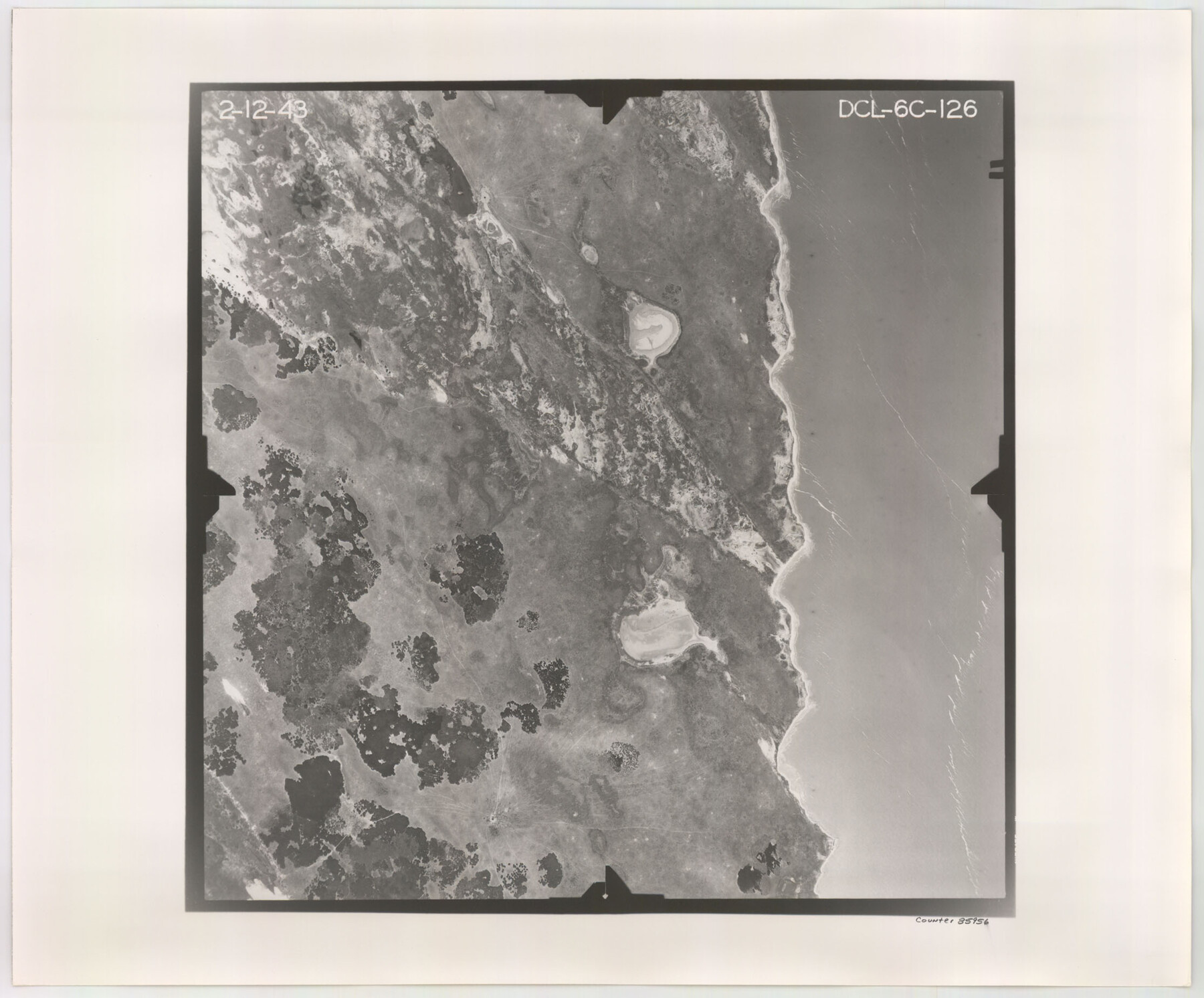
Flight Mission No. DCL-6C, Frame 126, Kenedy County
DCL-6C-126
-
Map/Doc
85956
-
Collection
General Map Collection
-
Object Dates
1943/2/12 (Creation Date)
-
People and Organizations
U. S. Department of Agriculture (Publisher)
-
Counties
Kenedy
-
Subjects
Aerial Photograph
-
Height x Width
18.5 x 22.3 inches
47.0 x 56.6 cm
-
Comments
Flown by Aerial Surveys of Pittsburgh, Inc. of Pittsburgh, Pennsylvania.
Part of: General Map Collection
[Galveston, Harrisburg & San Antonio Railway]
![64404, [Galveston, Harrisburg & San Antonio Railway], General Map Collection](https://historictexasmaps.com/wmedia_w700/maps/64404.tif.jpg)
Print $20.00
- Digital $50.00
[Galveston, Harrisburg & San Antonio Railway]
1892
Size 13.8 x 34.0 inches
Map/Doc 64404
Dickens County Boundary File 2

Print $52.00
- Digital $50.00
Dickens County Boundary File 2
Size 8.9 x 4.2 inches
Map/Doc 52533
Culberson County Sketch File 7

Print $8.00
- Digital $50.00
Culberson County Sketch File 7
1888
Size 14.5 x 8.8 inches
Map/Doc 20138
Padre Island National Seashore, Texas - Dependent Resurvey

Print $4.00
- Digital $50.00
Padre Island National Seashore, Texas - Dependent Resurvey
2001
Size 18.3 x 24.2 inches
Map/Doc 60546
Val Verde County Working Sketch 99

Print $20.00
- Digital $50.00
Val Verde County Working Sketch 99
1981
Size 17.2 x 22.6 inches
Map/Doc 72234
Orange County Rolled Sketch 19

Print $20.00
- Digital $50.00
Orange County Rolled Sketch 19
1945
Size 16.2 x 24.7 inches
Map/Doc 7183
Hunt County Sketch File 29

Print $4.00
- Digital $50.00
Hunt County Sketch File 29
Size 7.4 x 7.8 inches
Map/Doc 27130
Motley County Sketch File 11 (N)

Print $14.00
- Digital $50.00
Motley County Sketch File 11 (N)
1900
Size 11.1 x 8.6 inches
Map/Doc 32036
Medina County Sketch File 6

Print $22.00
- Digital $50.00
Medina County Sketch File 6
1874
Size 8.4 x 12.0 inches
Map/Doc 31454
Orange County Working Sketch 51

Print $20.00
- Digital $50.00
Orange County Working Sketch 51
1992
Size 29.6 x 22.0 inches
Map/Doc 71383
Calhoun County Rolled Sketch 30

Print $20.00
- Digital $50.00
Calhoun County Rolled Sketch 30
1974
Size 18.5 x 27.6 inches
Map/Doc 5489
Harris County Sketch File 59

Print $32.00
- Digital $50.00
Harris County Sketch File 59
1921
Size 14.3 x 9.0 inches
Map/Doc 25480
You may also like
[Working Sketch Survey 46]
![90955, [Working Sketch Survey 46], Twichell Survey Records](https://historictexasmaps.com/wmedia_w700/maps/90955-1.tif.jpg)
Print $20.00
- Digital $50.00
[Working Sketch Survey 46]
Size 19.0 x 11.8 inches
Map/Doc 90955
DeWitt County

Print $40.00
- Digital $50.00
DeWitt County
1987
Size 41.4 x 49.9 inches
Map/Doc 77263
Hutchinson County Rolled Sketch 40

Print $20.00
- Digital $50.00
Hutchinson County Rolled Sketch 40
1981
Size 25.7 x 37.3 inches
Map/Doc 6304
Carte du Mexique et des Pays Limitrophes Situés au Nord et à l'Est

Print $20.00
- Digital $50.00
Carte du Mexique et des Pays Limitrophes Situés au Nord et à l'Est
1811
Size 17.5 x 29.0 inches
Map/Doc 93421
Erath County Working Sketch 22

Print $20.00
- Digital $50.00
Erath County Working Sketch 22
1965
Size 29.8 x 36.8 inches
Map/Doc 69103
North East Corner of Lamar County

Print $3.00
- Digital $50.00
North East Corner of Lamar County
Size 10.7 x 15.4 inches
Map/Doc 291
Port Facilities at Texas City, Tex.

Print $20.00
- Digital $50.00
Port Facilities at Texas City, Tex.
Size 13.9 x 15.9 inches
Map/Doc 97161
Flight Mission No. CGI-4N, Frame 178, Cameron County

Print $20.00
- Digital $50.00
Flight Mission No. CGI-4N, Frame 178, Cameron County
1955
Size 18.6 x 22.3 inches
Map/Doc 84681
North Line of Lynn County and South Line of Lubbock County

Print $20.00
- Digital $50.00
North Line of Lynn County and South Line of Lubbock County
1892
Size 8.0 x 34.2 inches
Map/Doc 91393
Polk County Working Sketch 8

Print $20.00
- Digital $50.00
Polk County Working Sketch 8
1934
Size 24.2 x 30.5 inches
Map/Doc 71623
Nacogdoches County Sketch File 5

Print $4.00
- Digital $50.00
Nacogdoches County Sketch File 5
1859
Size 12.6 x 8.1 inches
Map/Doc 32243
Edwards County Working Sketch 3

Print $20.00
- Digital $50.00
Edwards County Working Sketch 3
Size 22.6 x 18.3 inches
Map/Doc 68879