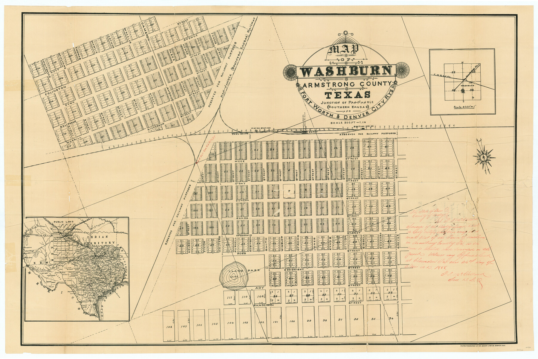
Map of Washburn, Armstrong County, Texas junction of Pan-Handle (Southern Kansas) and Fort Worth & Denver City R'ys
- 
                          Map/Doc
97426
 - 
                            Collection
General Map Collection
 - 
                            Object Dates
11/26/1888 (Creation Date)
 - 
                            People and Organizations
Denver Lithographic Company (Lithographer)
T.S. McClelland (Surveyor/Engineer)
 - 
                            Counties
Armstrong
 - 
                            Subjects
City Railroads
 - 
                            Scale
1" = 300 feet
 - 
                            Comments
Map was separated from School File 23124.
 
Part of: General Map Collection
            Throckmorton County


                                            Print $20.00                    
                                             -                         Digital $50.00                                    
                Throckmorton County
1943
Size 46.3 x 37.8 inches
                                Map/Doc 73302
            
            Jefferson County Working Sketch 16


                                            Print $20.00                    
                                             -                         Digital $50.00                                    
                Jefferson County Working Sketch 16
1954
Size 31.0 x 18.8 inches
                                Map/Doc 66559
            
            Map of the Rio Grande & Eagle Pass Ry. from Sections 14-20 Inclusive, Webb County


                                            Print $40.00                    
                                             -                         Digital $50.00                                    
                Map of the Rio Grande & Eagle Pass Ry. from Sections 14-20 Inclusive, Webb County
1909
Size 25.3 x 55.6 inches
                                Map/Doc 64657
            
            Washington County


                                            Print $20.00                    
                                             -                         Digital $50.00                                    
                Washington County
1976
Size 31.7 x 46.5 inches
                                Map/Doc 73317
            
            Sutton County


                                            Print $40.00                    
                                             -                         Digital $50.00                                    
                Sutton County
1941
Size 43.9 x 56.1 inches
                                Map/Doc 73296
            
            Franklin County Sketch File 5


                                            Print $2.00                    
                                             -                         Digital $50.00                                    
                Franklin County Sketch File 5
Size 8.2 x 10.7 inches
                                Map/Doc 23017
            
            Falls County Working Sketch 3


                                            Print $20.00                    
                                             -                         Digital $50.00                                    
                Falls County Working Sketch 3
1922
Size 34.0 x 27.8 inches
                                Map/Doc 69178
            
            Dallas County Rolled Sketch 3


                                            Print $40.00                    
                                             -                         Digital $50.00                                    
                Dallas County Rolled Sketch 3
1953
Size 30.7 x 78.5 inches
                                Map/Doc 8767
            
            Terrell County Working Sketch 82


                                            Print $20.00                    
                                             -                         Digital $50.00                                    
                Terrell County Working Sketch 82
1991
Size 31.7 x 24.8 inches
                                Map/Doc 69603
            
            Texas, Corpus Christi Bay, Red Fish Bay to Nueces Bay


                                            Print $40.00                    
                                             -                         Digital $50.00                                    
                Texas, Corpus Christi Bay, Red Fish Bay to Nueces Bay
1934
Size 31.8 x 48.3 inches
                                Map/Doc 73459
            
            Sutton County Rolled Sketch 65


                                            Print $20.00                    
                                             -                         Digital $50.00                                    
                Sutton County Rolled Sketch 65
Size 40.8 x 30.5 inches
                                Map/Doc 7900
            You may also like
            United States - Gulf Coast - From Latitude 26° 33' to the Rio Grande Texas


                                            Print $20.00                    
                                             -                         Digital $50.00                                    
                United States - Gulf Coast - From Latitude 26° 33' to the Rio Grande Texas
1918
Size 27.1 x 18.4 inches
                                Map/Doc 72852
            
            Midland County Sketch File 18


                                            Print $4.00                    
                                             -                         Digital $50.00                                    
                Midland County Sketch File 18
Size 14.7 x 8.1 inches
                                Map/Doc 31585
            
            Map of the United States and Mexico showing the Trans-Union and Tehuantepec route between Europe and Asia


                                            Print $20.00                    
                                             -                         Digital $50.00                                    
                Map of the United States and Mexico showing the Trans-Union and Tehuantepec route between Europe and Asia
1851
Size 20.3 x 23.7 inches
                                Map/Doc 94851
            
            Intracoastal Waterway in Texas - Corpus Christi to Point Isabel including Arroyo Colorado to Mo. Pac. R.R. Bridge Near Harlingen


                                            Print $20.00                    
                                             -                         Digital $50.00                                    
                Intracoastal Waterway in Texas - Corpus Christi to Point Isabel including Arroyo Colorado to Mo. Pac. R.R. Bridge Near Harlingen
1933
Size 28.0 x 40.7 inches
                                Map/Doc 61848
            
            Limestone County Working Sketch 20


                                            Print $20.00                    
                                             -                         Digital $50.00                                    
                Limestone County Working Sketch 20
1976
Size 41.5 x 42.3 inches
                                Map/Doc 70570
            
            Plat of Common Line of Baylor and Throckmorton Counties as Run by A.D. Kerr and F.B. Stribling


                                            Print $40.00                    
                                             -                         Digital $50.00                                    
                Plat of Common Line of Baylor and Throckmorton Counties as Run by A.D. Kerr and F.B. Stribling
Size 63.0 x 9.0 inches
                                Map/Doc 89640
            
            Young County Working Sketch 9


                                            Print $20.00                    
                                             -                         Digital $50.00                                    
                Young County Working Sketch 9
1921
Size 25.9 x 36.6 inches
                                Map/Doc 62032
            
            Calhoun County Sketch File 2


                                            Print $40.00                    
                                             -                         Digital $50.00                                    
                Calhoun County Sketch File 2
1856
Size 20.2 x 15.8 inches
                                Map/Doc 11032
            
            [I. & G. N. RR. Co. Block I]


                                            Print $20.00                    
                                             -                         Digital $50.00                                    
                [I. & G. N. RR. Co. Block I]
Size 43.0 x 31.7 inches
                                Map/Doc 89828
            
            Brewster County Sketch File NS-9


                                            Print $40.00                    
                                             -                         Digital $50.00                                    
                Brewster County Sketch File NS-9
1944
Size 14.2 x 8.9 inches
                                Map/Doc 16135
            
            Location of the Southern Kansas Railway of Texas, Roberts County, Texas


                                            Print $40.00                    
                                             -                         Digital $50.00                                    
                Location of the Southern Kansas Railway of Texas, Roberts County, Texas
1887
Size 20.0 x 75.1 inches
                                Map/Doc 64037
            
            Hopkins County Sketch File 10


                                            Print $4.00                    
                                             -                         Digital $50.00                                    
                Hopkins County Sketch File 10
1856
Size 9.1 x 8.2 inches
                                Map/Doc 26700