Hewlett-Packard 32E scientific calculator
Manufacturer: Hewlett-Packard Serial Number: 2037S37087 State Inventory Tag: 305-6410 Case: Leatherette case Manufacture Location: Singapore
-
Map/Doc
97318
-
Collection
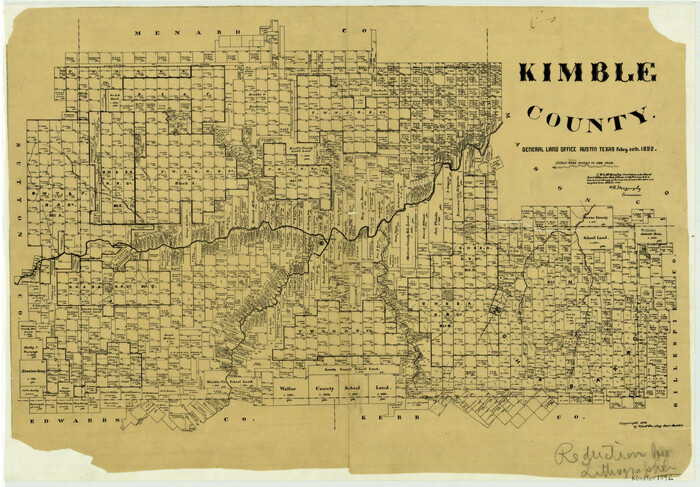
General Map Collection
-
Object Dates
(Creation Date)
Part of: General Map Collection
Montgomery County Working Sketch 73

Print $20.00
- Digital $50.00
Montgomery County Working Sketch 73
Size 19.5 x 42.9 inches
Map/Doc 71180
Township No. 2 South Range No. 21 West of the Indian Meridian

Print $20.00
- Digital $50.00
Township No. 2 South Range No. 21 West of the Indian Meridian
1875
Size 19.3 x 24.4 inches
Map/Doc 75177
Flight Mission No. DCL-6C, Frame 113, Kenedy County

Print $20.00
- Digital $50.00
Flight Mission No. DCL-6C, Frame 113, Kenedy County
1943
Size 15.5 x 15.3 inches
Map/Doc 85943
Milam County Working Sketch 7

Print $40.00
- Digital $50.00
Milam County Working Sketch 7
Size 42.7 x 48.0 inches
Map/Doc 71022
Tarrant County Sketch File 9

Print $4.00
- Digital $50.00
Tarrant County Sketch File 9
1858
Size 6.5 x 8.4 inches
Map/Doc 37689
El Paso County Rolled Sketch 52

Print $20.00
- Digital $50.00
El Paso County Rolled Sketch 52
1929
Size 18.5 x 24.5 inches
Map/Doc 5847
Flight Mission No. BRA-7M, Frame 138, Jefferson County

Print $20.00
- Digital $50.00
Flight Mission No. BRA-7M, Frame 138, Jefferson County
1953
Size 18.6 x 22.4 inches
Map/Doc 85532
Bandera County Sketch File 23

Print $40.00
- Digital $50.00
Bandera County Sketch File 23
1881
Size 16.1 x 13.7 inches
Map/Doc 10895
Sterling County Rolled Sketch 30

Print $20.00
- Digital $50.00
Sterling County Rolled Sketch 30
Size 20.4 x 27.8 inches
Map/Doc 7855
Upton County Working Sketch 1

Print $20.00
- Digital $50.00
Upton County Working Sketch 1
Size 11.6 x 20.0 inches
Map/Doc 69497
Van Zandt County Working Sketch Graphic Index

Print $20.00
- Digital $50.00
Van Zandt County Working Sketch Graphic Index
1972
Size 46.2 x 40.7 inches
Map/Doc 76727
You may also like
Brooks County Boundary File 1c

Print $40.00
- Digital $50.00
Brooks County Boundary File 1c
Size 63.4 x 6.7 inches
Map/Doc 50838
Jefferson County Rolled Sketch 34

Print $20.00
- Digital $50.00
Jefferson County Rolled Sketch 34
1957
Size 43.9 x 34.6 inches
Map/Doc 9296
Flight Mission No. DIX-10P, Frame 177, Aransas County

Print $20.00
- Digital $50.00
Flight Mission No. DIX-10P, Frame 177, Aransas County
1956
Size 18.6 x 22.3 inches
Map/Doc 83967

Titus County Sketch File 14

Print $4.00
- Digital $50.00
Titus County Sketch File 14
Size 9.7 x 8.3 inches
Map/Doc 38157
[Part of Wichita County in the vicinity of Elizabeth Stanley survey 812 and W. M. Rivers survey 810]
![91971, [Part of Wichita County in the vicinity of Elizabeth Stanley survey 812 and W. M. Rivers survey 810], Twichell Survey Records](https://historictexasmaps.com/wmedia_w700/maps/91971-1.tif.jpg)
Print $3.00
- Digital $50.00
[Part of Wichita County in the vicinity of Elizabeth Stanley survey 812 and W. M. Rivers survey 810]
1920
Size 11.5 x 11.7 inches
Map/Doc 91971
Coke County Rolled Sketch 2

Print $20.00
- Digital $50.00
Coke County Rolled Sketch 2
1947
Size 15.5 x 17.4 inches
Map/Doc 5504
Flight Mission No. DCL-7C, Frame 124, Kenedy County

Print $20.00
- Digital $50.00
Flight Mission No. DCL-7C, Frame 124, Kenedy County
1943
Size 18.6 x 22.2 inches
Map/Doc 86089
San Angelo/Big Spring, Texas Street Map "A Traveler's Best Friend"

San Angelo/Big Spring, Texas Street Map "A Traveler's Best Friend"
Size 37.5 x 24.9 inches
Map/Doc 94399
[Capitol Leagues 217- 235, 238, and 239]
![90706, [Capitol Leagues 217- 235, 238, and 239], Twichell Survey Records](https://historictexasmaps.com/wmedia_w700/maps/90706-1.tif.jpg)
Print $20.00
- Digital $50.00
[Capitol Leagues 217- 235, 238, and 239]
Size 26.3 x 26.9 inches
Map/Doc 90706
Hemphill County Sketch File 3

Print $8.00
- Digital $50.00
Hemphill County Sketch File 3
Size 11.4 x 6.5 inches
Map/Doc 26285
[Aerial photograph from Carancahua Bend of Caney Creek to Cedar Lake]
![78639, [Aerial photograph from Carancahua Bend of Caney Creek to Cedar Lake], General Map Collection](https://historictexasmaps.com/wmedia_w700/maps/78639.tif.jpg)
Print $20.00
- Digital $50.00
[Aerial photograph from Carancahua Bend of Caney Creek to Cedar Lake]
1991
Size 24.4 x 34.0 inches
Map/Doc 78639