Pecos County Rolled Sketch 134
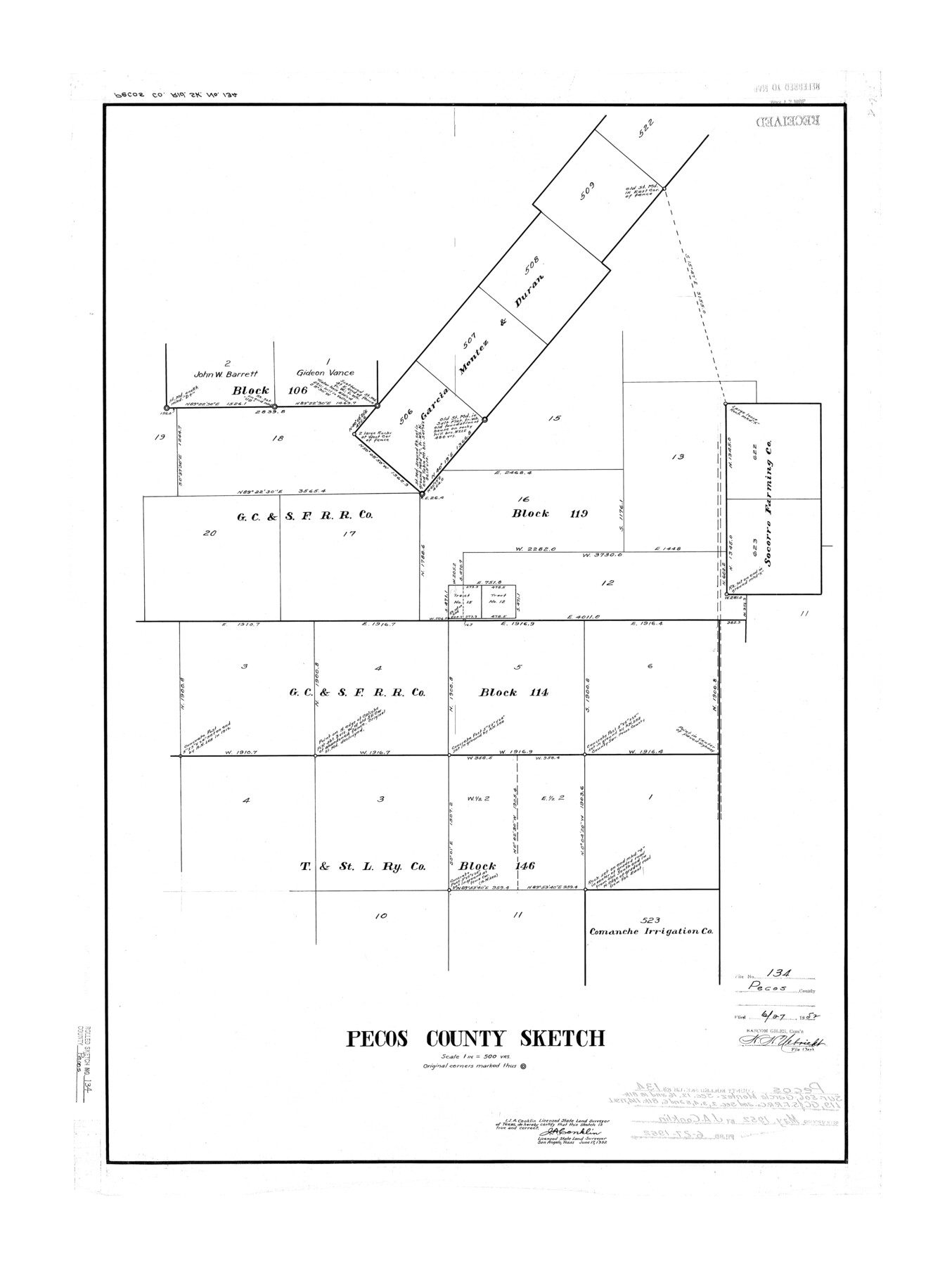
Pecos County sketch [showing parts of Blocks 114 & 119, G. C. & S. F. R.R. Co. and Block 146, T. & St. L. Ry. Co.]
-
Map/Doc
7270
-
Collection
General Map Collection
-
Object Dates
1952/6/17 (Creation Date)
1952/6/27 (File Date)
-
People and Organizations
J.A. Conklin (Surveyor/Engineer)
-
Counties
Pecos
-
Subjects
Surveying Rolled Sketch
-
Height x Width
35.9 x 27.0 inches
91.2 x 68.6 cm
-
Scale
1" = 500 varas
Part of: General Map Collection
Calhoun County Sketch File 2

Print $40.00
- Digital $50.00
Calhoun County Sketch File 2
1856
Size 20.2 x 15.8 inches
Map/Doc 11032
Bandera County Working Sketch 44

Print $20.00
- Digital $50.00
Bandera County Working Sketch 44
1980
Size 14.0 x 20.4 inches
Map/Doc 67640
Pecos County Working Sketch 56

Print $40.00
- Digital $50.00
Pecos County Working Sketch 56
1949
Size 29.9 x 57.4 inches
Map/Doc 71528
Reeves County Rolled Sketch 14A

Print $20.00
- Digital $50.00
Reeves County Rolled Sketch 14A
1948
Size 26.0 x 18.9 inches
Map/Doc 7483
Brazoria County NRC Article 33.136 Location Key Sheet

Print $20.00
- Digital $50.00
Brazoria County NRC Article 33.136 Location Key Sheet
1963
Size 27.0 x 22.0 inches
Map/Doc 77009
Brewster County Rolled Sketch 11A

Print $20.00
- Digital $50.00
Brewster County Rolled Sketch 11A
1881
Size 24.9 x 23.0 inches
Map/Doc 5192
Ward County Sketch File 6

Print $20.00
- Digital $50.00
Ward County Sketch File 6
Size 21.6 x 45.5 inches
Map/Doc 10427
Flight Mission No. CRK-7P, Frame 134, Refugio County

Print $20.00
- Digital $50.00
Flight Mission No. CRK-7P, Frame 134, Refugio County
1956
Size 18.4 x 22.1 inches
Map/Doc 86957
[Texas & Pacific Railway through Callahan County]
![64235, [Texas & Pacific Railway through Callahan County], General Map Collection](https://historictexasmaps.com/wmedia_w700/maps/64235.tif.jpg)
Print $20.00
- Digital $50.00
[Texas & Pacific Railway through Callahan County]
1918
Size 23.2 x 8.3 inches
Map/Doc 64235
Texas-Louisiana Gulf Coastal Region showing Oil & Gas Fields & Prospects, Pipe Lines, Refineries & Principal Highways

Print $20.00
- Digital $50.00
Texas-Louisiana Gulf Coastal Region showing Oil & Gas Fields & Prospects, Pipe Lines, Refineries & Principal Highways
1933
Size 22.4 x 44.2 inches
Map/Doc 96874
Aransas County Sketch File 15a

Print $14.00
- Digital $50.00
Aransas County Sketch File 15a
Size 11.0 x 8.4 inches
Map/Doc 13136
Presidio County Rolled Sketch WR1

Print $20.00
- Digital $50.00
Presidio County Rolled Sketch WR1
1927
Size 20.4 x 23.0 inches
Map/Doc 7421
You may also like
Hemphill County Working Sketch 24

Print $40.00
- Digital $50.00
Hemphill County Working Sketch 24
1974
Size 48.6 x 37.4 inches
Map/Doc 66119
America with those known parts in that unknowne worlde both people and manner of buildings

Print $20.00
- Digital $50.00
America with those known parts in that unknowne worlde both people and manner of buildings
1626
Size 17.2 x 22.3 inches
Map/Doc 93830
Flight Mission No. BRA-8M, Frame 65, Jefferson County

Print $20.00
- Digital $50.00
Flight Mission No. BRA-8M, Frame 65, Jefferson County
1953
Size 18.6 x 22.4 inches
Map/Doc 85585
Real County Working Sketch 42

Print $20.00
- Digital $50.00
Real County Working Sketch 42
1953
Size 40.3 x 34.5 inches
Map/Doc 71934
Flight Mission No. CRC-3R, Frame 165, Chambers County

Print $20.00
- Digital $50.00
Flight Mission No. CRC-3R, Frame 165, Chambers County
1956
Size 18.8 x 22.5 inches
Map/Doc 84847

Stephens County Working Sketch 6

Print $20.00
- Digital $50.00
Stephens County Working Sketch 6
1919
Size 13.1 x 22.0 inches
Map/Doc 63949
King County Rolled Sketch 12

Print $20.00
- Digital $50.00
King County Rolled Sketch 12
1955
Size 40.9 x 45.7 inches
Map/Doc 9352
[Sabine County School Land and Blocks A4, W, and DT]
![92697, [Sabine County School Land and Blocks A4, W, and DT], Twichell Survey Records](https://historictexasmaps.com/wmedia_w700/maps/92697-1.tif.jpg)
Print $20.00
- Digital $50.00
[Sabine County School Land and Blocks A4, W, and DT]
Size 18.9 x 15.6 inches
Map/Doc 92697
Flight Mission No. CRE-1R, Frame 136, Jackson County

Print $20.00
- Digital $50.00
Flight Mission No. CRE-1R, Frame 136, Jackson County
1956
Size 16.0 x 15.9 inches
Map/Doc 85344
Ownership Map of Val Verde County

Print $20.00
- Digital $50.00
Ownership Map of Val Verde County
1927
Size 32.7 x 36.9 inches
Map/Doc 92847
La Salle County Sketch File 42 and 42a

Print $28.00
- Digital $50.00
La Salle County Sketch File 42 and 42a
1926
Size 11.1 x 8.9 inches
Map/Doc 29597