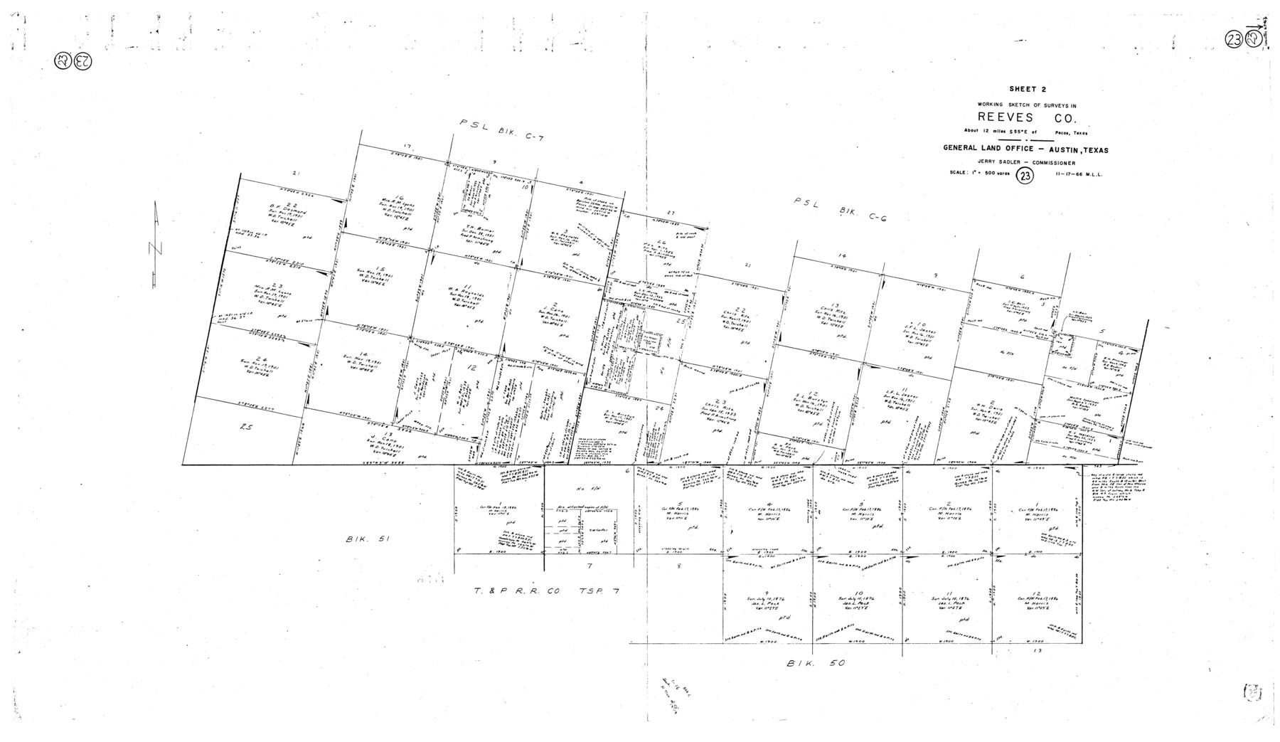
Reeves County Working Sketch 23
-
Map/Doc
63466
-
Collection
General Map Collection
-
Object Dates
11/17/1966 (Creation Date)
-
People and Organizations
M. L. Liles (Draftsman)
-
Counties
Reeves
-
Subjects
Surveying Working Sketch
-
Height x Width
31.6 x 54.5 inches
80.3 x 138.4 cm
-
Scale
1" = 500 varas
Part of: General Map Collection
Newton County Working Sketch 25

Print $20.00
- Digital $50.00
Newton County Working Sketch 25
1953
Size 25.4 x 23.8 inches
Map/Doc 71271
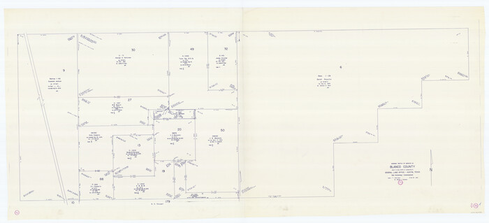
Bosque County Working Sketch 27

Print $20.00
- Digital $50.00
Bosque County Working Sketch 27
2006
Size 29.8 x 38.0 inches
Map/Doc 85241
Presidio County Sketch File 39

Print $6.00
- Digital $50.00
Presidio County Sketch File 39
1912
Size 13.3 x 8.9 inches
Map/Doc 34512
Bandera County

Print $40.00
- Digital $50.00
Bandera County
1904
Size 30.7 x 61.0 inches
Map/Doc 3274
Moore County Rolled Sketch 16

Print $20.00
- Digital $50.00
Moore County Rolled Sketch 16
1981
Size 21.8 x 27.8 inches
Map/Doc 6833
San Jacinto County Working Sketch 6

Print $20.00
- Digital $50.00
San Jacinto County Working Sketch 6
1934
Size 37.1 x 42.5 inches
Map/Doc 63719
Nueces County Sketch File 17

Print $20.00
- Digital $50.00
Nueces County Sketch File 17
1854
Size 24.8 x 26.6 inches
Map/Doc 42180
Chambers County Sketch File 56

Print $7.00
- Digital $50.00
Chambers County Sketch File 56
Size 14.8 x 8.7 inches
Map/Doc 18099
Blanco County Working Sketch 34
Print $40.00
- Digital $50.00
Blanco County Working Sketch 34
1978
Size 36.3 x 79.6 inches
Map/Doc 67394
[Surveys in Milam's Colony along the Colorado River, Onion Creek, Cedar Creek, and north of the San Antonio Road]
![88, [Surveys in Milam's Colony along the Colorado River, Onion Creek, Cedar Creek, and north of the San Antonio Road], General Map Collection](https://historictexasmaps.com/wmedia_w700/maps/88-1.tif.jpg)
Print $20.00
- Digital $50.00
[Surveys in Milam's Colony along the Colorado River, Onion Creek, Cedar Creek, and north of the San Antonio Road]
Size 13.4 x 26.8 inches
Map/Doc 88
History of the Geography of Texas

Print $40.00
- Digital $50.00
History of the Geography of Texas
1897
Size 70.7 x 52.9 inches
Map/Doc 3095
Bell County Sketch File 26

Print $14.00
- Digital $50.00
Bell County Sketch File 26
1886
Size 14.2 x 8.8 inches
Map/Doc 14426
You may also like
Montgomery County Sketch File 36a

Print $8.00
- Digital $50.00
Montgomery County Sketch File 36a
1953
Size 14.4 x 8.8 inches
Map/Doc 31912
Washington County Working Sketch 3

Print $20.00
- Digital $50.00
Washington County Working Sketch 3
1992
Size 31.5 x 42.7 inches
Map/Doc 72364
Index sheet to accompany map of survey for connecting the inland waters along margin of the Gulf of Mexico from Donaldsonville in Louisiana to the Rio Grande River in Texas

Print $20.00
- Digital $50.00
Index sheet to accompany map of survey for connecting the inland waters along margin of the Gulf of Mexico from Donaldsonville in Louisiana to the Rio Grande River in Texas
1874
Size 18.1 x 26.9 inches
Map/Doc 72694
Map of Montague County

Print $20.00
- Digital $50.00
Map of Montague County
1858
Size 28.6 x 20.5 inches
Map/Doc 3886
Loving County Working Sketch 4

Print $20.00
- Digital $50.00
Loving County Working Sketch 4
1941
Size 20.1 x 40.2 inches
Map/Doc 70636
[Coleman County Sections 359, 360, and 361]
![92553, [Coleman County Sections 359, 360, and 361], Twichell Survey Records](https://historictexasmaps.com/wmedia_w700/maps/92553-1.tif.jpg)
Print $20.00
- Digital $50.00
[Coleman County Sections 359, 360, and 361]
Size 17.6 x 22.5 inches
Map/Doc 92553
[Sketch of Col. Cooke's Military Road expedition from Red River to Austin]
![82272, [Sketch of Col. Cooke's Military Road expedition from Red River to Austin], General Map Collection](https://historictexasmaps.com/wmedia_w700/maps/82272-1.tif.jpg)
Print $40.00
- Digital $50.00
[Sketch of Col. Cooke's Military Road expedition from Red River to Austin]
Size 61.0 x 24.1 inches
Map/Doc 82272
San Patricio County Rolled Sketch 43

Print $1233.00
- Digital $50.00
San Patricio County Rolled Sketch 43
Size 8.8 x 14.2 inches
Map/Doc 41814
Flight Mission No. DQN-6K, Frame 93, Calhoun County

Print $20.00
- Digital $50.00
Flight Mission No. DQN-6K, Frame 93, Calhoun County
1953
Size 18.4 x 22.1 inches
Map/Doc 84453
Flight Mission No. CUG-2P, Frame 80, Kleberg County

Print $20.00
- Digital $50.00
Flight Mission No. CUG-2P, Frame 80, Kleberg County
1956
Size 18.5 x 22.1 inches
Map/Doc 86212
Dawson County Rolled Sketch 3

Print $20.00
- Digital $50.00
Dawson County Rolled Sketch 3
1903
Size 20.9 x 36.8 inches
Map/Doc 8770
Map of the Country Upon the Brazos and Big Wichita Rivers Embracing the Lands appropriated by the State of Texas for the Use of the Indians

Print $20.00
Map of the Country Upon the Brazos and Big Wichita Rivers Embracing the Lands appropriated by the State of Texas for the Use of the Indians
1854
Size 28.8 x 32.3 inches
Map/Doc 76284