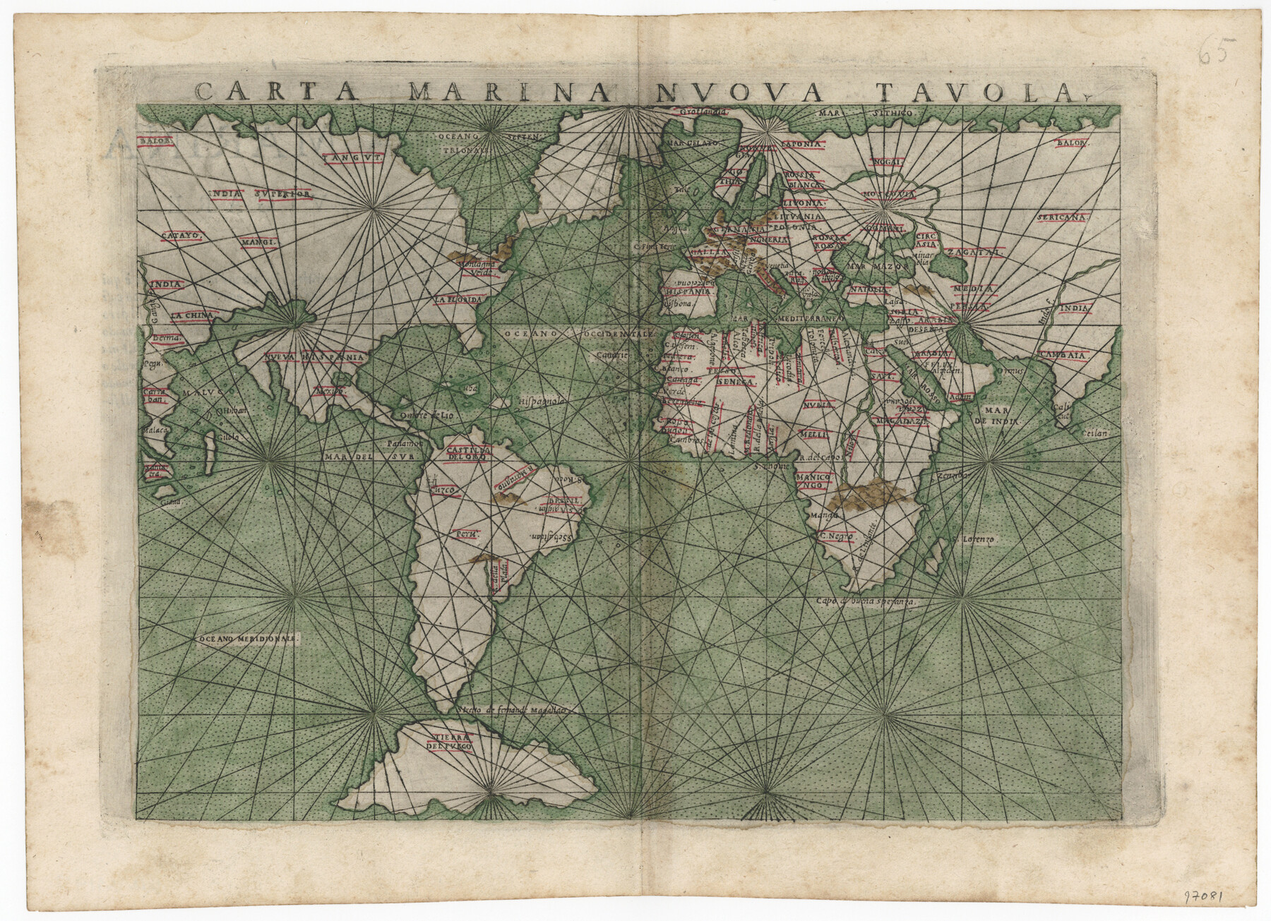
Carta Marina Nvova Tavola
-
Map/Doc
97081
-
Collection
General Map Collection
-
Object Dates
[1574 ca.] (Creation Date)
-
People and Organizations
[Girolamo Ruscelli] (Cartographer)
-
Subjects
World
-
Height x Width
9.0 x 12.4 inches
22.9 x 31.5 cm
-
Medium
paper, etching/engraving/lithograph
-
Comments
To view text on verso, click the "Download PDF" link above.
Part of: General Map Collection
Live Oak County Boundary File 60a

Print $18.00
- Digital $50.00
Live Oak County Boundary File 60a
Size 12.7 x 8.4 inches
Map/Doc 56407
Hockley County Boundary File 2

Print $40.00
- Digital $50.00
Hockley County Boundary File 2
Size 23.8 x 6.8 inches
Map/Doc 54802
Flight Mission No. BRA-16M, Frame 151, Jefferson County

Print $20.00
- Digital $50.00
Flight Mission No. BRA-16M, Frame 151, Jefferson County
1953
Size 18.7 x 22.3 inches
Map/Doc 85757
Montgomery County Working Sketch 15

Print $40.00
- Digital $50.00
Montgomery County Working Sketch 15
1934
Size 51.8 x 41.6 inches
Map/Doc 71122
Presidio County Sketch File 79

Print $20.00
- Digital $50.00
Presidio County Sketch File 79
1949
Size 17.0 x 30.8 inches
Map/Doc 11722
Hardin County Working Sketch 4

Print $3.00
- Digital $50.00
Hardin County Working Sketch 4
1906
Size 11.0 x 16.8 inches
Map/Doc 63402
Map of Newton County

Print $40.00
- Digital $50.00
Map of Newton County
1894
Size 74.9 x 27.7 inches
Map/Doc 16778
Frio County Rolled Sketch 9

Print $20.00
- Digital $50.00
Frio County Rolled Sketch 9
1943
Size 35.7 x 32.5 inches
Map/Doc 5919
Milam County Boundary File 5

Print $18.00
- Digital $50.00
Milam County Boundary File 5
Size 8.9 x 9.7 inches
Map/Doc 57223
Navarro County Boundary File 1a

Print $42.00
- Digital $50.00
Navarro County Boundary File 1a
Size 9.5 x 6.1 inches
Map/Doc 57605
Webb County Sketch File 7-2

Print $20.00
- Digital $50.00
Webb County Sketch File 7-2
1927
Size 31.6 x 23.7 inches
Map/Doc 12618
[Sketch for Mineral Application 26501 - Sabine River, T. A. Oldhausen]
![2837, [Sketch for Mineral Application 26501 - Sabine River, T. A. Oldhausen], General Map Collection](https://historictexasmaps.com/wmedia_w700/maps/2837.tif.jpg)
Print $20.00
- Digital $50.00
[Sketch for Mineral Application 26501 - Sabine River, T. A. Oldhausen]
1931
Size 24.1 x 36.0 inches
Map/Doc 2837
You may also like
Dickens County Sketch File H2

Print $4.00
- Digital $50.00
Dickens County Sketch File H2
Size 12.7 x 8.1 inches
Map/Doc 20873
Terrell County Working Sketch 6

Print $20.00
- Digital $50.00
Terrell County Working Sketch 6
1914
Size 15.7 x 21.9 inches
Map/Doc 62155
Concho County Working Sketch 24

Print $20.00
- Digital $50.00
Concho County Working Sketch 24
1981
Size 35.0 x 44.2 inches
Map/Doc 68206
Reagan County Rolled Sketch 6

Print $20.00
- Digital $50.00
Reagan County Rolled Sketch 6
Size 17.8 x 17.3 inches
Map/Doc 7435
Brewster County Sketch File 45

Print $2.00
- Digital $50.00
Brewster County Sketch File 45
Size 10.7 x 8.2 inches
Map/Doc 16312
Flight Mission No. BRA-8M, Frame 149, Jefferson County

Print $20.00
- Digital $50.00
Flight Mission No. BRA-8M, Frame 149, Jefferson County
1953
Size 18.8 x 22.4 inches
Map/Doc 85641
La Salle County Sketch File 39

Print $6.00
- Digital $50.00
La Salle County Sketch File 39
1912
Size 16.4 x 11.4 inches
Map/Doc 29592
Burleson County

Print $20.00
- Digital $50.00
Burleson County
1920
Size 40.7 x 45.2 inches
Map/Doc 66740
Map of the Fort Worth & Denver City Ry., Dallam County, Texas

Print $40.00
- Digital $50.00
Map of the Fort Worth & Denver City Ry., Dallam County, Texas
1887
Size 21.3 x 111.8 inches
Map/Doc 64352
Meanders of Sulphur Fork of Red River, Red River County, Texas

Print $2.00
- Digital $50.00
Meanders of Sulphur Fork of Red River, Red River County, Texas
1841
Size 6.8 x 9.7 inches
Map/Doc 65777

South Part Pecos County

Print $20.00
- Digital $50.00
South Part Pecos County
1976
Size 36.8 x 44.2 inches
Map/Doc 73262