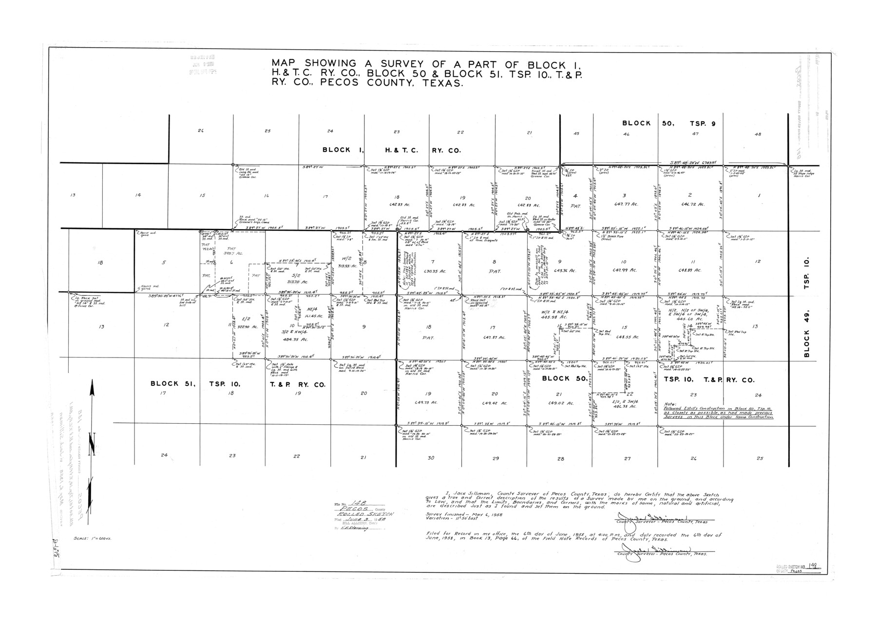
Pecos County Rolled Sketch 148
Map showing a survey of a part of Block 1, H. & T. C. Ry. Co., Block 50 & Block 51, Tsp. 10, T. & P. Ry. Co., Pecos County, Texas
-
Map/Doc
7279
-
Collection
General Map Collection
-
Object Dates
1958/5/6 (Survey Date)
1958/6/9 (File Date)
-
People and Organizations
Jack Silliman (Surveyor/Engineer)
-
Counties
Pecos
-
Subjects
Surveying Rolled Sketch
-
Height x Width
30.3 x 42.6 inches
77.0 x 108.2 cm
-
Scale
1" = 600 varas
Part of: General Map Collection
Val Verde County Sketch File XXX1

Print $20.00
- Digital $50.00
Val Verde County Sketch File XXX1
Size 18.8 x 24.0 inches
Map/Doc 12547
Hutchinson County Rolled Sketch 44-15

Print $20.00
- Digital $50.00
Hutchinson County Rolled Sketch 44-15
2002
Size 24.0 x 36.0 inches
Map/Doc 77551
Runnels County Sketch File C

Print $4.00
Runnels County Sketch File C
Size 14.2 x 8.8 inches
Map/Doc 35457
Clay County Sketch File 10

Print $4.00
- Digital $50.00
Clay County Sketch File 10
1860
Size 8.8 x 7.6 inches
Map/Doc 18406
Presidio County Working Sketch 106

Print $40.00
- Digital $50.00
Presidio County Working Sketch 106
1980
Size 25.4 x 74.7 inches
Map/Doc 71783
Andrews County Rolled Sketch 32

Print $20.00
- Digital $50.00
Andrews County Rolled Sketch 32
1950
Size 26.2 x 16.4 inches
Map/Doc 77176
Map of Zavalla County

Print $20.00
- Digital $50.00
Map of Zavalla County
1862
Size 24.2 x 20.5 inches
Map/Doc 4180
Sherman County

Print $20.00
- Digital $50.00
Sherman County
1932
Size 39.8 x 37.3 inches
Map/Doc 95640
Hays County Sketch File 4

Print $4.00
- Digital $50.00
Hays County Sketch File 4
Size 8.5 x 7.0 inches
Map/Doc 26204
Nueces County Rolled Sketch 118

Print $20.00
- Digital $50.00
Nueces County Rolled Sketch 118
1988
Size 19.5 x 35.4 inches
Map/Doc 7150
Sketch showing progress of topographical work Laguna Madre and vicinity from Rainey Is. to Baffins Bay, Coast of Texas Sect. IX [and accompanying letter]
![72957, Sketch showing progress of topographical work Laguna Madre and vicinity from Rainey Is. to Baffins Bay, Coast of Texas Sect. IX [and accompanying letter], General Map Collection](https://historictexasmaps.com/wmedia_w700/maps/72957.tif.jpg)
Print $20.00
- Digital $50.00
Sketch showing progress of topographical work Laguna Madre and vicinity from Rainey Is. to Baffins Bay, Coast of Texas Sect. IX [and accompanying letter]
1880
Size 39.2 x 18.6 inches
Map/Doc 72957
Anderson County Working Sketch 21

Print $20.00
- Digital $50.00
Anderson County Working Sketch 21
1954
Size 24.9 x 33.9 inches
Map/Doc 67021
You may also like
Jim Wells County Working Sketch 8

Print $20.00
- Digital $50.00
Jim Wells County Working Sketch 8
1947
Size 23.8 x 26.0 inches
Map/Doc 66606
Johnson County Sketch File 14a

Print $6.00
- Digital $50.00
Johnson County Sketch File 14a
1862
Size 8.0 x 11.1 inches
Map/Doc 28452
Terrell County Working Sketch 50

Print $40.00
- Digital $50.00
Terrell County Working Sketch 50
1958
Size 43.0 x 64.3 inches
Map/Doc 62143
Map of Taylor County

Print $20.00
- Digital $50.00
Map of Taylor County
1858
Size 24.0 x 25.3 inches
Map/Doc 4070
Flight Mission No. BQY-4M, Frame 125, Harris County

Print $20.00
- Digital $50.00
Flight Mission No. BQY-4M, Frame 125, Harris County
1953
Size 18.6 x 22.5 inches
Map/Doc 85293
Navarro County Sketch File 20

Print $14.00
- Digital $50.00
Navarro County Sketch File 20
1967
Size 14.3 x 8.8 inches
Map/Doc 32343
Harris County Sketch File 11a

Print $6.00
- Digital $50.00
Harris County Sketch File 11a
Size 11.0 x 10.0 inches
Map/Doc 25351
Map of Val Verde County

Print $20.00
- Digital $50.00
Map of Val Verde County
1898
Size 42.9 x 37.5 inches
Map/Doc 63098
Jefferson County Sketch File 24

Print $6.00
- Digital $50.00
Jefferson County Sketch File 24
Size 10.8 x 6.8 inches
Map/Doc 28181
Map of the City of Dallas, Texas, compiled from the records of Dallas Co., and latest surveys of the City Engineer

Map of the City of Dallas, Texas, compiled from the records of Dallas Co., and latest surveys of the City Engineer
1878
Size 22.9 x 31.1 inches
Map/Doc 76174
Presidio County Sketch File 35A

Print $20.00
- Digital $50.00
Presidio County Sketch File 35A
1906
Size 12.5 x 20.9 inches
Map/Doc 11713
Gulf Oil Corp. Fishgide - Freeport

Gulf Oil Corp. Fishgide - Freeport
1960
Size 12.1 x 22.1 inches
Map/Doc 75979