Mason County Sketch File 24
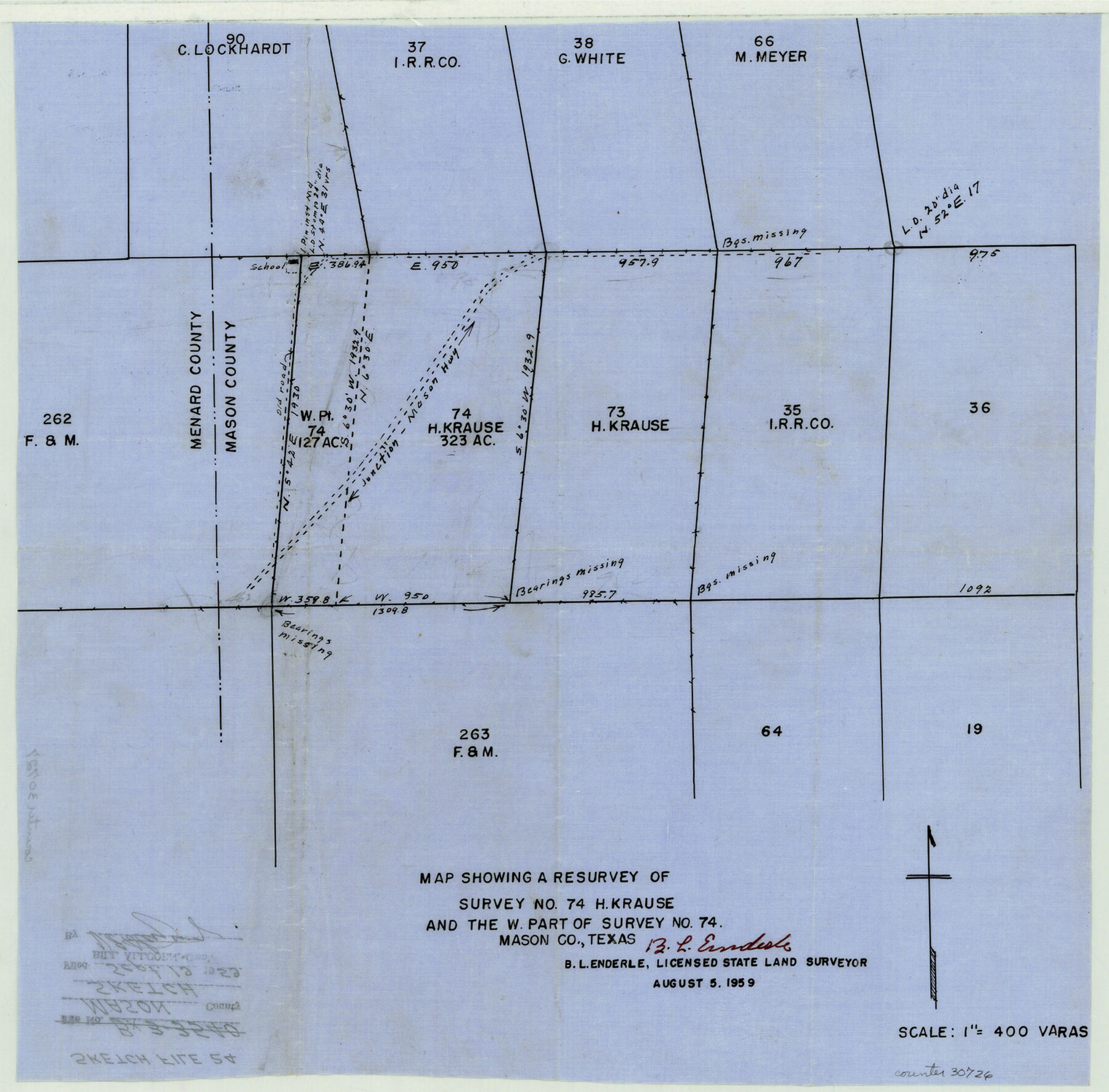
Map showing a resurvey of survey no. 74, H. Krause and the west part of survey no. 74
-
Map/Doc
30726
-
Collection
General Map Collection
-
Object Dates
8/5/1959 (Creation Date)
9/19/1959 (File Date)
-
People and Organizations
B.L. Enderle (Surveyor/Engineer)
-
Counties
Mason Menard
-
Subjects
Surveying Sketch File
-
Height x Width
15.0 x 15.2 inches
38.1 x 38.6 cm
-
Medium
paper, manuscript
-
Scale
1" = 400 varas
Part of: General Map Collection
Shackelford County Sketch File 14

Print $28.00
- Digital $50.00
Shackelford County Sketch File 14
1874
Size 14.4 x 8.8 inches
Map/Doc 36585
Flight Mission No. DQN-2K, Frame 143, Calhoun County

Print $20.00
- Digital $50.00
Flight Mission No. DQN-2K, Frame 143, Calhoun County
1953
Size 18.7 x 22.3 inches
Map/Doc 84312
Matagorda County Aerial Photograph Index Sheet 4

Print $20.00
- Digital $50.00
Matagorda County Aerial Photograph Index Sheet 4
1953
Size 23.6 x 19.5 inches
Map/Doc 83725

Jefferson County Rolled Sketch 37

Print $20.00
- Digital $50.00
Jefferson County Rolled Sketch 37
1957
Size 36.4 x 30.1 inches
Map/Doc 6396
Topographical Map of the Rio Grande, Sheet No. 24

Print $20.00
- Digital $50.00
Topographical Map of the Rio Grande, Sheet No. 24
1912
Map/Doc 89548
Ward County Rolled Sketch 26

Print $28.00
- Digital $50.00
Ward County Rolled Sketch 26
Size 9.9 x 15.0 inches
Map/Doc 49468
G No. 2 - Reconnaissance of Channel No. IV Cedar-Keys, Florida

Print $20.00
- Digital $50.00
G No. 2 - Reconnaissance of Channel No. IV Cedar-Keys, Florida
1852
Size 10.8 x 12.6 inches
Map/Doc 97220
Texas-Oklahoma (Indian Territory) Gainesville Quadrangle

Print $20.00
- Digital $50.00
Texas-Oklahoma (Indian Territory) Gainesville Quadrangle
1902
Size 21.2 x 17.2 inches
Map/Doc 75101
Flight Mission No. DCL-7C, Frame 42, Kenedy County

Print $20.00
- Digital $50.00
Flight Mission No. DCL-7C, Frame 42, Kenedy County
1943
Size 15.3 x 15.2 inches
Map/Doc 86030
Flight Mission No. CRC-3R, Frame 47, Chambers County

Print $20.00
- Digital $50.00
Flight Mission No. CRC-3R, Frame 47, Chambers County
1956
Size 18.6 x 22.3 inches
Map/Doc 84820
Baylor County Sketch File A4

Print $8.00
- Digital $50.00
Baylor County Sketch File A4
Size 14.0 x 8.7 inches
Map/Doc 14084
You may also like
Newton County Rolled Sketch 18

Print $40.00
- Digital $50.00
Newton County Rolled Sketch 18
1955
Size 41.6 x 59.2 inches
Map/Doc 9580
Galveston Bay Entrance - Galveston and Texas City Harbors

Print $40.00
- Digital $50.00
Galveston Bay Entrance - Galveston and Texas City Harbors
1975
Size 37.4 x 53.5 inches
Map/Doc 69864
Cass County Working Sketch 23

Print $40.00
- Digital $50.00
Cass County Working Sketch 23
1966
Size 56.8 x 37.1 inches
Map/Doc 67926
Flight Mission No. CUG-3P, Frame 141, Kleberg County

Print $20.00
- Digital $50.00
Flight Mission No. CUG-3P, Frame 141, Kleberg County
1956
Size 18.4 x 22.2 inches
Map/Doc 86276
Pecos County Rolled Sketch 64

Print $20.00
- Digital $50.00
Pecos County Rolled Sketch 64
Size 16.4 x 26.5 inches
Map/Doc 7235
General Highway Map, Crosby County, Texas

Print $20.00
General Highway Map, Crosby County, Texas
1961
Size 18.1 x 24.5 inches
Map/Doc 79426

Survey Map of Runnels County

Print $20.00
- Digital $50.00
Survey Map of Runnels County
Size 33.6 x 40.3 inches
Map/Doc 92918
[Surveying Sketch of H. & T. C. R.R. Co. surveys, et al, unknown county]
![75988, [Surveying Sketch of H. & T. C. R.R. Co. surveys, et al, unknown county], Maddox Collection](https://historictexasmaps.com/wmedia_w700/maps/75988.tif.jpg)
Print $20.00
- Digital $50.00
[Surveying Sketch of H. & T. C. R.R. Co. surveys, et al, unknown county]
Size 21.0 x 25.7 inches
Map/Doc 75988
Houston Ship Channel, Alexander Island to Carpenter Bayou

Print $20.00
- Digital $50.00
Houston Ship Channel, Alexander Island to Carpenter Bayou
1973
Size 35.6 x 46.3 inches
Map/Doc 69909
Rusk County Working Sketch 17

Print $20.00
- Digital $50.00
Rusk County Working Sketch 17
1955
Size 25.1 x 32.9 inches
Map/Doc 63652
McLennan County Boundary File 1

Print $80.00
- Digital $50.00
McLennan County Boundary File 1
Size 19.4 x 12.3 inches
Map/Doc 56937