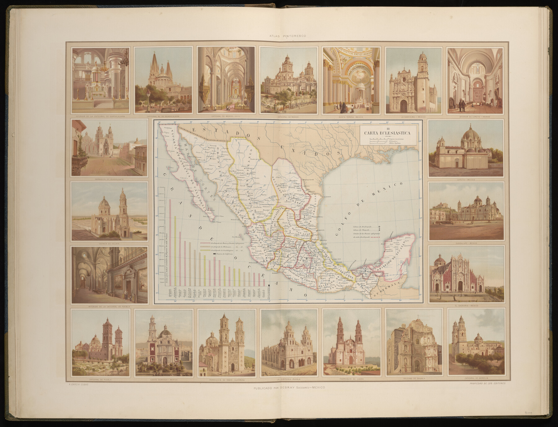
Carta Eclesiastica
-
Map/Doc
96799
-
Collection
General Map Collection
-
Object Dates
1897 (Creation Date)
-
People and Organizations
Debray Sucesores (Publisher)
Antonio Garcia Cubas (Cartographer)
-
Subjects
Atlas Mexico
-
Height x Width
26.1 x 34.1 inches
66.3 x 86.6 cm
-
Medium
paper, etching/engraving/lithograph
-
Comments
Map 3 of 13 from "Atlas Pintoresco e Historico de los Estados Unidos Mexicanos" (96796 - PDF)
Related maps
Atlas Pintoresco e Historico de los Estados Unidos Mexicanos

Atlas Pintoresco e Historico de los Estados Unidos Mexicanos
Map/Doc 96796
Part of: General Map Collection
Brazoria County NRC Article 33.136 Sketch 6

Print $22.00
- Digital $50.00
Brazoria County NRC Article 33.136 Sketch 6
2004
Size 24.6 x 35.2 inches
Map/Doc 82904
Rockwall County Boundary File 3

Print $22.00
- Digital $50.00
Rockwall County Boundary File 3
Size 14.4 x 8.7 inches
Map/Doc 58391
Llano County Sketch File 2

Print $6.00
- Digital $50.00
Llano County Sketch File 2
Size 9.6 x 8.6 inches
Map/Doc 30347
[Val Verde County]
![63096, [Val Verde County], General Map Collection](https://historictexasmaps.com/wmedia_w700/maps/63096.tif.jpg)
Print $20.00
- Digital $50.00
[Val Verde County]
1898
Size 42.6 x 34.9 inches
Map/Doc 63096
Wichita County Working Sketch 5

Print $20.00
- Digital $50.00
Wichita County Working Sketch 5
1913
Size 18.2 x 27.0 inches
Map/Doc 72514
Flight Mission No. BRA-8M, Frame 74, Jefferson County

Print $20.00
- Digital $50.00
Flight Mission No. BRA-8M, Frame 74, Jefferson County
1953
Size 18.6 x 22.2 inches
Map/Doc 85594
Caldwell County Working Sketch 4

Print $20.00
- Digital $50.00
Caldwell County Working Sketch 4
1922
Size 46.1 x 43.5 inches
Map/Doc 67834
Nueces County Rolled Sketch 63

Print $20.00
- Digital $50.00
Nueces County Rolled Sketch 63
1979
Size 25.5 x 38.1 inches
Map/Doc 6909
Edwards County Boundary File 27e

Print $11.00
- Digital $50.00
Edwards County Boundary File 27e
Size 12.8 x 8.5 inches
Map/Doc 52906
Hill County Rolled Sketch 1

Print $20.00
- Digital $50.00
Hill County Rolled Sketch 1
1950
Size 13.1 x 41.0 inches
Map/Doc 6214
Frio County Rolled Sketch 18

Print $20.00
- Digital $50.00
Frio County Rolled Sketch 18
1955
Size 41.2 x 43.4 inches
Map/Doc 8908
Nueces River, Corpus Christi Sheet No. 6

Print $6.00
- Digital $50.00
Nueces River, Corpus Christi Sheet No. 6
1938
Size 31.3 x 31.0 inches
Map/Doc 65095
You may also like
Louisiana and Texas Intracoastal Waterway Proposed Extension to Rio Grande Valley

Print $20.00
- Digital $50.00
Louisiana and Texas Intracoastal Waterway Proposed Extension to Rio Grande Valley
1941
Size 28.1 x 41.1 inches
Map/Doc 61891
Hutchinson County Rolled Sketch 40

Print $20.00
- Digital $50.00
Hutchinson County Rolled Sketch 40
1981
Size 25.7 x 37.3 inches
Map/Doc 6304
Clay County Boundary File 2

Print $6.00
- Digital $50.00
Clay County Boundary File 2
Size 10.5 x 8.2 inches
Map/Doc 51361
Right-of-Way and Track Map, Texas State Railroad operated by the T. and N. O. R.R. Co.

Print $40.00
- Digital $50.00
Right-of-Way and Track Map, Texas State Railroad operated by the T. and N. O. R.R. Co.
1917
Size 24.4 x 55.8 inches
Map/Doc 64174
Sutton County Working Sketch 54

Print $20.00
- Digital $50.00
Sutton County Working Sketch 54
1957
Size 28.0 x 38.4 inches
Map/Doc 62397
Map of Chambers County

Print $20.00
- Digital $50.00
Map of Chambers County
1896
Size 22.2 x 23.3 inches
Map/Doc 3385
Aransas County NRC Article 33.136 Location Key Sheet

Print $20.00
- Digital $50.00
Aransas County NRC Article 33.136 Location Key Sheet
1970
Size 27.0 x 23.0 inches
Map/Doc 87904

Roberts County Working Sketch 28

Print $20.00
- Digital $50.00
Roberts County Working Sketch 28
1983
Size 39.7 x 29.8 inches
Map/Doc 63554
Reagan County Rolled Sketch 40

Print $40.00
- Digital $50.00
Reagan County Rolled Sketch 40
Size 90.0 x 39.3 inches
Map/Doc 9831
Presidio County Rolled Sketch 82

Print $20.00
- Digital $50.00
Presidio County Rolled Sketch 82
1943
Size 35.5 x 26.1 inches
Map/Doc 7369
Flight Mission No. DIX-10P, Frame 168, Aransas County

Print $20.00
- Digital $50.00
Flight Mission No. DIX-10P, Frame 168, Aransas County
1956
Size 18.7 x 22.3 inches
Map/Doc 83958