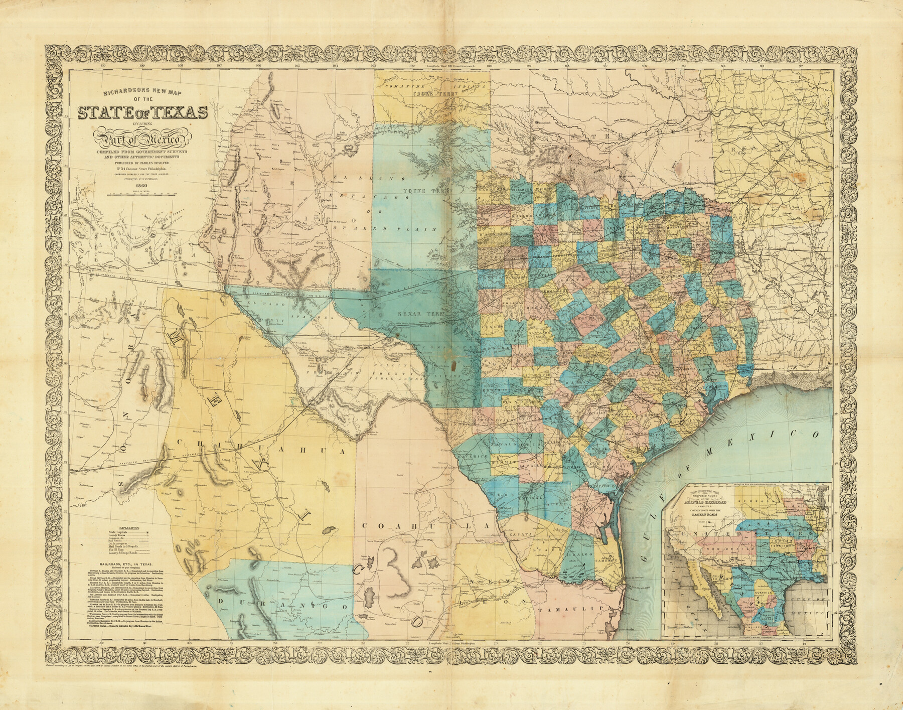
Richardson's New Map of the State of Texas Including Part of Mexico Compiled From Government Surveys and Other Authentic Documents
[Inset:] Map Showing the Proposed Route of the Aransas Railroad and its Connections With the Eastern Roads
-
Map/Doc
96788
-
Collection
Holcomb Digital Map Collection
-
Object Dates
1860 (Creation Date)
-
People and Organizations
Charles Desilver (Publisher)
H. Wickeland (Draftsman)
-
Subjects
State of Texas
-
Height x Width
28.5 x 36.3 inches
72.4 x 92.2 cm
-
Medium
digital image
-
Comments
Courtesy of Frank and Carol Holcomb.
Engraved expressly for the Texas Almanac. Corrected by H. Wickeland.
Part of: Holcomb Digital Map Collection
Map of the Texas & Pacific Railway and connections

Print $20.00
- Digital $50.00
Map of the Texas & Pacific Railway and connections
1902
Size 18.0 x 36.8 inches
Map/Doc 95413
Americae Sive Novi Orbis Nova Descriptio

Print $20.00
- Digital $50.00
Americae Sive Novi Orbis Nova Descriptio
1579
Size 18.0 x 22.9 inches
Map/Doc 93805
Map of Texas containing the latest Grants and Discoveries

Print $20.00
- Digital $50.00
Map of Texas containing the latest Grants and Discoveries
1836
Size 12.7 x 9.1 inches
Map/Doc 93855
Map and Description of Texas, containing sketches of its history, geology, geography and statistics: with concise statements, relative to the soil, climate, productions, facilities of transportation, population of the country;

Print $324.00
- Digital $50.00
Map and Description of Texas, containing sketches of its history, geology, geography and statistics: with concise statements, relative to the soil, climate, productions, facilities of transportation, population of the country;
1840
Size 6.1 x 4.1 inches
Map/Doc 93861
Map of the State of Texas from the Latest Authorities

Print $2.00
- Digital $50.00
Map of the State of Texas from the Latest Authorities
1854
Size 5.2 x 3.5 inches
Map/Doc 93902
Smith's Atlas designed to accompany the Geography

Print $352.00
- Digital $50.00
Smith's Atlas designed to accompany the Geography
1850
Size 12.2 x 10.0 inches
Map/Doc 93881
America sive novvs orbis respectv evropaeorvm inferior globi terrestris pars 1596

Print $20.00
- Digital $50.00
America sive novvs orbis respectv evropaeorvm inferior globi terrestris pars 1596
1596
Size 14.7 x 18.1 inches
Map/Doc 93809
America Settentrionale Colle Nuoue Scoperte fin all' Anno 1688

Print $20.00
- Digital $50.00
America Settentrionale Colle Nuoue Scoperte fin all' Anno 1688
1688
Size 25.4 x 37.6 inches
Map/Doc 96506
Amèrica noviter delineata

Print $20.00
- Digital $50.00
Amèrica noviter delineata
1630
Size 21.5 x 24.7 inches
Map/Doc 93814
Americae Nova Descriptio

Print $20.00
- Digital $50.00
Americae Nova Descriptio
1652
Size 19.7 x 23.5 inches
Map/Doc 95370
Die Neüwen Inseln / so hinder Hispanien gegen Orient bey dem Landt Indie ligen

Print $20.00
- Digital $50.00
Die Neüwen Inseln / so hinder Hispanien gegen Orient bey dem Landt Indie ligen
1540
Size 10.8 x 15.8 inches
Map/Doc 93831
A Map of Louisiana and Mexico

Print $20.00
- Digital $50.00
A Map of Louisiana and Mexico
1820
Size 43.8 x 32.9 inches
Map/Doc 94945
You may also like
Military Reconnaissance [showing forts along Rio Grande near Matamoros]
![72910, Military Reconnaissance [showing forts along Rio Grande near Matamoros], General Map Collection](https://historictexasmaps.com/wmedia_w700/maps/72910.tif.jpg)
Print $20.00
- Digital $50.00
Military Reconnaissance [showing forts along Rio Grande near Matamoros]
1846
Size 18.4 x 26.7 inches
Map/Doc 72910
Bosque County Boundary File 11

Print $10.00
- Digital $50.00
Bosque County Boundary File 11
Size 8.8 x 7.0 inches
Map/Doc 50689
Plat in Pecos County, Texas

Print $40.00
- Digital $50.00
Plat in Pecos County, Texas
1927
Size 57.9 x 37.0 inches
Map/Doc 89836
Ector County Rolled Sketch 14

Print $20.00
- Digital $50.00
Ector County Rolled Sketch 14
1957
Size 38.0 x 31.3 inches
Map/Doc 5779
[Blocks R31E-R33E, Townships 12E-14E]
![92041, [Blocks R31E-R33E, Townships 12E-14E], Twichell Survey Records](https://historictexasmaps.com/wmedia_w700/maps/92041-1.tif.jpg)
Print $20.00
- Digital $50.00
[Blocks R31E-R33E, Townships 12E-14E]
Size 22.9 x 21.4 inches
Map/Doc 92041
Hartley County Boundary File 4

Print $56.00
- Digital $50.00
Hartley County Boundary File 4
Size 8.6 x 20.7 inches
Map/Doc 54495
Kendall County Sketch File 11

Print $8.00
- Digital $50.00
Kendall County Sketch File 11
1924
Size 11.2 x 8.7 inches
Map/Doc 28695
General Highway Map, Sabine County, Texas

Print $20.00
General Highway Map, Sabine County, Texas
1961
Size 24.6 x 18.1 inches
Map/Doc 79644
Presidio County Rolled Sketch 126

Print $20.00
- Digital $50.00
Presidio County Rolled Sketch 126
1986
Size 27.8 x 39.4 inches
Map/Doc 7397
Gulf Oil Corp. Fishgide - Port O'Connor

Gulf Oil Corp. Fishgide - Port O'Connor
1960
Size 12.2 x 22.3 inches
Map/Doc 75983
Stonewall County Rolled Sketch 30

Print $20.00
- Digital $50.00
Stonewall County Rolled Sketch 30
Size 25.5 x 37.3 inches
Map/Doc 7874
Blanco County Sketch File 2

Print $5.00
- Digital $50.00
Blanco County Sketch File 2
Size 10.3 x 8.5 inches
Map/Doc 14580