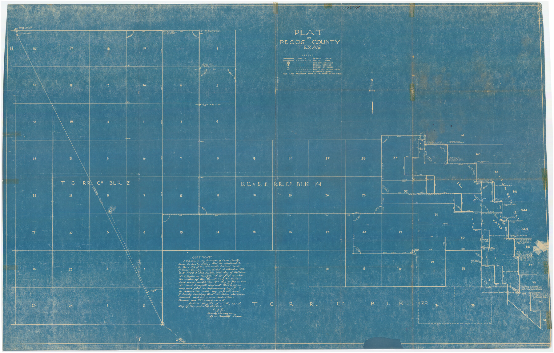
Plat in Pecos County, Texas
186-95
-
Map/Doc
89836
-
Collection
Twichell Survey Records
-
Object Dates
11/22/1927 (Creation Date)
-
People and Organizations
A.N. Lea (Surveyor/Engineer)
-
Counties
Pecos
-
Height x Width
57.9 x 37.0 inches
147.1 x 94.0 cm
Part of: Twichell Survey Records
W. D. McMillan Estate

Print $20.00
- Digital $50.00
W. D. McMillan Estate
1951
Size 18.0 x 23.1 inches
Map/Doc 92730
Nora Subdivision in NE 1/4 Section 8, Block B

Print $20.00
- Digital $50.00
Nora Subdivision in NE 1/4 Section 8, Block B
1950
Size 12.2 x 18.0 inches
Map/Doc 92309
Capitol Lands Surveyed by J. T. Munson

Print $20.00
- Digital $50.00
Capitol Lands Surveyed by J. T. Munson
Size 14.3 x 13.0 inches
Map/Doc 90511
[Sketch around O. A. Seward surveys]
![91991, [Sketch around O. A. Seward surveys], Twichell Survey Records](https://historictexasmaps.com/wmedia_w700/maps/91991-1.tif.jpg)
Print $20.00
- Digital $50.00
[Sketch around O. A. Seward surveys]
Size 23.4 x 23.9 inches
Map/Doc 91991
[Blocks M18, M23, I, Z, and Block 47, Sections 16 - 28]
![91175, [Blocks M18, M23, I, Z, and Block 47, Sections 16 - 28], Twichell Survey Records](https://historictexasmaps.com/wmedia_w700/maps/91175-1.tif.jpg)
Print $20.00
- Digital $50.00
[Blocks M18, M23, I, Z, and Block 47, Sections 16 - 28]
Size 18.9 x 24.3 inches
Map/Doc 91175
Lubbock Cemetery

Print $40.00
- Digital $50.00
Lubbock Cemetery
Size 42.2 x 53.7 inches
Map/Doc 89912
[Garza, Blanco, Uvalde and Crosby County School Land]
![90250, [Garza, Blanco, Uvalde and Crosby County School Land], Twichell Survey Records](https://historictexasmaps.com/wmedia_w700/maps/90250-1.tif.jpg)
Print $3.00
- Digital $50.00
[Garza, Blanco, Uvalde and Crosby County School Land]
1913
Size 14.6 x 11.8 inches
Map/Doc 90250
[H. & T. C. RR. Company, Block 47, Map C]
![91258, [H. & T. C. RR. Company, Block 47, Map C], Twichell Survey Records](https://historictexasmaps.com/wmedia_w700/maps/91258-1.tif.jpg)
Print $20.00
- Digital $50.00
[H. & T. C. RR. Company, Block 47, Map C]
Size 34.1 x 20.7 inches
Map/Doc 91258
[Block 47, Sections 17- 29]
![91176, [Block 47, Sections 17- 29], Twichell Survey Records](https://historictexasmaps.com/wmedia_w700/maps/91176-1.tif.jpg)
Print $20.00
- Digital $50.00
[Block 47, Sections 17- 29]
Size 25.2 x 18.4 inches
Map/Doc 91176
[Southwest part of County]
![90922, [Southwest part of County], Twichell Survey Records](https://historictexasmaps.com/wmedia_w700/maps/90922-1.tif.jpg)
Print $20.00
- Digital $50.00
[Southwest part of County]
Size 28.8 x 18.4 inches
Map/Doc 90922

McAdams-Lokey Land

Print $20.00
- Digital $50.00
McAdams-Lokey Land
Size 15.8 x 19.5 inches
Map/Doc 92773
You may also like
Medina County, Texas

Print $20.00
- Digital $50.00
Medina County, Texas
1879
Size 31.8 x 26.4 inches
Map/Doc 579
Topographical Map of the Rio Grande, Sheet No. 26

Print $20.00
- Digital $50.00
Topographical Map of the Rio Grande, Sheet No. 26
1912
Map/Doc 89550
Collin County Boundary File 18e

Print $16.00
- Digital $50.00
Collin County Boundary File 18e
Size 6.8 x 8.1 inches
Map/Doc 51749
Angelina County Working Sketch 30

Print $20.00
- Digital $50.00
Angelina County Working Sketch 30
1955
Size 26.2 x 27.7 inches
Map/Doc 67112
Moore County Sketch File 2

Print $36.00
- Digital $50.00
Moore County Sketch File 2
Size 14.2 x 8.6 inches
Map/Doc 31929
Atascosa County Working Sketch 27

Print $20.00
- Digital $50.00
Atascosa County Working Sketch 27
1963
Size 16.8 x 18.6 inches
Map/Doc 67223
Bowie County Sketch File 6c

Print $40.00
- Digital $50.00
Bowie County Sketch File 6c
1927
Size 20.1 x 16.1 inches
Map/Doc 10942
Lampasas County Sketch File 14

Print $6.00
- Digital $50.00
Lampasas County Sketch File 14
Size 16.2 x 10.5 inches
Map/Doc 29426
Taylor County Sketch File 12

Print $4.00
- Digital $50.00
Taylor County Sketch File 12
Size 8.6 x 12.8 inches
Map/Doc 37796
Flight Mission No. BRA-8M, Frame 73, Jefferson County

Print $20.00
- Digital $50.00
Flight Mission No. BRA-8M, Frame 73, Jefferson County
1953
Size 18.7 x 22.3 inches
Map/Doc 85593
Bee County Working Sketch 16

Print $20.00
- Digital $50.00
Bee County Working Sketch 16
1974
Size 18.0 x 19.6 inches
Map/Doc 67266
United States - Gulf Coast - From Latitude 26° 33' to the Rio Grande Texas

Print $20.00
- Digital $50.00
United States - Gulf Coast - From Latitude 26° 33' to the Rio Grande Texas
1913
Size 27.8 x 18.4 inches
Map/Doc 72831