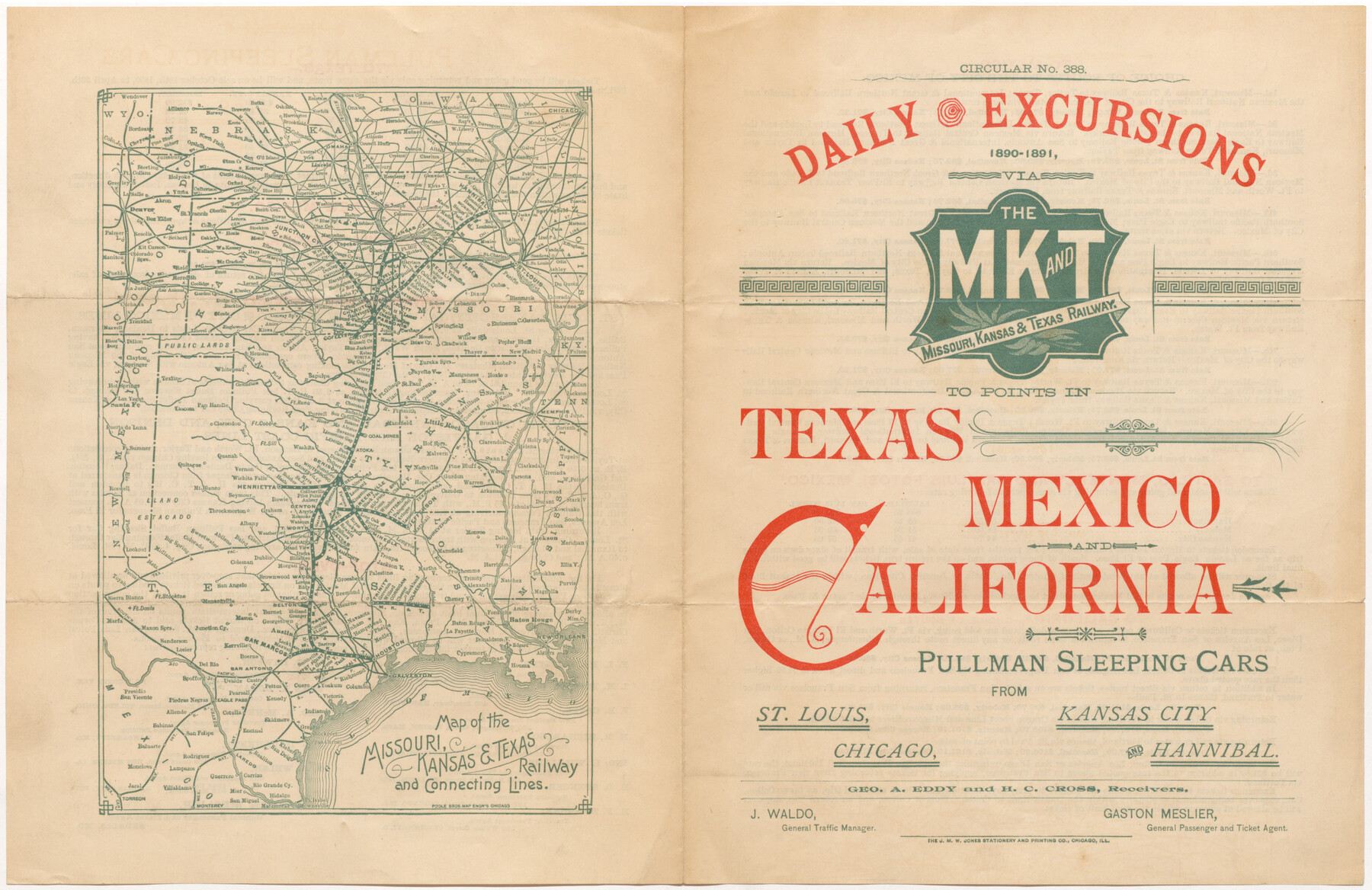
Map of the Missouri, Kansas, & Texas Railway and Connecting Lines
-
Map/Doc
96599
-
Collection
Cobb Digital Map Collection
-
People and Organizations
Poole Bros. (Publisher)
The J.M.W. Jones Stationary and Printing Co. (Printer)
-
Subjects
Railroads
-
Height x Width
11.2 x 17.2 inches
28.5 x 43.7 cm
-
Medium
digital image
-
Comments
Courtesy of John & Diana Cobb.
For related information on verso, click the "Download PDF" link above.
Part of: Cobb Digital Map Collection
Sectional map of Texas traversed by the Missouri, Kansas & Texas Railway, showing the crops adapted to each section, with the elevation and annual rainfall

Print $20.00
- Digital $50.00
Sectional map of Texas traversed by the Missouri, Kansas & Texas Railway, showing the crops adapted to each section, with the elevation and annual rainfall
Size 21.9 x 22.8 inches
Map/Doc 95818
Panhandle of Texas

Print $20.00
- Digital $50.00
Panhandle of Texas
1907
Size 11.4 x 14.4 inches
Map/Doc 95889
The Great Texas Route via the Beautiful Indian Territory / The Great Kansas Route via the Picturesque Valley of the Neosho

Print $20.00
- Digital $50.00
The Great Texas Route via the Beautiful Indian Territory / The Great Kansas Route via the Picturesque Valley of the Neosho
1876
Size 12.1 x 17.4 inches
Map/Doc 95804
Missouri, Kansas, & Texas Ry.

Print $20.00
- Digital $50.00
Missouri, Kansas, & Texas Ry.
Size 6.7 x 5.4 inches
Map/Doc 96598
Geographically Correct County Map showing the lines of the Cotton Belt Route and connections

Print $20.00
- Digital $50.00
Geographically Correct County Map showing the lines of the Cotton Belt Route and connections
1902
Size 35.9 x 30.7 inches
Map/Doc 95840
Colonists' and Emigrants' Route to Texas

Print $20.00
- Digital $50.00
Colonists' and Emigrants' Route to Texas
1878
Size 14.8 x 23.7 inches
Map/Doc 95777
The Texas Panhandle Route from Summerland to the American Alps

The Texas Panhandle Route from Summerland to the American Alps
1892
Size 7.9 x 6.3 inches
Map/Doc 96584
A Fourteen Day Trip for $99.50 through the Great Southwest and the Gulf Coast Country of Texas

A Fourteen Day Trip for $99.50 through the Great Southwest and the Gulf Coast Country of Texas
1912
Map/Doc 96772
Map showing Alamo-Donna Farms, Irrigated Section in Hidalgo County, Texas

Print $20.00
- Digital $50.00
Map showing Alamo-Donna Farms, Irrigated Section in Hidalgo County, Texas
1920
Size 27.5 x 13.3 inches
Map/Doc 95803

Texas, the Empire State of the Southwest

Texas, the Empire State of the Southwest
1909
Size 9.7 x 5.4 inches
Map/Doc 96603
Map of the Lower Rio Grande Valley showing Alamo-Donna Farms

Print $20.00
- Digital $50.00
Map of the Lower Rio Grande Valley showing Alamo-Donna Farms
1920
Size 14.0 x 13.4 inches
Map/Doc 95801
You may also like
Childress County Rolled Sketch 18A

Print $20.00
- Digital $50.00
Childress County Rolled Sketch 18A
1913
Size 18.5 x 39.8 inches
Map/Doc 5452
Gregg County Sketch File 14

Print $6.00
- Digital $50.00
Gregg County Sketch File 14
1946
Size 14.3 x 8.8 inches
Map/Doc 24613
Map of Wilbarger County, Texas

Print $20.00
Map of Wilbarger County, Texas
1887
Size 11.8 x 8.7 inches
Map/Doc 93587
[Strip between Block 8 and Block K4]
![90525, [Strip between Block 8 and Block K4], Twichell Survey Records](https://historictexasmaps.com/wmedia_w700/maps/90525-1.tif.jpg)
Print $2.00
- Digital $50.00
[Strip between Block 8 and Block K4]
Size 5.7 x 7.5 inches
Map/Doc 90525
[John Welch, W. F. Butter, and surrounding surveys]
![91011, [John Welch, W. F. Butter, and surrounding surveys], Twichell Survey Records](https://historictexasmaps.com/wmedia_w700/maps/91011-1.tif.jpg)
Print $3.00
- Digital $50.00
[John Welch, W. F. Butter, and surrounding surveys]
Size 17.1 x 10.9 inches
Map/Doc 91011
Webb County Rolled Sketch 54

Print $20.00
- Digital $50.00
Webb County Rolled Sketch 54
1935
Size 24.8 x 18.6 inches
Map/Doc 8207
Flight Mission No. BQR-5K, Frame 65, Brazoria County

Print $20.00
- Digital $50.00
Flight Mission No. BQR-5K, Frame 65, Brazoria County
1952
Size 18.8 x 22.5 inches
Map/Doc 84010
Childress Co.
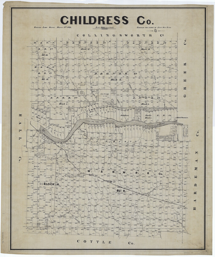
Print $20.00
- Digital $50.00
Childress Co.
1892
Size 40.3 x 33.7 inches
Map/Doc 66752
Gaines County, Texas

Print $40.00
- Digital $50.00
Gaines County, Texas
1915
Size 54.1 x 33.0 inches
Map/Doc 89843
Starr County Sketch File 32B

Print $20.00
- Digital $50.00
Starr County Sketch File 32B
1938
Size 19.9 x 21.5 inches
Map/Doc 12336
Gregg County Sketch File 1B

Print $4.00
- Digital $50.00
Gregg County Sketch File 1B
1848
Size 12.8 x 8.4 inches
Map/Doc 24538
Fort Bend County Working Sketch 26

Print $20.00
- Digital $50.00
Fort Bend County Working Sketch 26
1982
Size 18.5 x 23.6 inches
Map/Doc 69232