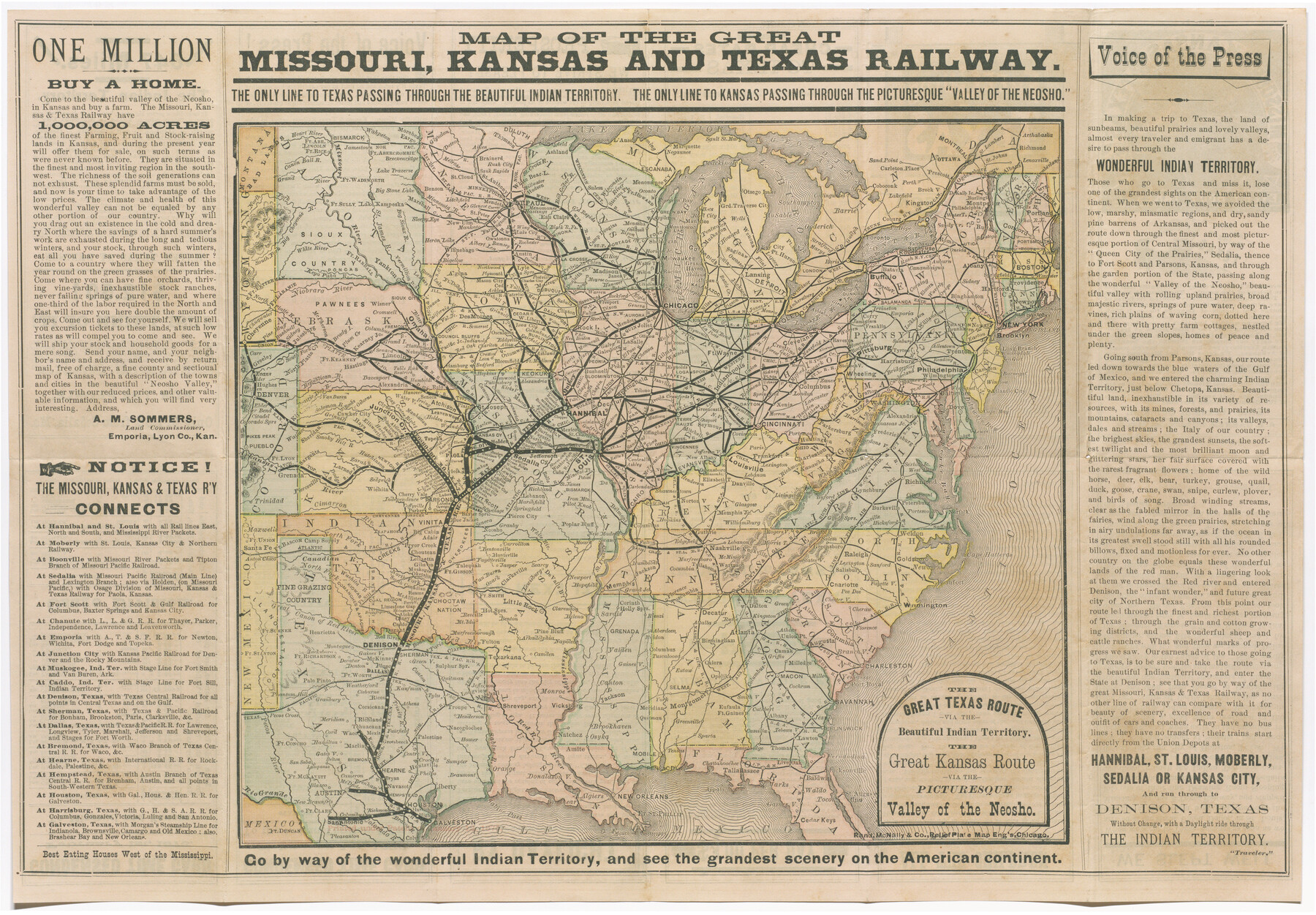
The Great Texas Route via the Beautiful Indian Territory / The Great Kansas Route via the Picturesque Valley of the Neosho
Map of the Great Missouri, Kansas and Texas Railway
-
Map/Doc
95804
-
Collection
Cobb Digital Map Collection
-
Object Dates
1876 (Creation Date)
-
People and Organizations
Rand, McNally & Co. (Printer)
-
Subjects
Railroads
-
Height x Width
12.1 x 17.4 inches
30.7 x 44.2 cm
-
Medium
digital image
-
Comments
Courtesy of John & Diana Cobb.
To view timetables and other information printed on verso, click "Download PDF" link above.
Part of: Cobb Digital Map Collection
Map showing those portions of Texas traversed by the Rock Island System and connecting lines

Print $20.00
- Digital $50.00
Map showing those portions of Texas traversed by the Rock Island System and connecting lines
1903
Size 16.4 x 24.0 inches
Map/Doc 96587
Correct Map of the Railway & Steamship Lines operated by the Southern Pacific Company

Print $20.00
- Digital $50.00
Correct Map of the Railway & Steamship Lines operated by the Southern Pacific Company
1893
Size 16.7 x 40.1 inches
Map/Doc 95762
San Antonio, Texas - The Great Winter Resort of the South

San Antonio, Texas - The Great Winter Resort of the South
1930
Size 6.6 x 3.5 inches
Map/Doc 97046


Rand, McNally & Co.'s Texas

Print $20.00
- Digital $50.00
Rand, McNally & Co.'s Texas
1895
Size 21.2 x 28.6 inches
Map/Doc 95885
Map of the Houston & Texas Central Railway and connections

Print $20.00
- Digital $50.00
Map of the Houston & Texas Central Railway and connections
1871
Size 16.6 x 15.4 inches
Map/Doc 95753
Wright's Special Train between Kansas City and the Panhandle Country

Wright's Special Train between Kansas City and the Panhandle Country
1906
Map/Doc 96752
The Newest Land Of Promise - The Pecos Valley in Texas

Print $20.00
- Digital $50.00
The Newest Land Of Promise - The Pecos Valley in Texas
1900
Size 17.8 x 22.9 inches
Map/Doc 97038


The Lower Valley of the Rio Grande Irrigated Farm Lands

Print $20.00
- Digital $50.00
The Lower Valley of the Rio Grande Irrigated Farm Lands
1918
Size 24.6 x 18.6 inches
Map/Doc 96729
You may also like
Bee County Sketch File 34

Print $14.00
Bee County Sketch File 34
2022
Size 11.0 x 8.5 inches
Map/Doc 97030
[T. & N. O. Railroad Company Blocks 2T and 3T]
![91489, [T. & N. O. Railroad Company Blocks 2T and 3T], Twichell Survey Records](https://historictexasmaps.com/wmedia_w700/maps/91489-1.tif.jpg)
Print $20.00
- Digital $50.00
[T. & N. O. Railroad Company Blocks 2T and 3T]
Size 24.4 x 8.8 inches
Map/Doc 91489
Flight Mission No. BQR-22K, Frame 40, Brazoria County

Print $20.00
- Digital $50.00
Flight Mission No. BQR-22K, Frame 40, Brazoria County
1953
Size 18.6 x 22.3 inches
Map/Doc 84124
Presidio County Working Sketch 72

Print $20.00
- Digital $50.00
Presidio County Working Sketch 72
1962
Size 22.1 x 21.1 inches
Map/Doc 71749
Harris County Sketch File 63

Print $21.00
- Digital $50.00
Harris County Sketch File 63
Size 4.3 x 6.4 inches
Map/Doc 25493
Comanche County Working Sketch 32

Print $20.00
- Digital $50.00
Comanche County Working Sketch 32
1992
Size 23.5 x 38.8 inches
Map/Doc 68166
Map of the Land Purchased by C.W. Post from the US, T, and OS Ranches situated in Garza and Lynn Counties, Texas

Print $40.00
- Digital $50.00
Map of the Land Purchased by C.W. Post from the US, T, and OS Ranches situated in Garza and Lynn Counties, Texas
Size 47.6 x 57.4 inches
Map/Doc 89948
Borden County Working Sketch 6

Print $20.00
- Digital $50.00
Borden County Working Sketch 6
1944
Size 24.6 x 23.0 inches
Map/Doc 67466
Kent County Boundary File 1

Print $54.00
- Digital $50.00
Kent County Boundary File 1
Size 14.2 x 8.5 inches
Map/Doc 55795
Carte d'une partie de la Syrie et de la Palestine

Print $20.00
- Digital $50.00
Carte d'une partie de la Syrie et de la Palestine
1782
Size 12.8 x 17.9 inches
Map/Doc 97121
Sutton County Working Sketch 23

Print $20.00
- Digital $50.00
Sutton County Working Sketch 23
1981
Size 17.3 x 27.1 inches
Map/Doc 62366
Flight Mission No. DQN-2K, Frame 157, Calhoun County

Print $20.00
- Digital $50.00
Flight Mission No. DQN-2K, Frame 157, Calhoun County
1953
Size 18.5 x 22.2 inches
Map/Doc 84319