Santa Fe
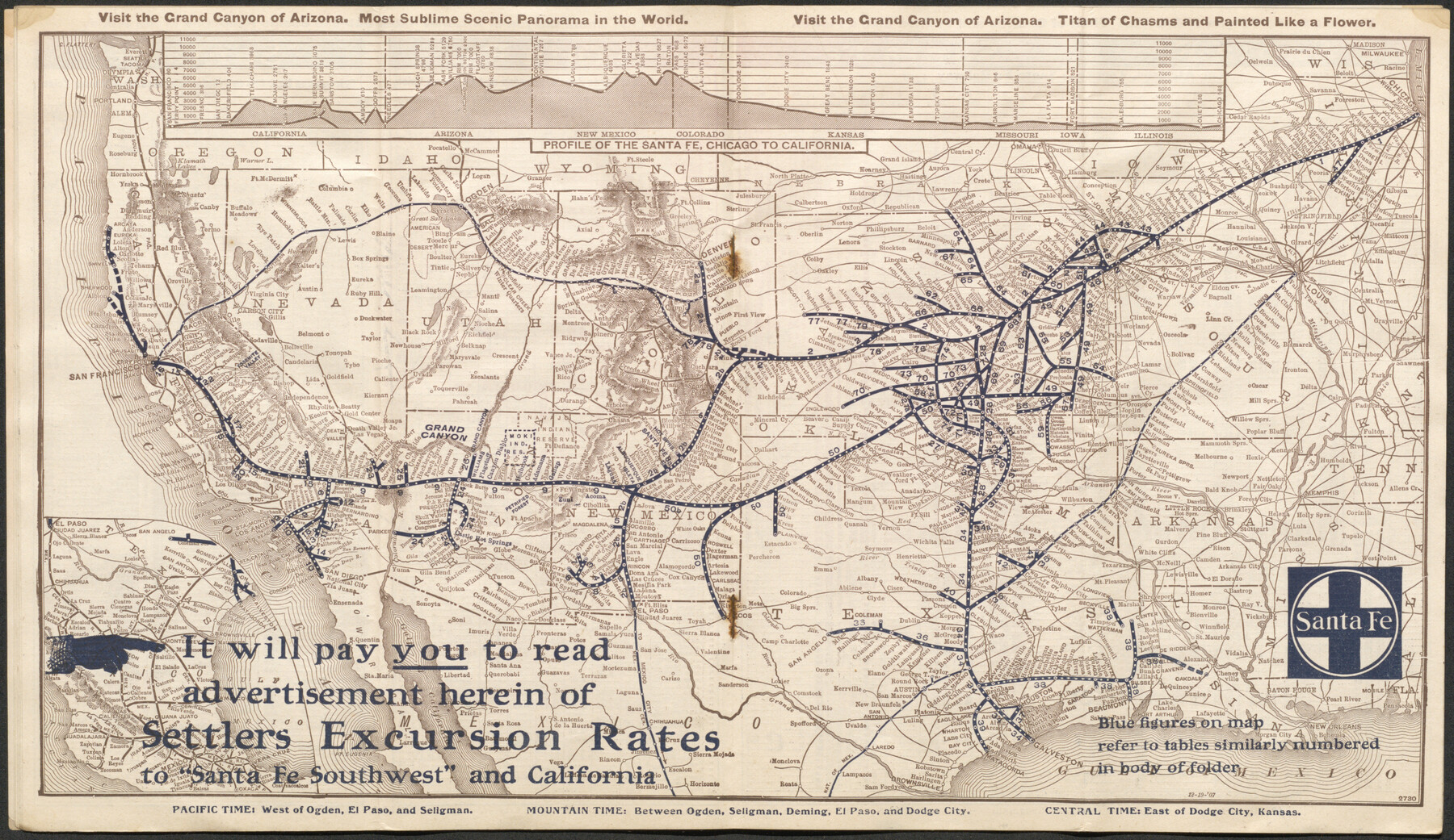
The Atchison, Topeka & Santa Fe Railway System and connecting lines
-
Map/Doc
96591
-
Collection
Cobb Digital Map Collection
-
Object Dates
12/19/1907 (Creation Date)
-
Subjects
Railroads United States
-
Height x Width
9.4 x 16.2 inches
23.9 x 41.2 cm
-
Medium
digital image
-
Comments
Courtesy of John & Diana Cobb.
To view full booklet in which this map was contained, click the "Download PDF" link above.
Part of: Cobb Digital Map Collection

Map of the St. Louis, Iron Mountain and Southern Railway, and connections

Print $20.00
- Digital $50.00
Map of the St. Louis, Iron Mountain and Southern Railway, and connections
1880
Size 10.5 x 14.4 inches
Map/Doc 95786
[The Frisco Line - St. Louis & San Francisco Railway through the Great West and South West]
![95794, [The Frisco Line - St. Louis & San Francisco Railway through the Great West and South West], Cobb Digital Map Collection - 1](https://historictexasmaps.com/wmedia_w700/maps/95794.tif.jpg)
Print $20.00
- Digital $50.00
[The Frisco Line - St. Louis & San Francisco Railway through the Great West and South West]
1893
Size 16.8 x 40.2 inches
Map/Doc 95794
Through Storyland to Sunset Seas

Through Storyland to Sunset Seas
1895
Size 8.9 x 6.7 inches
Map/Doc 96606
The MKT - Texas Empire of the South

Print $20.00
- Digital $50.00
The MKT - Texas Empire of the South
1905
Size 18.6 x 40.6 inches
Map/Doc 97034
Map of the Missouri Pacific and St. Louis, Iron Mountain and Southern Railways and Connections

Print $20.00
- Digital $50.00
Map of the Missouri Pacific and St. Louis, Iron Mountain and Southern Railways and Connections
1898
Size 17.7 x 32.1 inches
Map/Doc 95791
Map of Texas with population and location of principal towns and cities according to latest reliable statistics

Print $20.00
- Digital $50.00
Map of Texas with population and location of principal towns and cities according to latest reliable statistics
1906
Size 18.6 x 20.5 inches
Map/Doc 95871
State of Texas showing the Lower Rio Grande Valley

Print $20.00
- Digital $50.00
State of Texas showing the Lower Rio Grande Valley
1920
Size 14.0 x 13.4 inches
Map/Doc 95802

Southern Homes in Southern Texas, The Celebrated Coast Country

Southern Homes in Southern Texas, The Celebrated Coast Country
1899
Size 6.2 x 3.7 inches
Map/Doc 97050
Sectional map of Central and Eastern Texas traversed by the Missouri, Kansas & Texas Railway, showing the crops adapted to each section, with the elevation and average annual rainfall

Print $20.00
- Digital $50.00
Sectional map of Central and Eastern Texas traversed by the Missouri, Kansas & Texas Railway, showing the crops adapted to each section, with the elevation and average annual rainfall
1902
Size 19.7 x 16.2 inches
Map/Doc 95812
"Iron Mountain Route" to all parts of Texas - I. & G. N., T. & P., Iron Mountain - "The Way to Texas"

Print $20.00
- Digital $50.00
"Iron Mountain Route" to all parts of Texas - I. & G. N., T. & P., Iron Mountain - "The Way to Texas"
1909
Size 22.0 x 24.0 inches
Map/Doc 95792
You may also like
McMullen County Sketch File 35

Print $10.00
- Digital $50.00
McMullen County Sketch File 35
Size 9.7 x 8.5 inches
Map/Doc 31402
Reeves County Working Sketch 64

Print $20.00
- Digital $50.00
Reeves County Working Sketch 64
1984
Size 26.3 x 26.5 inches
Map/Doc 63507
Mills County Sketch File 6

Print $4.00
- Digital $50.00
Mills County Sketch File 6
Size 9.0 x 9.8 inches
Map/Doc 31655
Floyd County Working Sketch Graphic Index

Print $20.00
- Digital $50.00
Floyd County Working Sketch Graphic Index
1933
Size 44.9 x 38.4 inches
Map/Doc 76543
Fisher County Working Sketch 15

Print $20.00
- Digital $50.00
Fisher County Working Sketch 15
1958
Size 22.2 x 22.6 inches
Map/Doc 69149
United States - Gulf Coast - Aransas Pass and Corpus Christi Bay with the coast to latitude 27° 12' Texas

Print $20.00
- Digital $50.00
United States - Gulf Coast - Aransas Pass and Corpus Christi Bay with the coast to latitude 27° 12' Texas
1913
Size 27.5 x 18.3 inches
Map/Doc 72794
Falls County Sketch File 24

Print $4.00
- Digital $50.00
Falls County Sketch File 24
1859
Size 13.1 x 8.2 inches
Map/Doc 22428
Real County Working Sketch 74

Print $20.00
- Digital $50.00
Real County Working Sketch 74
1979
Size 17.1 x 23.5 inches
Map/Doc 71966
Wichita County Working Sketch 1

Print $20.00
- Digital $50.00
Wichita County Working Sketch 1
Size 23.5 x 24.2 inches
Map/Doc 72510
The Chief Justice County of Washington. Undated

Print $20.00
The Chief Justice County of Washington. Undated
2020
Size 13.0 x 21.7 inches
Map/Doc 96077
Photo Index of Texas Coast - Sheet 2 of 6

Print $20.00
- Digital $50.00
Photo Index of Texas Coast - Sheet 2 of 6
1954
Size 20.0 x 24.0 inches
Map/Doc 83439
[San Augustine County School Land]
![91331, [San Augustine County School Land], Twichell Survey Records](https://historictexasmaps.com/wmedia_w700/maps/91331-1.tif.jpg)
Print $3.00
- Digital $50.00
[San Augustine County School Land]
Size 9.3 x 11.6 inches
Map/Doc 91331