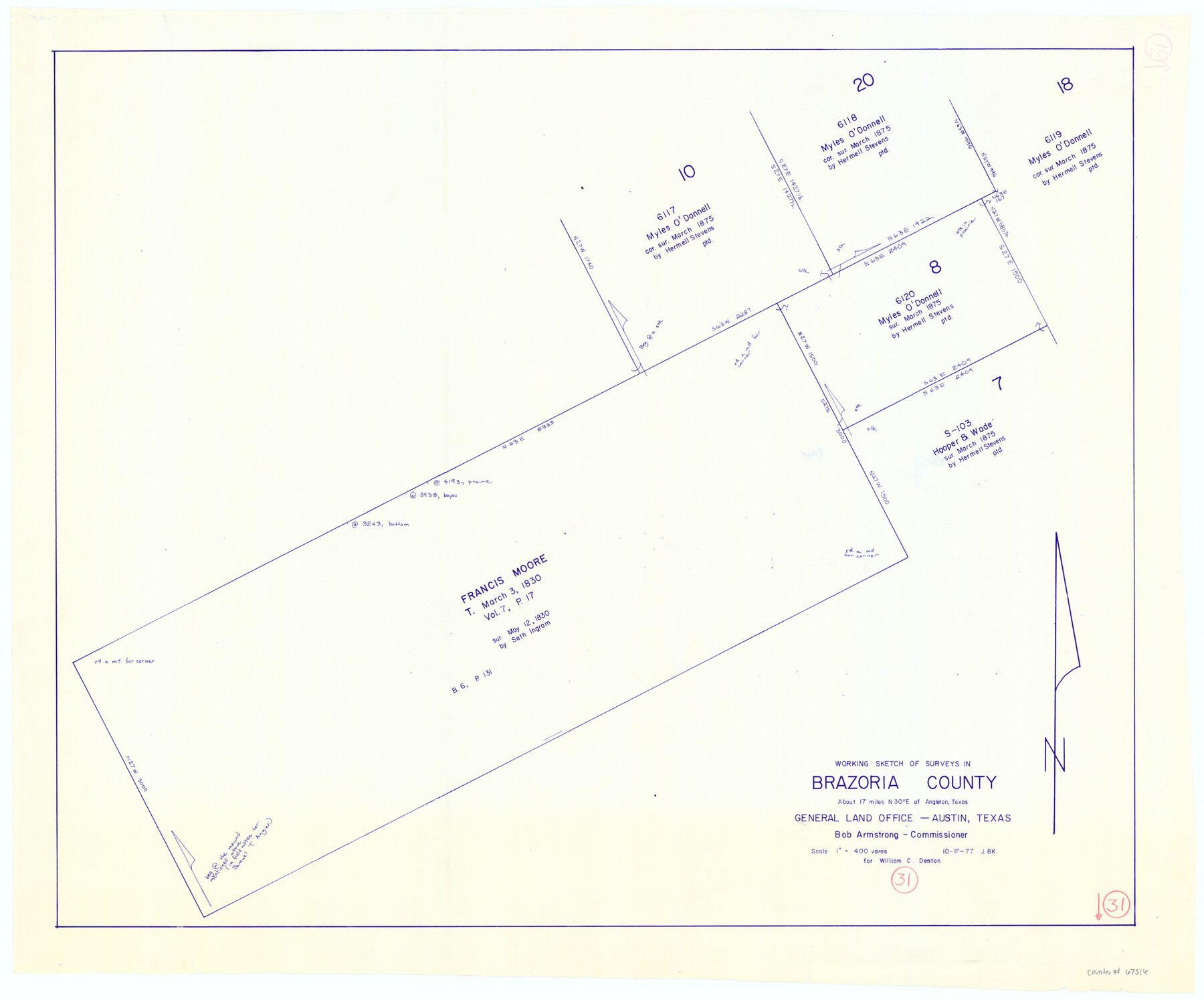
Brazoria County Working Sketch 31
-
Map/Doc
67516
-
Collection
General Map Collection
-
Object Dates
10/17/1977 (Creation Date)
-
People and Organizations
Bob Armstrong (GLO Commissioner)
Joan Kilpatrick (Draftsman)
-
Counties
Brazoria
-
Subjects
Surveying Working Sketch
-
Height x Width
26.3 x 31.7 inches
66.8 x 80.5 cm
-
Scale
1" = 400 varas
-
Comments
Surveys located about 17 miles North 30 degrees East of Angleton, Texas.
Part of: General Map Collection
Brazos River, Brazos River Sheet 3

Print $6.00
- Digital $50.00
Brazos River, Brazos River Sheet 3
1926
Size 23.6 x 35.2 inches
Map/Doc 65295
Flight Mission No. BRE-2P, Frame 19, Nueces County

Print $20.00
- Digital $50.00
Flight Mission No. BRE-2P, Frame 19, Nueces County
1956
Size 18.4 x 22.2 inches
Map/Doc 86728
Flight Mission No. CGI-1N, Frame 220, Cameron County

Print $20.00
- Digital $50.00
Flight Mission No. CGI-1N, Frame 220, Cameron County
1955
Size 18.5 x 22.1 inches
Map/Doc 84529
Montgomery County Sketch File 11

Print $4.00
- Digital $50.00
Montgomery County Sketch File 11
1872
Size 6.7 x 7.9 inches
Map/Doc 31800
Map of Angelina County
Print $40.00
- Digital $50.00
Map of Angelina County
1899
Size 39.1 x 52.3 inches
Map/Doc 4777

Fayette County Working Sketch 6

Print $20.00
- Digital $50.00
Fayette County Working Sketch 6
1981
Size 17.0 x 15.1 inches
Map/Doc 69170
Webb County Rolled Sketch 63

Print $20.00
- Digital $50.00
Webb County Rolled Sketch 63
1948
Size 39.4 x 37.0 inches
Map/Doc 10129
Matagorda Bay and Peninsula from Matagorda Oyster Lake

Print $40.00
- Digital $50.00
Matagorda Bay and Peninsula from Matagorda Oyster Lake
1915
Size 33.1 x 62.0 inches
Map/Doc 69981

Wharton County

Print $20.00
- Digital $50.00
Wharton County
1946
Size 41.4 x 46.9 inches
Map/Doc 77455
Tom Green County Sketch File 75

Print $20.00
- Digital $50.00
Tom Green County Sketch File 75
1950
Size 18.1 x 22.5 inches
Map/Doc 12449
You may also like
Copy of Surveyor's Field Book, Morris Browning - In Blocks 7, 5 & 4, I&GNRRCo., Hutchinson and Carson Counties, Texas

Print $2.00
- Digital $50.00
Copy of Surveyor's Field Book, Morris Browning - In Blocks 7, 5 & 4, I&GNRRCo., Hutchinson and Carson Counties, Texas
1888
Size 7.0 x 8.8 inches
Map/Doc 62272
Howard County Rolled Sketch 6

Print $20.00
- Digital $50.00
Howard County Rolled Sketch 6
Size 17.3 x 18.1 inches
Map/Doc 6235

Terrell County Working Sketch 76

Print $20.00
- Digital $50.00
Terrell County Working Sketch 76
1982
Size 31.8 x 20.1 inches
Map/Doc 69597
Pecos County Working Sketch 35

Print $20.00
- Digital $50.00
Pecos County Working Sketch 35
1939
Size 32.5 x 26.7 inches
Map/Doc 71507
Mississippi River to Galveston

Print $40.00
- Digital $50.00
Mississippi River to Galveston
1966
Size 37.0 x 49.8 inches
Map/Doc 69945
Wilbarger County Aerial Photograph Index Sheet 3

Print $20.00
- Digital $50.00
Wilbarger County Aerial Photograph Index Sheet 3
1950
Size 22.5 x 18.9 inches
Map/Doc 83752
[Block C-41, Sections 32, 35, 35 1/2, and vicinity]
![92569, [Block C-41, Sections 32, 35, 35 1/2, and vicinity], Twichell Survey Records](https://historictexasmaps.com/wmedia_w700/maps/92569-1.tif.jpg)
Print $20.00
- Digital $50.00
[Block C-41, Sections 32, 35, 35 1/2, and vicinity]
Size 23.8 x 19.4 inches
Map/Doc 92569
Culberson County Sketch File 18

Print $8.00
- Digital $50.00
Culberson County Sketch File 18
Size 14.3 x 8.8 inches
Map/Doc 20185
Flight Mission No. CRE-2R, Frame 169, Jackson County

Print $20.00
- Digital $50.00
Flight Mission No. CRE-2R, Frame 169, Jackson County
1956
Size 18.6 x 22.3 inches
Map/Doc 85379
Record of Spanish Titles, Vol. IV

Record of Spanish Titles, Vol. IV
Size 19.2 x 12.8 inches
Map/Doc 94529
Morris County Rolled Sketch 2A

Print $20.00
- Digital $50.00
Morris County Rolled Sketch 2A
Size 36.0 x 25.0 inches
Map/Doc 10236