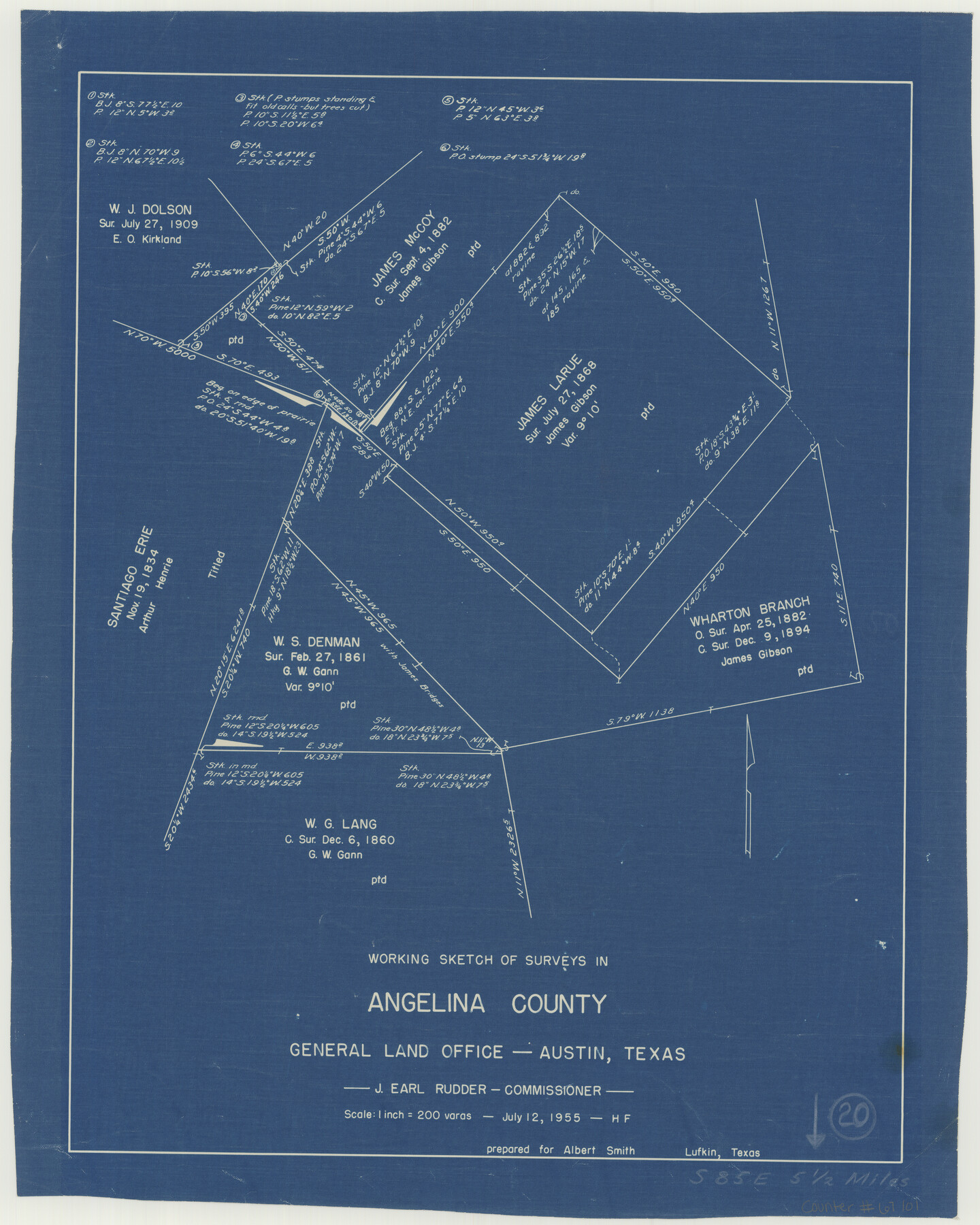
Angelina County Working Sketch 20
-
Map/Doc
67101
-
Collection
General Map Collection
-
Object Dates
7/12/1955 (Creation Date)
-
People and Organizations
Herman Forbes (Draftsman)
J. Earl Rudder (GLO Commissioner)
-
Counties
Angelina
-
Subjects
Surveying Working Sketch
-
Height x Width
18.8 x 15.0 inches
47.8 x 38.1 cm
-
Scale
1" = 200 varas
-
Comments
Surveys located about five and one half miles South 85 degrees East from Lufkin, Texas.
Part of: General Map Collection
[Sketch of Oyster Bay, Bastrop Bay, Chocolate Bay, and West Bay]
![3103, [Sketch of Oyster Bay, Bastrop Bay, Chocolate Bay, and West Bay], General Map Collection](https://historictexasmaps.com/wmedia_w700/maps/3103.tif.jpg)
Print $20.00
- Digital $50.00
[Sketch of Oyster Bay, Bastrop Bay, Chocolate Bay, and West Bay]
1871
Size 6.0 x 23.9 inches
Map/Doc 3103
San Jacinto County Sketch File 5

Print $2.00
San Jacinto County Sketch File 5
1848
Size 8.1 x 14.5 inches
Map/Doc 35702
San Patricio County Rolled Sketch BB

Print $40.00
- Digital $50.00
San Patricio County Rolled Sketch BB
1936
Size 25.0 x 49.0 inches
Map/Doc 9889
Flight Mission No. DQO-8K, Frame 56, Galveston County

Print $20.00
- Digital $50.00
Flight Mission No. DQO-8K, Frame 56, Galveston County
1952
Size 18.7 x 17.6 inches
Map/Doc 85163
Kleberg County Aerial Photograph Index Sheet 1

Print $20.00
- Digital $50.00
Kleberg County Aerial Photograph Index Sheet 1
1956
Size 19.6 x 23.6 inches
Map/Doc 83718

Duval County Sketch File 30

Print $20.00
- Digital $50.00
Duval County Sketch File 30
1932
Size 14.7 x 23.7 inches
Map/Doc 11388
Nacogdoches County Working Sketch 2

Print $20.00
- Digital $50.00
Nacogdoches County Working Sketch 2
1904
Size 20.5 x 24.1 inches
Map/Doc 71218
[Sketch of expeditions, trails in Jones, Taylor, Shackelford, Callahan, Buchanan/Stephens and Eastland Counties]
![65406, [Sketch of expeditions, trails in Jones, Taylor, Shackelford, Callahan, Buchanan/Stephens and Eastland Counties], General Map Collection](https://historictexasmaps.com/wmedia_w700/maps/65406.tif.jpg)
Print $4.00
- Digital $50.00
[Sketch of expeditions, trails in Jones, Taylor, Shackelford, Callahan, Buchanan/Stephens and Eastland Counties]
1873
Size 10.7 x 18.1 inches
Map/Doc 65406
Denton County Working Sketch 24

Print $20.00
- Digital $50.00
Denton County Working Sketch 24
1989
Size 22.2 x 30.0 inches
Map/Doc 68629
Rusk County Working Sketch 37b

Print $40.00
- Digital $50.00
Rusk County Working Sketch 37b
2007
Size 50.0 x 31.0 inches
Map/Doc 87497
Yoakum County Sketch File 17

Print $48.00
- Digital $50.00
Yoakum County Sketch File 17
1898
Size 14.5 x 8.9 inches
Map/Doc 40796
You may also like
Bexar County Boundary File 2

Print $32.00
- Digital $50.00
Bexar County Boundary File 2
Size 8.4 x 4.0 inches
Map/Doc 50518
Texas-United States Boundary Line 2

Print $22.00
- Digital $50.00
Texas-United States Boundary Line 2
1882
Size 8.3 x 7.3 inches
Map/Doc 74976
San Jacinto River and Tributaries, Texas - Survey of 1939

Print $20.00
- Digital $50.00
San Jacinto River and Tributaries, Texas - Survey of 1939
1939
Size 27.8 x 40.7 inches
Map/Doc 60308
Culberson County Rolled Sketch 17

Print $20.00
- Digital $50.00
Culberson County Rolled Sketch 17
1904
Size 22.3 x 23.8 inches
Map/Doc 5649
J. De Cordova's Map of the State of Texas Compiled from the records of the General Land Office of the State

Print $20.00
- Digital $50.00
J. De Cordova's Map of the State of Texas Compiled from the records of the General Land Office of the State
1858
Size 31.6 x 29.6 inches
Map/Doc 2127
Jefferson County Working Sketch 16

Print $20.00
- Digital $50.00
Jefferson County Working Sketch 16
1954
Size 31.0 x 18.8 inches
Map/Doc 66559
Knox County Sketch File 10a

Print $40.00
- Digital $50.00
Knox County Sketch File 10a
1902
Size 9.5 x 19.0 inches
Map/Doc 29223
2017 Official Travel Map, Texas

2017 Official Travel Map, Texas
2017
Size 33.5 x 36.4 inches
Map/Doc 94414
Galveston County Rolled Sketch 28

Print $347.00
- Digital $50.00
Galveston County Rolled Sketch 28
Size 22.6 x 18.1 inches
Map/Doc 6068
Runnels County Sketch File 21

Print $5.00
Runnels County Sketch File 21
Size 11.7 x 15.6 inches
Map/Doc 35488

Kimble County Rolled Sketch 24

Print $20.00
- Digital $50.00
Kimble County Rolled Sketch 24
1934
Size 31.6 x 17.7 inches
Map/Doc 6514