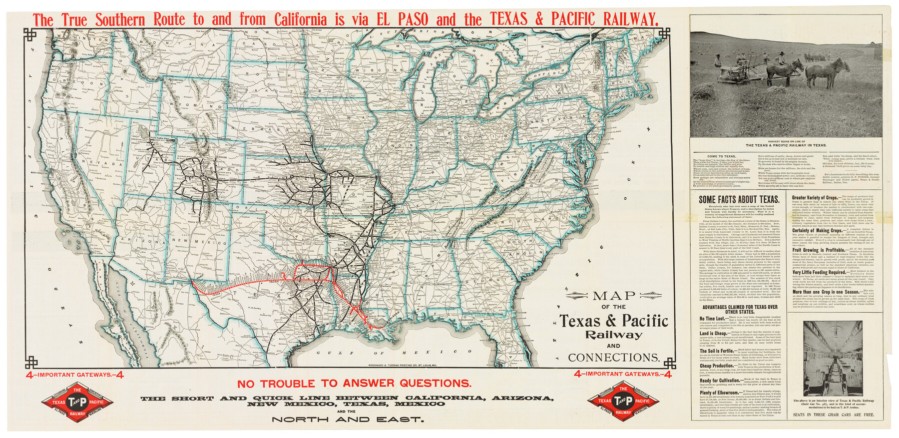
Map of the Texas & Pacific Railway and connections
The Short Line from Texas, Mexico and California to St. Louis, Memphis and all points north & east / The Direct Through Line from California, Colorado, and the West to Shreveport, New Orleans, Memphis and all points in the Southeast
-
Map/Doc
95770
-
Collection
Cobb Digital Map Collection
-
Object Dates
1911 (Creation Date)
-
Subjects
Railroads Texas and Pacific Railroad United States
-
Height x Width
18.1 x 37.1 inches
46.0 x 94.2 cm
-
Medium
digital image
-
Comments
Courtesy of John & Diana Cobb.
To view timetables printed on verso, click "Download PDF" link above.
Part of: Cobb Digital Map Collection
Map of Texas with population and location of principal towns and cities according to latest reliable statistics

Print $20.00
- Digital $50.00
Map of Texas with population and location of principal towns and cities according to latest reliable statistics
1911
Size 19.4 x 21.5 inches
Map/Doc 95875
Panhandle of Texas

Print $20.00
- Digital $50.00
Panhandle of Texas
1907
Size 11.4 x 14.4 inches
Map/Doc 95889
Texas and Northern Mexico

Print $20.00
- Digital $50.00
Texas and Northern Mexico
1925
Size 21.0 x 28.3 inches
Map/Doc 95900

Through Storyland to Sunset Seas

Through Storyland to Sunset Seas
1895
Size 8.9 x 6.7 inches
Map/Doc 96606
Corpus Christi, Where Texas Meets the Sea

Corpus Christi, Where Texas Meets the Sea
1927
Size 9.6 x 4.3 inches
Map/Doc 97064
[Map of Texas]
![95882, [Map of Texas], Cobb Digital Map Collection - 1](https://historictexasmaps.com/wmedia_w700/maps/95882.tif.jpg)
Print $20.00
- Digital $50.00
[Map of Texas]
1908
Size 18.5 x 18.7 inches
Map/Doc 95882
Wright's Special Train between Kansas City and the Panhandle Country

Wright's Special Train between Kansas City and the Panhandle Country
1906
Map/Doc 96752
The Rand McNally New Commercial Atlas Map of Texas

Print $20.00
- Digital $50.00
The Rand McNally New Commercial Atlas Map of Texas
1915
Size 28.5 x 40.3 inches
Map/Doc 95862
Greater Texas and the Coast Country - The Winter Garden

Greater Texas and the Coast Country - The Winter Garden
1911
Size 9.4 x 4.5 inches
Map/Doc 97057
Map of Texas with population and location of principal towns and cities according to latest reliable statistics

Print $20.00
- Digital $50.00
Map of Texas with population and location of principal towns and cities according to latest reliable statistics
1909
Size 18.3 x 20.2 inches
Map/Doc 95874
Corpus Christi, Where Texas Meets the Sea

Corpus Christi, Where Texas Meets the Sea
1928
Size 9.7 x 6.9 inches
Map/Doc 97065
You may also like
Kaufman County Sketch File 3

Print $20.00
- Digital $50.00
Kaufman County Sketch File 3
1857
Size 25.3 x 18.7 inches
Map/Doc 4856
Ellis County Sketch File 5

Print $4.00
- Digital $50.00
Ellis County Sketch File 5
Size 10.3 x 8.2 inches
Map/Doc 21834
Presidio County Boundary File 4

Print $8.00
- Digital $50.00
Presidio County Boundary File 4
Size 13.9 x 8.6 inches
Map/Doc 58083
Travis County Rolled Sketch 39

Print $148.00
- Digital $50.00
Travis County Rolled Sketch 39
Size 6.7 x 9.9 inches
Map/Doc 49130

Nolan County Working Sketch 9

Print $20.00
- Digital $50.00
Nolan County Working Sketch 9
1964
Size 25.0 x 36.8 inches
Map/Doc 71300
Reagan County Working Sketch 3

Print $40.00
- Digital $50.00
Reagan County Working Sketch 3
1923
Size 42.6 x 54.3 inches
Map/Doc 71843
Angelina County Working Sketch 21

Print $20.00
- Digital $50.00
Angelina County Working Sketch 21
1947
Size 35.7 x 35.8 inches
Map/Doc 67102
Trinity River, Potter Bridge Sheet/Kings Creek

Print $20.00
- Digital $50.00
Trinity River, Potter Bridge Sheet/Kings Creek
1928
Size 42.1 x 34.0 inches
Map/Doc 65220
Flight Mission No. CRK-3P, Frame 67, Refugio County

Print $20.00
- Digital $50.00
Flight Mission No. CRK-3P, Frame 67, Refugio County
1956
Size 18.5 x 22.3 inches
Map/Doc 86909
Comanche County Working Sketch 25

Print $20.00
- Digital $50.00
Comanche County Working Sketch 25
1976
Size 34.8 x 31.9 inches
Map/Doc 68159
Wharton County Sketch File A2

Print $32.00
- Digital $50.00
Wharton County Sketch File A2
1898
Size 22.1 x 15.7 inches
Map/Doc 12670