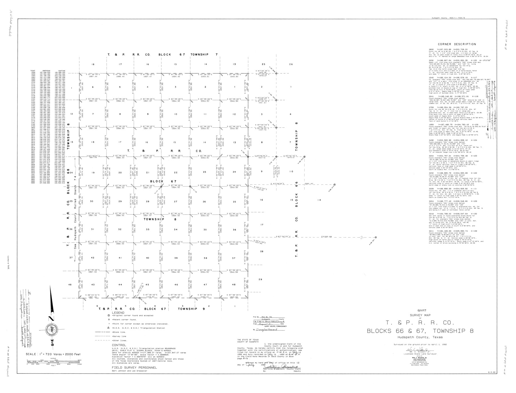
Hudspeth County Rolled Sketch 76
Survey map of T. & P. R.R. Co. Blocks 66 & 67, Township 8
-
Map/Doc
9239
-
Collection
General Map Collection
-
Object Dates
1992/4/1 (Creation Date)
1992/8/31 (File Date)
-
People and Organizations
Wm. C. Wilson, Jr. (Surveyor/Engineer)
Bart Johnson (Chainman/Field Personnel)
Lee Dresseler (Chainman/Field Personnel)
-
Counties
Hudspeth
-
Subjects
Surveying Rolled Sketch
-
Height x Width
49.5 x 37.7 inches
125.7 x 95.8 cm
-
Medium
mylar, print
-
Scale
1" = 720 varas
Part of: General Map Collection
Sutton County Rolled Sketch 40

Print $20.00
- Digital $50.00
Sutton County Rolled Sketch 40
1930
Size 25.9 x 28.3 inches
Map/Doc 7882

Baylor County Sketch File 27

Print $4.00
- Digital $50.00
Baylor County Sketch File 27
1895
Size 11.1 x 8.9 inches
Map/Doc 14226
Pecos County Working Sketch 45

Print $20.00
- Digital $50.00
Pecos County Working Sketch 45
1946
Size 20.8 x 26.7 inches
Map/Doc 71517
Map of the District of San Patricio and Nueces

Print $40.00
- Digital $50.00
Map of the District of San Patricio and Nueces
Size 93.8 x 38.4 inches
Map/Doc 93366
Plat showing proposed counties to be taken from Zapata, Starr & Hidalgo Counties

Print $20.00
- Digital $50.00
Plat showing proposed counties to be taken from Zapata, Starr & Hidalgo Counties
1911
Size 24.8 x 27.8 inches
Map/Doc 2660
Map of the European Settlements in Mexico or New Spain and the West Indies

Print $20.00
- Digital $50.00
Map of the European Settlements in Mexico or New Spain and the West Indies
1783
Size 14.1 x 21.1 inches
Map/Doc 93643
Andrews County Rolled Sketch 36

Print $20.00
- Digital $50.00
Andrews County Rolled Sketch 36
Size 22.1 x 18.6 inches
Map/Doc 77178
Ward County Working Sketch 23

Print $40.00
- Digital $50.00
Ward County Working Sketch 23
1953
Size 29.1 x 59.5 inches
Map/Doc 72329
Fort Bend County Sketch File 11a

Print $34.00
- Digital $50.00
Fort Bend County Sketch File 11a
1888
Size 14.3 x 9.1 inches
Map/Doc 22901
Webb County Working Sketch 17

Print $20.00
- Digital $50.00
Webb County Working Sketch 17
1923
Size 13.0 x 20.5 inches
Map/Doc 72382
Survey of Block L, University Lands, El Paso County, Texas

Print $40.00
- Digital $50.00
Survey of Block L, University Lands, El Paso County, Texas
1971
Size 43.4 x 71.6 inches
Map/Doc 2440
You may also like
Upton County Rolled Sketch 35

Print $20.00
- Digital $50.00
Upton County Rolled Sketch 35
1951
Size 37.3 x 19.2 inches
Map/Doc 8077
Intracoastal Waterway - Gibbstown to Port Arthur

Print $20.00
- Digital $50.00
Intracoastal Waterway - Gibbstown to Port Arthur
1960
Size 26.9 x 38.9 inches
Map/Doc 69831
Montgomery County Sketch File 11

Print $4.00
- Digital $50.00
Montgomery County Sketch File 11
1872
Size 6.7 x 7.9 inches
Map/Doc 31800
Duval County Sketch File 58

Print $20.00
- Digital $50.00
Duval County Sketch File 58
1940
Size 18.3 x 19.0 inches
Map/Doc 11406
Culberson County Rolled Sketch 11
Print $20.00
- Digital $50.00
Culberson County Rolled Sketch 11
1898
Size 25.6 x 45.9 inches
Map/Doc 5648
Orange County Sketch File 25

Print $20.00
- Digital $50.00
Orange County Sketch File 25
1914
Size 19.6 x 38.2 inches
Map/Doc 12122
Map of Jefferson County

Print $20.00
- Digital $50.00
Map of Jefferson County
1896
Size 25.3 x 21.6 inches
Map/Doc 3731
A New Map of ye North Parts of America according to the division thereof by the Articles of Peace in 1763

Print $20.00
A New Map of ye North Parts of America according to the division thereof by the Articles of Peace in 1763
1763
Size 8.5 x 11.3 inches
Map/Doc 95280
Cliffside Situated on Section 21, Block 9, Potter County, Texas

Print $2.00
- Digital $50.00
Cliffside Situated on Section 21, Block 9, Potter County, Texas
Size 6.1 x 11.5 inches
Map/Doc 92100
Nueces County NRC Article 33.136 Location Key Sheet

Print $20.00
- Digital $50.00
Nueces County NRC Article 33.136 Location Key Sheet
1975
Size 27.0 x 22.8 inches
Map/Doc 77033
Flight Mission No. DQO-6K, Frame 32, Galveston County

Print $20.00
- Digital $50.00
Flight Mission No. DQO-6K, Frame 32, Galveston County
1952
Size 18.7 x 22.4 inches
Map/Doc 85098
Map of the Western Part of Bexar District

Print $40.00
- Digital $50.00
Map of the Western Part of Bexar District
1849
Size 64.0 x 54.3 inches
Map/Doc 16944