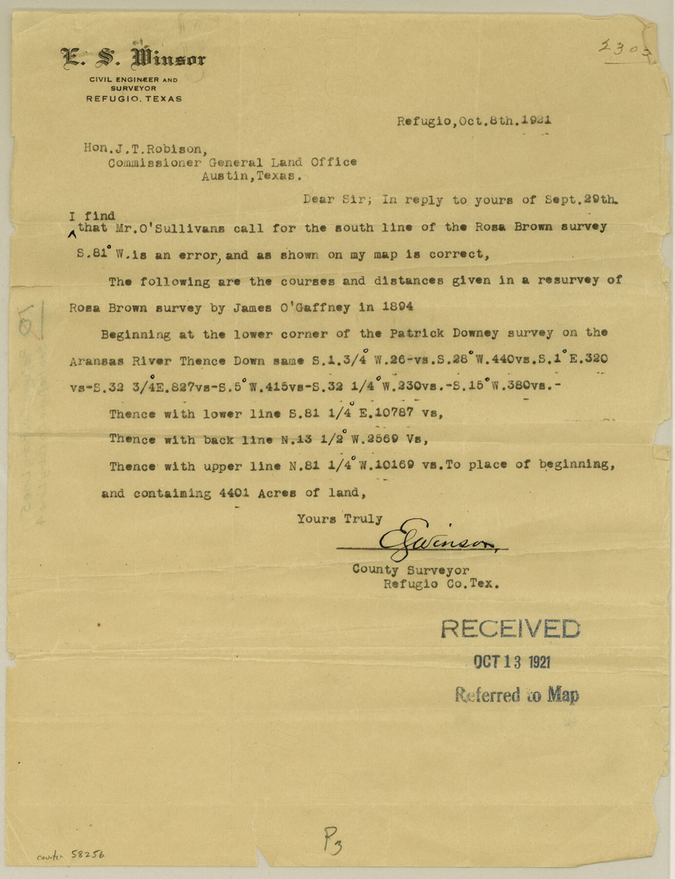
Refugio County Boundary File 5
[Letter regarding corrections of Refugio-Bee Boundary line]
-
Map/Doc
58256
-
Collection
General Map Collection
-
Counties
Refugio
-
Subjects
County Boundaries
-
Height x Width
11.2 x 8.6 inches
28.4 x 21.8 cm
Part of: General Map Collection
FT. W. & R. G. Ry. Right of Way Map, Winchell to Brady, McCulloch County, Texas

Print $20.00
- Digital $50.00
FT. W. & R. G. Ry. Right of Way Map, Winchell to Brady, McCulloch County, Texas
1918
Size 36.9 x 32.0 inches
Map/Doc 61416
Matagorda County NRC Article 33.136 Sketch 11

Print $42.00
- Digital $50.00
Matagorda County NRC Article 33.136 Sketch 11
Size 18.0 x 24.0 inches
Map/Doc 94465
[Surveys along the Liberty and Hardin County line]
![295, [Surveys along the Liberty and Hardin County line], General Map Collection](https://historictexasmaps.com/wmedia_w700/maps/295.tif.jpg)
Print $2.00
- Digital $50.00
[Surveys along the Liberty and Hardin County line]
1847
Size 13.5 x 7.7 inches
Map/Doc 295
Colorado County Sketch File 23

Print $4.00
- Digital $50.00
Colorado County Sketch File 23
1882
Size 8.8 x 8.3 inches
Map/Doc 18961
Presidio County Rolled Sketch 146

Print $20.00
- Digital $50.00
Presidio County Rolled Sketch 146
2018
Size 29.8 x 41.8 inches
Map/Doc 95821
Rains County Boundary File 1

Print $6.00
- Digital $50.00
Rains County Boundary File 1
Size 11.3 x 8.8 inches
Map/Doc 58090
Flight Mission No. CGI-3N, Frame 48, Cameron County

Print $20.00
- Digital $50.00
Flight Mission No. CGI-3N, Frame 48, Cameron County
1954
Size 18.7 x 22.2 inches
Map/Doc 84554

Topographical Map of the Rio Grande, Sheet No. 19

Print $20.00
- Digital $50.00
Topographical Map of the Rio Grande, Sheet No. 19
1912
Map/Doc 89543
Mineral Plats - El Paso to Ward Co. and River Beds

Mineral Plats - El Paso to Ward Co. and River Beds
Map/Doc 81746
Hutchinson County Rolled Sketch 40

Print $20.00
- Digital $50.00
Hutchinson County Rolled Sketch 40
1981
Size 26.1 x 37.5 inches
Map/Doc 6298
Crockett County Working Sketch 52

Print $20.00
- Digital $50.00
Crockett County Working Sketch 52
1941
Size 26.0 x 33.5 inches
Map/Doc 68385
You may also like
Brewster County Working Sketch 66

Print $20.00
- Digital $50.00
Brewster County Working Sketch 66
1958
Size 42.2 x 30.6 inches
Map/Doc 67667
Bee County Sketch File 4a

Print $4.00
- Digital $50.00
Bee County Sketch File 4a
Size 7.1 x 8.5 inches
Map/Doc 14270
Lipscomb County Boundary File 1

Print $16.00
- Digital $50.00
Lipscomb County Boundary File 1
Size 9.0 x 8.0 inches
Map/Doc 56307
Oldham County Boundary File 1c

Print $48.00
- Digital $50.00
Oldham County Boundary File 1c
Size 14.0 x 8.4 inches
Map/Doc 57753
Maps of Gulf Intracoastal Waterway, Texas - Sabine River to the Rio Grande and connecting waterways including ship channels

Print $20.00
- Digital $50.00
Maps of Gulf Intracoastal Waterway, Texas - Sabine River to the Rio Grande and connecting waterways including ship channels
1966
Size 14.5 x 22.2 inches
Map/Doc 61926
Dallas County Rolled Sketch 2

Print $40.00
- Digital $50.00
Dallas County Rolled Sketch 2
1950
Size 36.9 x 51.0 inches
Map/Doc 8766
Bosque County Sketch File 33

Print $40.00
- Digital $50.00
Bosque County Sketch File 33
Size 16.9 x 33.9 inches
Map/Doc 10939
Coleman County Sketch File 25

Print $40.00
- Digital $50.00
Coleman County Sketch File 25
1872
Size 12.5 x 15.8 inches
Map/Doc 18710
Young County Working Sketch 20

Print $20.00
- Digital $50.00
Young County Working Sketch 20
1961
Size 25.5 x 23.2 inches
Map/Doc 62043
[Hutchinson County, Blocks R, XO, M-22, M-25]
![91152, [Hutchinson County, Blocks R, XO, M-22, M-25], Twichell Survey Records](https://historictexasmaps.com/wmedia_w700/maps/91152-1.tif.jpg)
Print $20.00
- Digital $50.00
[Hutchinson County, Blocks R, XO, M-22, M-25]
Size 28.5 x 25.9 inches
Map/Doc 91152
Flight Mission No. BRE-2P, Frame 77, Nueces County

Print $20.00
- Digital $50.00
Flight Mission No. BRE-2P, Frame 77, Nueces County
1956
Size 18.4 x 22.2 inches
Map/Doc 86772
Jasper County Sketch File 12b

Print $4.00
- Digital $50.00
Jasper County Sketch File 12b
Size 12.7 x 7.6 inches
Map/Doc 27802