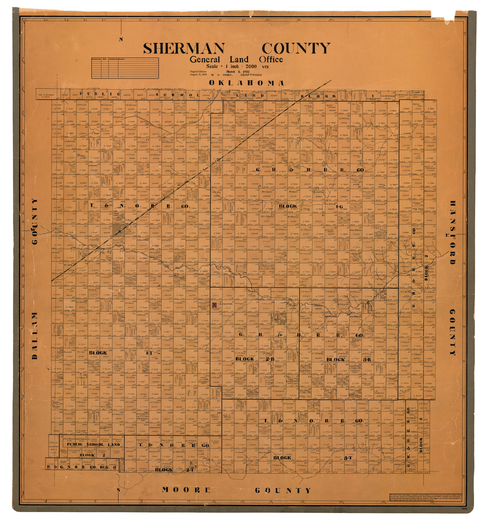
Sherman County
General Land Office Official County Map
-
Map/Doc
95640
-
Collection
General Map Collection
-
Object Dates
2019/8/31 (Revision Date)
1932/3/8 (Creation Date)
-
People and Organizations
Cheyenne Betancourt (Draftsman)
W.S. Vines (Draftsman)
-
Counties
Sherman
-
Subjects
County OCM
-
Height x Width
39.8 x 37.3 inches
101.1 x 94.7 cm
-
Medium
digital image
-
Scale
1" = 2000 varas
Part of: General Map Collection
Dimmit County Rolled Sketch 19

Print $20.00
- Digital $50.00
Dimmit County Rolled Sketch 19
1990
Size 45.4 x 41.7 inches
Map/Doc 8799
Cooke County Rolled Sketch 6

Print $20.00
- Digital $50.00
Cooke County Rolled Sketch 6
1981
Size 19.7 x 25.1 inches
Map/Doc 5564
Jasper County Working Sketch 35

Print $20.00
- Digital $50.00
Jasper County Working Sketch 35
2008
Size 28.5 x 40.0 inches
Map/Doc 88733
Harrison County Working Sketch 18

Print $20.00
- Digital $50.00
Harrison County Working Sketch 18
1976
Size 37.0 x 40.1 inches
Map/Doc 66038
Presidio County Working Sketch 36

Print $20.00
- Digital $50.00
Presidio County Working Sketch 36
1947
Size 27.9 x 40.7 inches
Map/Doc 71713
Goliad County Sketch File 15

Print $4.00
- Digital $50.00
Goliad County Sketch File 15
1879
Size 8.1 x 14.9 inches
Map/Doc 24245
Pecos County Boundary File 1a

Print $12.00
- Digital $50.00
Pecos County Boundary File 1a
Size 12.6 x 8.3 inches
Map/Doc 57855
Flight Mission No. BQR-9K, Frame 46, Brazoria County

Print $20.00
- Digital $50.00
Flight Mission No. BQR-9K, Frame 46, Brazoria County
1952
Size 18.7 x 22.3 inches
Map/Doc 84050
Flight Mission No. BRE-1P, Frame 116, Nueces County

Print $20.00
- Digital $50.00
Flight Mission No. BRE-1P, Frame 116, Nueces County
1956
Size 18.6 x 22.5 inches
Map/Doc 86682
Andrews County Rolled Sketch 20

Print $20.00
- Digital $50.00
Andrews County Rolled Sketch 20
Size 31.6 x 40.0 inches
Map/Doc 8395
Wharton County Rolled Sketch 11

Print $20.00
- Digital $50.00
Wharton County Rolled Sketch 11
Size 27.3 x 37.2 inches
Map/Doc 8235
Castro County Sketch File 4k

Print $4.00
- Digital $50.00
Castro County Sketch File 4k
Size 13.6 x 8.6 inches
Map/Doc 17485
You may also like
Flight Mission No. BRA-3M, Frame 191, Jefferson County

Print $20.00
- Digital $50.00
Flight Mission No. BRA-3M, Frame 191, Jefferson County
1953
Size 18.6 x 22.3 inches
Map/Doc 85406
Hudspeth County Sketch File 29

Print $20.00
- Digital $50.00
Hudspeth County Sketch File 29
1918
Size 22.3 x 21.4 inches
Map/Doc 11804
Trinity River, Daugherty Lake Sheet/East Fork of Trinity River

Print $20.00
- Digital $50.00
Trinity River, Daugherty Lake Sheet/East Fork of Trinity River
1920
Size 41.9 x 30.1 inches
Map/Doc 65191
Kent County Rolled Sketch 6

Print $20.00
- Digital $50.00
Kent County Rolled Sketch 6
Size 39.0 x 36.5 inches
Map/Doc 6476
Van Zandt County Working Sketch 6a

Print $40.00
- Digital $50.00
Van Zandt County Working Sketch 6a
1941
Size 57.2 x 25.7 inches
Map/Doc 69762
Flight Mission No. CRC-3R, Frame 51, Chambers County

Print $20.00
- Digital $50.00
Flight Mission No. CRC-3R, Frame 51, Chambers County
1956
Size 18.7 x 22.4 inches
Map/Doc 84824
![94191, California [Verso], General Map Collection](https://historictexasmaps.com/wmedia_w700/maps/94191.tif.jpg)
Travis County Working Sketch 40

Print $20.00
- Digital $50.00
Travis County Working Sketch 40
1974
Size 31.7 x 32.1 inches
Map/Doc 69424
Flight Mission No. BRE-2P, Frame 67, Nueces County

Print $20.00
- Digital $50.00
Flight Mission No. BRE-2P, Frame 67, Nueces County
1956
Size 18.5 x 22.3 inches
Map/Doc 86762
Zapata County Working Sketch 7

Print $40.00
- Digital $50.00
Zapata County Working Sketch 7
1946
Size 42.8 x 53.4 inches
Map/Doc 62058
Madison County Working Sketch 2

Print $20.00
- Digital $50.00
Madison County Working Sketch 2
1933
Size 23.4 x 25.5 inches
Map/Doc 70764
Irion County Working Sketch 5

Print $20.00
- Digital $50.00
Irion County Working Sketch 5
1929
Size 24.3 x 17.9 inches
Map/Doc 66414