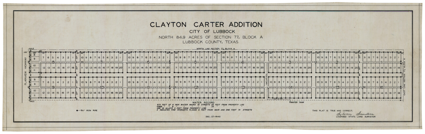
Clayton Carter Addition, North 84.9 Acres of Section 77, Block A
-
Map/Doc
92767
-
Collection
Twichell Survey Records
-
Object Dates
12/27/1945 (Creation Date)
-
People and Organizations
Sylvan Sanders (Surveyor/Engineer)
-
Counties
Lubbock
-
Height x Width
30.1 x 9.6 inches
76.5 x 24.4 cm
Part of: Twichell Survey Records
Map Showing the Location of Murray Farms

Print $20.00
- Digital $50.00
Map Showing the Location of Murray Farms
Size 13.6 x 17.7 inches
Map/Doc 92832
Working Sketch in Bastrop County

Print $20.00
- Digital $50.00
Working Sketch in Bastrop County
1923
Size 32.6 x 37.9 inches
Map/Doc 90147
W.D. Twichell's and R.S. Hunnicutt's Resurvey in Oldham County, Texas May to October 1915

Print $20.00
- Digital $50.00
W.D. Twichell's and R.S. Hunnicutt's Resurvey in Oldham County, Texas May to October 1915
1915
Size 47.6 x 38.3 inches
Map/Doc 89970
[Sketch of Leagues 458, 459, 474, 475, 480 and 481]
![91547, [Sketch of Leagues 458, 459, 474, 475, 480 and 481], Twichell Survey Records](https://historictexasmaps.com/wmedia_w700/maps/91547-1.tif.jpg)
Print $2.00
- Digital $50.00
[Sketch of Leagues 458, 459, 474, 475, 480 and 481]
Size 5.2 x 8.3 inches
Map/Doc 91547
![91541, [Capitol Lands], Twichell Survey Records](https://historictexasmaps.com/wmedia_w700/maps/91541-2.tif.jpg)
Plat in Pecos County, Texas

Print $20.00
- Digital $50.00
Plat in Pecos County, Texas
Size 38.7 x 37.5 inches
Map/Doc 89834
[H. & G. N. RR. Co. Block 1]
![90889, [H. & G. N. RR. Co. Block 1], Twichell Survey Records](https://historictexasmaps.com/wmedia_w700/maps/90889-1.tif.jpg)
Print $20.00
- Digital $50.00
[H. & G. N. RR. Co. Block 1]
Size 16.5 x 27.9 inches
Map/Doc 90889
[Northwest 1/4 of County]
![90824, [Northwest 1/4 of County], Twichell Survey Records](https://historictexasmaps.com/wmedia_w700/maps/90824-2.tif.jpg)
Print $20.00
- Digital $50.00
[Northwest 1/4 of County]
Size 19.1 x 23.3 inches
Map/Doc 90824
[Letter from T. F. Pinckney to W. D. Twichell accompanying sketch showing Blocks 14, 341, and G5]
![93111, [Letter from T. F. Pinckney to W. D. Twichell accompanying sketch showing Blocks 14, 341, and G5], Twichell Survey Records](https://historictexasmaps.com/wmedia_w700/maps/93111-1.tif.jpg)
Print $2.00
- Digital $50.00
[Letter from T. F. Pinckney to W. D. Twichell accompanying sketch showing Blocks 14, 341, and G5]
Size 15.1 x 7.9 inches
Map/Doc 93111
Glasscock Public Roads

Print $20.00
- Digital $50.00
Glasscock Public Roads
Size 38.3 x 36.8 inches
Map/Doc 89944
[Sketch in Southeast Part of County around J. H. Gibson Sections 1 and 2]
![91906, [Sketch in Southeast Part of County around J. H. Gibson Sections 1 and 2], Twichell Survey Records](https://historictexasmaps.com/wmedia_w700/maps/91906-1.tif.jpg)
Print $2.00
- Digital $50.00
[Sketch in Southeast Part of County around J. H. Gibson Sections 1 and 2]
Size 14.2 x 7.3 inches
Map/Doc 91906
Willie Winn Tract

Print $20.00
- Digital $50.00
Willie Winn Tract
1903
Size 13.2 x 14.1 inches
Map/Doc 92286
You may also like
The Mexican Municipality of Jefferson. Defined, December 9, 1835

Print $20.00
The Mexican Municipality of Jefferson. Defined, December 9, 1835
2020
Size 15.5 x 21.7 inches
Map/Doc 96024
Map of the Lands Surveyed by the Memphis, El Paso & Pacific R.R. Company

Print $20.00
- Digital $50.00
Map of the Lands Surveyed by the Memphis, El Paso & Pacific R.R. Company
1860
Size 18.6 x 19.0 inches
Map/Doc 4846
Flight Mission No. DCL-7C, Frame 56, Kenedy County

Print $20.00
- Digital $50.00
Flight Mission No. DCL-7C, Frame 56, Kenedy County
1943
Size 15.4 x 15.2 inches
Map/Doc 86044
Hemphill County Working Sketch 22

Print $40.00
- Digital $50.00
Hemphill County Working Sketch 22
1973
Size 76.0 x 30.2 inches
Map/Doc 66117
Flight Mission No. DQO-3K, Frame 38, Galveston County

Print $20.00
- Digital $50.00
Flight Mission No. DQO-3K, Frame 38, Galveston County
1952
Size 18.7 x 22.3 inches
Map/Doc 85079
McMullen County Working Sketch 40

Print $40.00
- Digital $50.00
McMullen County Working Sketch 40
1975
Size 48.3 x 34.8 inches
Map/Doc 70741
The Texas and Pacific Ry. Co., Station Map, Loraine, Texas

Print $20.00
- Digital $50.00
The Texas and Pacific Ry. Co., Station Map, Loraine, Texas
Size 11.6 x 18.6 inches
Map/Doc 64683
Flight Mission No. CRK-5P, Frame 158, Refugio County

Print $20.00
- Digital $50.00
Flight Mission No. CRK-5P, Frame 158, Refugio County
1956
Size 18.6 x 22.5 inches
Map/Doc 86939
Stonewall County Boundary File 3a

Print $68.00
- Digital $50.00
Stonewall County Boundary File 3a
Size 14.4 x 9.0 inches
Map/Doc 58970
Origins of Imports and Destination of Exports at Houston, Tex., during 1921

Print $20.00
- Digital $50.00
Origins of Imports and Destination of Exports at Houston, Tex., during 1921
1921
Size 14.2 x 23.1 inches
Map/Doc 97171
Map of Harris County

Print $40.00
- Digital $50.00
Map of Harris County
1896
Size 50.0 x 68.7 inches
Map/Doc 4675
Kendall County Working Sketch 22

Print $20.00
- Digital $50.00
Kendall County Working Sketch 22
1971
Size 41.6 x 34.7 inches
Map/Doc 66694