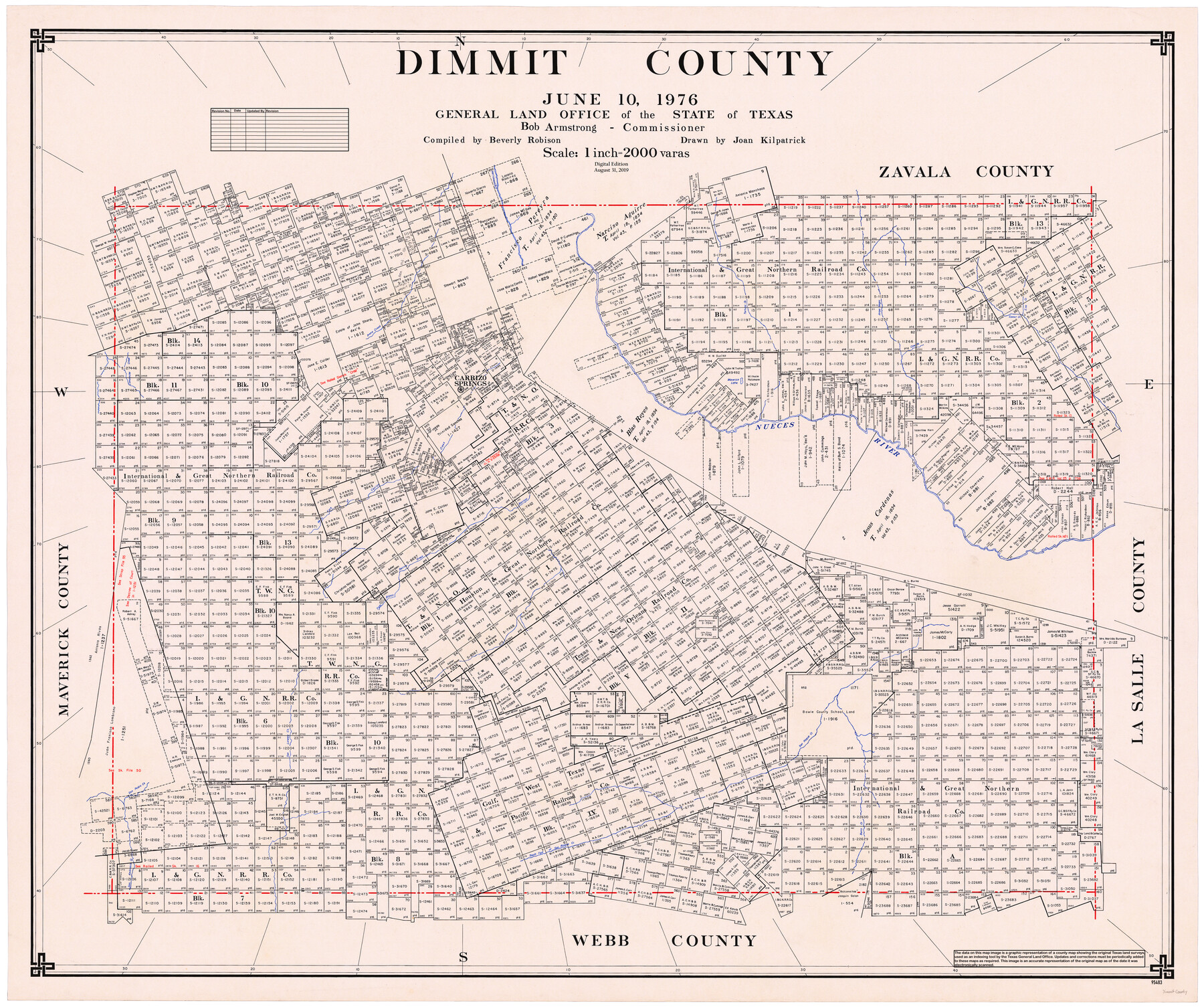
Dimmit County
General Land Office Official County Map
-
Map/Doc
95483
-
Collection
General Map Collection
-
Object Dates
2019/8/31 (Revision Date)
1976/6/10 (Creation Date)
-
People and Organizations
Cheyenne Betancourt (Draftsman)
Joan Kilpatrick (Draftsman)
Beverly Robison (Compiler)
Bob Armstrong (GLO Commissioner)
-
Counties
Dimmit
-
Subjects
County OCM
-
Height x Width
43.2 x 51.7 inches
109.7 x 131.3 cm
-
Medium
digital image
-
Scale
1" = 2000 varas
Part of: General Map Collection
Real County Working Sketch 44

Print $20.00
- Digital $50.00
Real County Working Sketch 44
1953
Size 28.3 x 24.3 inches
Map/Doc 71936
Duval County Working Sketch 55

Print $20.00
- Digital $50.00
Duval County Working Sketch 55
1936
Size 25.7 x 21.6 inches
Map/Doc 68779
Midland County Sketch File M

Print $20.00
- Digital $50.00
Midland County Sketch File M
Size 18.5 x 14.9 inches
Map/Doc 12090
Sterling County Working Sketch 1

Print $20.00
- Digital $50.00
Sterling County Working Sketch 1
1926
Size 30.3 x 29.6 inches
Map/Doc 63983
A General Map of the Middle British Colonies, in America. containing Virginia, Maryland, the Delaware Counties, Pennsylvania and New Jersey. With the addition of New York and of the Greatest Part of New England

Print $20.00
- Digital $50.00
A General Map of the Middle British Colonies, in America. containing Virginia, Maryland, the Delaware Counties, Pennsylvania and New Jersey. With the addition of New York and of the Greatest Part of New England
1776
Size 21.6 x 27.2 inches
Map/Doc 97402
Foard County Sketch File 34

Print $20.00
- Digital $50.00
Foard County Sketch File 34
1889
Size 29.1 x 24.9 inches
Map/Doc 11497
Delta County Sketch File 6

Print $20.00
- Digital $50.00
Delta County Sketch File 6
Size 18.3 x 22.4 inches
Map/Doc 11310
Reagan County

Print $40.00
- Digital $50.00
Reagan County
1940
Size 50.8 x 41.2 inches
Map/Doc 95621
Maps of Gulf Intracoastal Waterway, Texas - Sabine River to the Rio Grande and connecting waterways including ship channels

Print $20.00
- Digital $50.00
Maps of Gulf Intracoastal Waterway, Texas - Sabine River to the Rio Grande and connecting waterways including ship channels
1966
Size 14.5 x 22.3 inches
Map/Doc 61921

Part of Laguna Madre in Willacy and Cameron Counties, showing Subdivision for Mineral Development

Print $20.00
- Digital $50.00
Part of Laguna Madre in Willacy and Cameron Counties, showing Subdivision for Mineral Development
1950
Size 45.1 x 36.8 inches
Map/Doc 1925
Nueces County NRC Article 33.136 Sketch 20

Print $36.00
- Digital $50.00
Nueces County NRC Article 33.136 Sketch 20
2021
Map/Doc 96887
You may also like
Pecos County Rolled Sketch 75

Print $20.00
- Digital $50.00
Pecos County Rolled Sketch 75
Size 18.8 x 37.5 inches
Map/Doc 7237
Upton County Working Sketch 43

Print $40.00
- Digital $50.00
Upton County Working Sketch 43
1962
Size 56.8 x 42.7 inches
Map/Doc 69539
Medina County Working Sketch 19

Print $20.00
- Digital $50.00
Medina County Working Sketch 19
1980
Size 19.4 x 29.1 inches
Map/Doc 70934
Upton County Rolled Sketch 14

Print $20.00
- Digital $50.00
Upton County Rolled Sketch 14
Size 43.2 x 32.0 inches
Map/Doc 10038
Mason County Working Sketch 9

Print $20.00
- Digital $50.00
Mason County Working Sketch 9
1949
Size 34.4 x 29.4 inches
Map/Doc 70845
Comal County Working Sketch Graphic Index

Print $20.00
- Digital $50.00
Comal County Working Sketch Graphic Index
1947
Size 41.8 x 35.9 inches
Map/Doc 76501
[Galveston, Harrisburg & San Antonio through El Paso County]
![64003, [Galveston, Harrisburg & San Antonio through El Paso County], General Map Collection](https://historictexasmaps.com/wmedia_w700/maps/64003.tif.jpg)
Print $20.00
- Digital $50.00
[Galveston, Harrisburg & San Antonio through El Paso County]
1907
Size 13.7 x 33.9 inches
Map/Doc 64003
General Highway Map, Crockett County, Texas

Print $20.00
General Highway Map, Crockett County, Texas
1940
Size 18.3 x 25.1 inches
Map/Doc 79062
Scurry County Working Sketch 8

Print $40.00
- Digital $50.00
Scurry County Working Sketch 8
1980
Size 34.5 x 49.5 inches
Map/Doc 63837
General Highway Map, Maverick County, Texas

Print $20.00
General Highway Map, Maverick County, Texas
1961
Size 18.2 x 24.6 inches
Map/Doc 79587
Wichita County

Print $20.00
- Digital $50.00
Wichita County
1971
Size 39.1 x 40.8 inches
Map/Doc 95673
Calhoun County Rolled Sketch 24

Print $40.00
- Digital $50.00
Calhoun County Rolled Sketch 24
1962
Size 26.0 x 58.3 inches
Map/Doc 5373