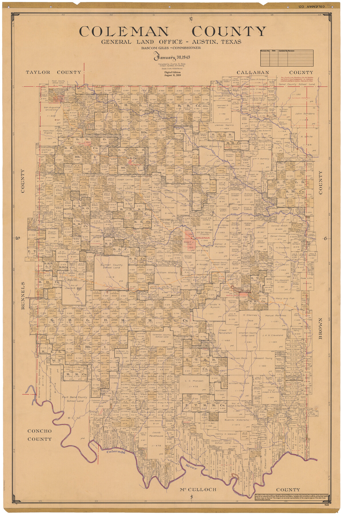
Coleman County
General Land Office Official County Map
-
Map/Doc
95458
-
Collection
General Map Collection
-
Object Dates
2019/8/31 (Revision Date)
1945/1/30 (Creation Date)
-
People and Organizations
Cheyenne Betancourt (Draftsman)
Eltea Armstrong (Draftsman)
Curtis R. Hale (Compiler)
Bascom Giles (GLO Commissioner)
-
Counties
Coleman
-
Subjects
County OCM
-
Height x Width
55.7 x 37.1 inches
141.5 x 94.2 cm
-
Medium
digital image
-
Scale
1" = 2000 varas
Part of: General Map Collection
Reeves County

Print $40.00
- Digital $50.00
Reeves County
1945
Size 49.4 x 40.8 inches
Map/Doc 95624
Waller County Sketch File 2

Print $52.00
- Digital $50.00
Waller County Sketch File 2
Size 13.3 x 9.0 inches
Map/Doc 39570
Anderson County

Print $20.00
- Digital $50.00
Anderson County
1871
Size 18.3 x 20.8 inches
Map/Doc 776
Briscoe County

Print $20.00
- Digital $50.00
Briscoe County
1930
Size 42.0 x 35.8 inches
Map/Doc 73090
El Paso County Sketch File 26

Print $20.00
- Digital $50.00
El Paso County Sketch File 26
Size 24.8 x 21.9 inches
Map/Doc 11457
[Sketch for Mineral Application 26501 - Sabine River, T. A. Oldhausen]
![2837, [Sketch for Mineral Application 26501 - Sabine River, T. A. Oldhausen], General Map Collection](https://historictexasmaps.com/wmedia_w700/maps/2837.tif.jpg)
Print $20.00
- Digital $50.00
[Sketch for Mineral Application 26501 - Sabine River, T. A. Oldhausen]
1931
Size 24.1 x 36.0 inches
Map/Doc 2837
Cameron County Rolled Sketch 17

Print $20.00
- Digital $50.00
Cameron County Rolled Sketch 17
1937
Size 47.0 x 34.0 inches
Map/Doc 61788

Dickens County Sketch File 35

Print $10.00
- Digital $50.00
Dickens County Sketch File 35
1954
Size 11.2 x 8.9 inches
Map/Doc 64791
Jefferson County Sketch File 13

Print $6.00
- Digital $50.00
Jefferson County Sketch File 13
Size 14.9 x 9.3 inches
Map/Doc 28147
Kimble County Working Sketch 80

Print $20.00
- Digital $50.00
Kimble County Working Sketch 80
1971
Size 32.3 x 24.3 inches
Map/Doc 70148
New Map of Texas prepared and published for the Bureau of Immigration of the State of Texas

Print $20.00
- Digital $50.00
New Map of Texas prepared and published for the Bureau of Immigration of the State of Texas
1875
Size 15.8 x 18.3 inches
Map/Doc 93626
You may also like
Hays County Sketch File 2

Print $4.00
- Digital $50.00
Hays County Sketch File 2
1846
Size 6.3 x 8.1 inches
Map/Doc 26200
Palo Pinto County Working Sketch 24

Print $20.00
- Digital $50.00
Palo Pinto County Working Sketch 24
1990
Map/Doc 71407
Moore County Rolled Sketch 13
Print $20.00
- Digital $50.00
Moore County Rolled Sketch 13
1920
Size 25.8 x 33.3 inches
Map/Doc 6829
Lubbock County Sketch File 15

Print $6.00
- Digital $50.00
Lubbock County Sketch File 15
1902
Size 11.2 x 8.8 inches
Map/Doc 30440
Bailey County Rolled Sketch R and C

Print $51.00
- Digital $50.00
Bailey County Rolled Sketch R and C
1913
Size 10.1 x 16.0 inches
Map/Doc 42350
Current Miscellaneous File 49

Print $4.00
- Digital $50.00
Current Miscellaneous File 49
Size 11.2 x 8.8 inches
Map/Doc 74012
Flight Mission No. DCL-7C, Frame 144, Kenedy County

Print $20.00
- Digital $50.00
Flight Mission No. DCL-7C, Frame 144, Kenedy County
1943
Size 18.6 x 22.5 inches
Map/Doc 86101

Map of the World on a Globular Projection to illustrate Olney's school geography

Print $20.00
- Digital $50.00
Map of the World on a Globular Projection to illustrate Olney's school geography
1844
Size 12.1 x 19.0 inches
Map/Doc 93535
Map of section no. 9 of a survey of Padre Island made for the Office of the Attorney General of the State of Texas

Print $40.00
- Digital $50.00
Map of section no. 9 of a survey of Padre Island made for the Office of the Attorney General of the State of Texas
1941
Size 58.3 x 42.5 inches
Map/Doc 2265
Nueces County Rolled Sketch 63

Print $20.00
- Digital $50.00
Nueces County Rolled Sketch 63
1979
Size 25.5 x 38.1 inches
Map/Doc 6909
Dr. S. C. Arnett Farm Part Section 5, Block E2

Print $20.00
- Digital $50.00
Dr. S. C. Arnett Farm Part Section 5, Block E2
Size 12.7 x 15.8 inches
Map/Doc 92296