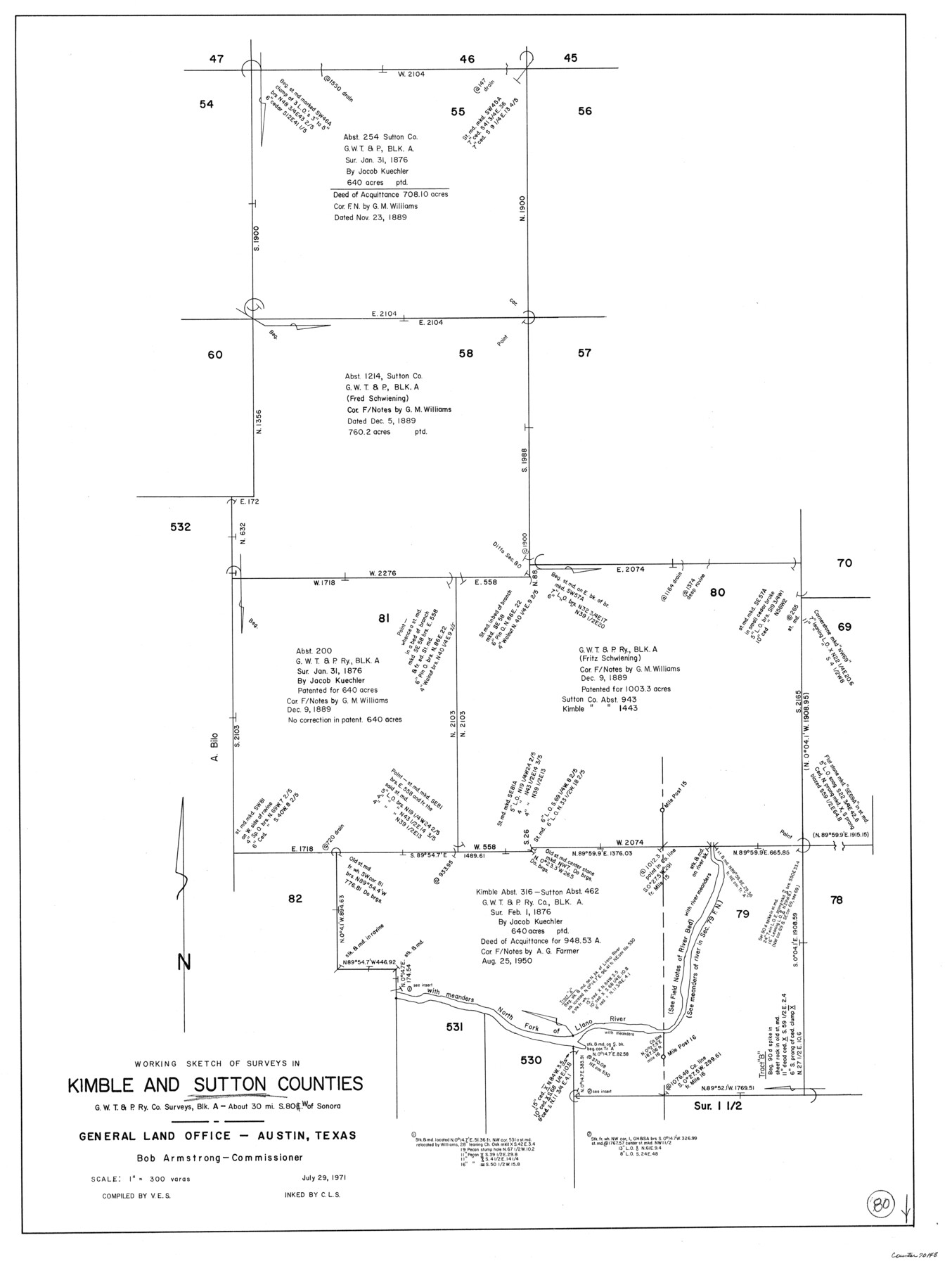
Kimble County Working Sketch 80
-
Map/Doc
70148
-
Collection
General Map Collection
-
Object Dates
7/29/1971 (Creation Date)
-
People and Organizations
Victor E. Sterzing (Compiler)
Crockett L. Slover (Inker)
-
Counties
Kimble Sutton
-
Subjects
Surveying Working Sketch
-
Height x Width
32.3 x 24.3 inches
82.0 x 61.7 cm
-
Scale
1" = 300 varas
Part of: General Map Collection
Preliminary Chart No. 31 of the Sea Coast of the United States from Galveston Bay to Matagorda Bay, Texas

Print $20.00
- Digital $50.00
Preliminary Chart No. 31 of the Sea Coast of the United States from Galveston Bay to Matagorda Bay, Texas
1857
Size 23.3 x 28.1 inches
Map/Doc 69950
Archer County Boundary File 6

Print $62.00
- Digital $50.00
Archer County Boundary File 6
Size 22.5 x 6.1 inches
Map/Doc 50113
West Part Presidio Co.

Print $20.00
- Digital $50.00
West Part Presidio Co.
1974
Size 43.2 x 34.3 inches
Map/Doc 95618
Jefferson County

Print $20.00
- Digital $50.00
Jefferson County
1882
Size 22.8 x 20.0 inches
Map/Doc 3730
Flight Mission No. CRC-2R, Frame 190, Chambers County

Print $20.00
- Digital $50.00
Flight Mission No. CRC-2R, Frame 190, Chambers County
1956
Size 18.8 x 22.4 inches
Map/Doc 84768
Flight Mission No. CUG-3P, Frame 189, Kleberg County

Print $20.00
- Digital $50.00
Flight Mission No. CUG-3P, Frame 189, Kleberg County
1956
Size 18.6 x 22.2 inches
Map/Doc 86293
Angelina County

Print $40.00
- Digital $50.00
Angelina County
1945
Size 39.0 x 48.4 inches
Map/Doc 73068
Wharton County Rolled Sketch 8

Print $20.00
- Digital $50.00
Wharton County Rolled Sketch 8
Size 24.4 x 39.2 inches
Map/Doc 8232
Limestone Co.

Print $40.00
- Digital $50.00
Limestone Co.
1971
Size 49.9 x 34.5 inches
Map/Doc 95571
Hudspeth County Rolled Sketch 43A

Print $3.00
- Digital $50.00
Hudspeth County Rolled Sketch 43A
1958
Size 10.7 x 8.8 inches
Map/Doc 6252
King County Boundary File 5

Print $12.00
- Digital $50.00
King County Boundary File 5
Size 14.2 x 8.8 inches
Map/Doc 64916
Brewster County Rolled Sketch 28

Print $20.00
- Digital $50.00
Brewster County Rolled Sketch 28
1910
Size 25.6 x 29.4 inches
Map/Doc 5215
You may also like
Bee County Boundary File 4

Print $22.00
- Digital $50.00
Bee County Boundary File 4
Size 12.9 x 8.1 inches
Map/Doc 50441
Van Zandt County Sketch File 41

Print $13.00
- Digital $50.00
Van Zandt County Sketch File 41
Size 12.8 x 8.5 inches
Map/Doc 39489
Nueces County Rolled Sketch 126

Print $20.00
- Digital $50.00
Nueces County Rolled Sketch 126
1998
Size 24.5 x 36.8 inches
Map/Doc 7161
Dallam County Working Sketch 4

Print $20.00
- Digital $50.00
Dallam County Working Sketch 4
1974
Size 31.2 x 32.0 inches
Map/Doc 68589
Plat Showing the Development of Texas Counties from the Original Land Districts

Print $40.00
- Digital $50.00
Plat Showing the Development of Texas Counties from the Original Land Districts
Size 49.1 x 28.1 inches
Map/Doc 75932
Crane County Rolled Sketch 13

Print $20.00
- Digital $50.00
Crane County Rolled Sketch 13
1940
Size 42.4 x 23.3 inches
Map/Doc 5575
Military Reconnaissance [showing forts along Rio Grande near Matamoros]
![72909, Military Reconnaissance [showing forts along Rio Grande near Matamoros], General Map Collection](https://historictexasmaps.com/wmedia_w700/maps/72909.tif.jpg)
Print $20.00
- Digital $50.00
Military Reconnaissance [showing forts along Rio Grande near Matamoros]
1846
Size 18.2 x 26.3 inches
Map/Doc 72909
Flight Mission No. DAG-26K, Frame 82, Matagorda County

Print $20.00
- Digital $50.00
Flight Mission No. DAG-26K, Frame 82, Matagorda County
1953
Size 18.4 x 19.1 inches
Map/Doc 86587
[Portions of Blocks 20, 24, S, and the West Lone of Wilson County School Land]
![91326, [Portions of Blocks 20, 24, S, and the West Lone of Wilson County School Land], Twichell Survey Records](https://historictexasmaps.com/wmedia_w700/maps/91326-1.tif.jpg)
Print $20.00
- Digital $50.00
[Portions of Blocks 20, 24, S, and the West Lone of Wilson County School Land]
1910
Size 27.9 x 15.7 inches
Map/Doc 91326
Flight Mission No. CON-2R, Frame 55, Stonewall County

Print $20.00
- Digital $50.00
Flight Mission No. CON-2R, Frame 55, Stonewall County
1957
Size 18.3 x 22.0 inches
Map/Doc 86987
