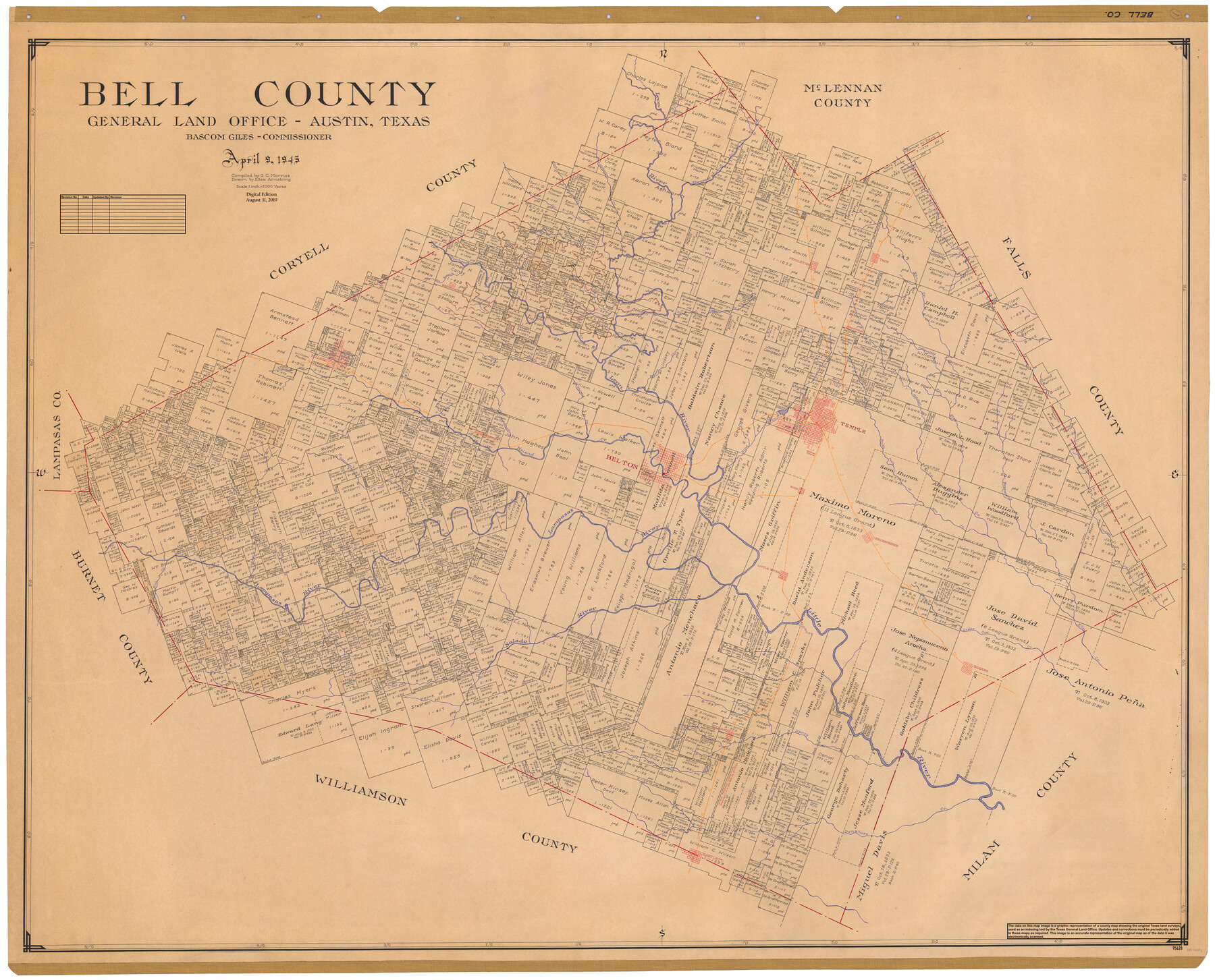
Bell County
General Land Office Official County Map
-
Map/Doc
95428
-
Collection
General Map Collection
-
Object Dates
2019/8/31 (Revision Date)
1945/4/9 (Creation Date)
-
People and Organizations
Cheyenne Betancourt (Draftsman)
Eltea Armstrong (Draftsman)
G.C. Morriss (Compiler)
Bascom Giles (GLO Commissioner)
-
Counties
Bell
-
Subjects
County OCM
-
Height x Width
43.8 x 54.3 inches
111.3 x 137.9 cm
-
Medium
digital image
-
Scale
1" = 2000 varas
Part of: General Map Collection
Harris County Rolled Sketch 93

Print $20.00
- Digital $50.00
Harris County Rolled Sketch 93
1983
Size 45.0 x 40.2 inches
Map/Doc 9142
United States - Gulf Coast - From Latitude 26° 33' to the Rio Grande Texas

Print $20.00
- Digital $50.00
United States - Gulf Coast - From Latitude 26° 33' to the Rio Grande Texas
1913
Size 18.3 x 23.6 inches
Map/Doc 72843
Sterling County Working Sketch 6

Print $40.00
- Digital $50.00
Sterling County Working Sketch 6
1955
Size 38.1 x 121.6 inches
Map/Doc 63988
Waller County Working Sketch 5

Print $20.00
- Digital $50.00
Waller County Working Sketch 5
1966
Size 23.1 x 27.1 inches
Map/Doc 72304
Kerr County Working Sketch 4

Print $20.00
- Digital $50.00
Kerr County Working Sketch 4
1946
Size 37.6 x 26.2 inches
Map/Doc 70035
Jefferson County NRC Article 33.136 Location Key Sheet

Print $20.00
- Digital $50.00
Jefferson County NRC Article 33.136 Location Key Sheet
1970
Size 27.0 x 23.0 inches
Map/Doc 82995

Hale County Working Sketch 5

Print $20.00
- Digital $50.00
Hale County Working Sketch 5
1980
Size 15.0 x 11.1 inches
Map/Doc 63325
Geological Highway Map of Texas

Geological Highway Map of Texas
1973
Size 28.4 x 36.2 inches
Map/Doc 74356
Floyd County Sketch File A

Print $4.00
- Digital $50.00
Floyd County Sketch File A
1893
Size 9.0 x 11.3 inches
Map/Doc 22684
Gregg County Rolled Sketch JE

Print $94.00
- Digital $50.00
Gregg County Rolled Sketch JE
1931
Size 30.9 x 42.9 inches
Map/Doc 9023
San Patricio County Rolled Sketch 49

Print $20.00
- Digital $50.00
San Patricio County Rolled Sketch 49
1979
Size 19.7 x 17.7 inches
Map/Doc 7734
You may also like
Irion County Sketch File 17

Print $20.00
- Digital $50.00
Irion County Sketch File 17
Size 26.7 x 40.5 inches
Map/Doc 10617
Flight Mission No. DAH-17M, Frame 62, Orange County

Print $20.00
- Digital $50.00
Flight Mission No. DAH-17M, Frame 62, Orange County
1953
Size 18.5 x 22.6 inches
Map/Doc 86896
La Salle County Sketch File 17 and 17 1/2

Print $94.00
- Digital $50.00
La Salle County Sketch File 17 and 17 1/2
Size 8.8 x 8.1 inches
Map/Doc 29489
Hudspeth County Working Sketch 21

Print $20.00
- Digital $50.00
Hudspeth County Working Sketch 21
1966
Size 22.8 x 41.6 inches
Map/Doc 66303
Wood County Working Sketch 22

Print $20.00
- Digital $50.00
Wood County Working Sketch 22
1962
Size 45.9 x 36.6 inches
Map/Doc 62022
Map of Navarro County

Print $20.00
- Digital $50.00
Map of Navarro County
1872
Size 19.4 x 25.5 inches
Map/Doc 3910
Houston Dis. Cochino Bayou

Print $2.00
- Digital $50.00
Houston Dis. Cochino Bayou
1847
Size 11.3 x 8.2 inches
Map/Doc 184
Flight Mission No. CRC-2R, Frame 138, Chambers County

Print $20.00
- Digital $50.00
Flight Mission No. CRC-2R, Frame 138, Chambers County
1956
Size 18.7 x 22.4 inches
Map/Doc 84754
Gregg County Boundary File 8

Print $8.00
- Digital $50.00
Gregg County Boundary File 8
Size 14.0 x 8.6 inches
Map/Doc 54019
Chambers County Rolled Sketch 25

Print $20.00
- Digital $50.00
Chambers County Rolled Sketch 25
1944
Size 33.9 x 31.5 inches
Map/Doc 8618
Kendall County Sketch File 27

Print $6.00
- Digital $50.00
Kendall County Sketch File 27
1950
Size 12.4 x 10.9 inches
Map/Doc 28731
Williamson County Sketch File 8a

Print $4.00
- Digital $50.00
Williamson County Sketch File 8a
1849
Size 10.4 x 8.3 inches
Map/Doc 40320