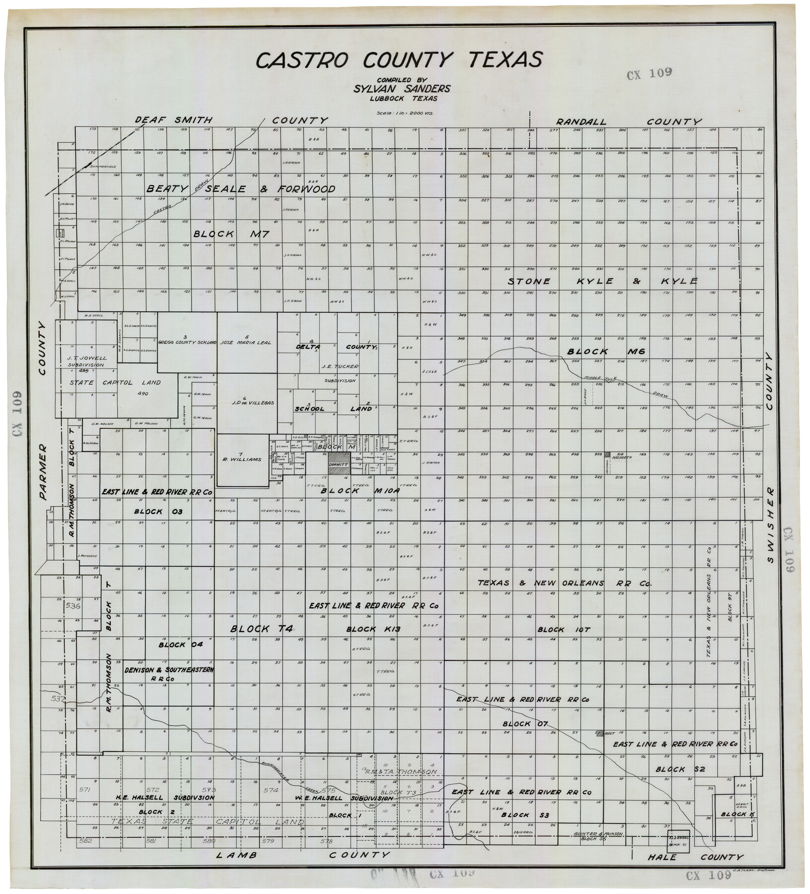
Castro County Texas
CX109
-
Map/Doc
92618
-
Collection
Twichell Survey Records
-
People and Organizations
Sylvan Sanders (Compiler)
C.A. Tubbs (Draftsman)
-
Counties
Castro
-
Subjects
County
-
Height x Width
34.0 x 37.5 inches
86.4 x 95.3 cm
Part of: Twichell Survey Records
Shamrock, Amended Plat on Section 44, Block 17, Wheeler County, Texas

Print $20.00
- Digital $50.00
Shamrock, Amended Plat on Section 44, Block 17, Wheeler County, Texas
Size 19.6 x 24.9 inches
Map/Doc 92132
General Highway Map, Hale County, Texas

Print $20.00
- Digital $50.00
General Highway Map, Hale County, Texas
1949
Size 18.8 x 25.9 inches
Map/Doc 92661

[B. S. & F. Blk. M10, D. & S. E. RR. Co. Secs. 138 thru 149]
![90133, [B. S. & F. Blk. M10, D. & S. E. RR. Co. Secs. 138 thru 149], Twichell Survey Records](https://historictexasmaps.com/wmedia_w700/maps/90133-1.tif.jpg)
Print $20.00
- Digital $50.00
[B. S. & F. Blk. M10, D. & S. E. RR. Co. Secs. 138 thru 149]
Size 26.4 x 15.5 inches
Map/Doc 90133
Conoco Official Road Map New Mexico

Print $20.00
- Digital $50.00
Conoco Official Road Map New Mexico
1934
Size 18.5 x 24.5 inches
Map/Doc 92437
[John Gibbs and surrounding surveys]
![91161, [John Gibbs and surrounding surveys], Twichell Survey Records](https://historictexasmaps.com/wmedia_w700/maps/91161-1.tif.jpg)
Print $20.00
- Digital $50.00
[John Gibbs and surrounding surveys]
Size 18.8 x 22.8 inches
Map/Doc 91161
Plat of Connecting Line between Northwest Corner of Eddy Sparks 1-1662

Print $20.00
- Digital $50.00
Plat of Connecting Line between Northwest Corner of Eddy Sparks 1-1662
1945
Size 20.0 x 27.6 inches
Map/Doc 92602
[Block O1, Godair]
![90564, [Block O1, Godair], Twichell Survey Records](https://historictexasmaps.com/wmedia_w700/maps/90564-1.tif.jpg)
Print $20.00
- Digital $50.00
[Block O1, Godair]
Size 21.7 x 14.1 inches
Map/Doc 90564
Yates Pool, Pecos County, Texas

Print $20.00
- Digital $50.00
Yates Pool, Pecos County, Texas
1920
Size 17.5 x 15.7 inches
Map/Doc 91564
[Surveys in the vicinity of Archer County School Land]
![90325, [Surveys in the vicinity of Archer County School Land], Twichell Survey Records](https://historictexasmaps.com/wmedia_w700/maps/90325-1.tif.jpg)
Print $20.00
- Digital $50.00
[Surveys in the vicinity of Archer County School Land]
Size 15.1 x 20.6 inches
Map/Doc 90325
Amarillo City Stock Yards

Print $20.00
- Digital $50.00
Amarillo City Stock Yards
Size 21.6 x 12.2 inches
Map/Doc 91745

You may also like
Hall County Sketch File 28

Print $20.00
- Digital $50.00
Hall County Sketch File 28
1913
Size 18.0 x 21.5 inches
Map/Doc 11611
Leon County Sketch File 10

Print $64.00
- Digital $50.00
Leon County Sketch File 10
1871
Size 10.6 x 15.7 inches
Map/Doc 29731
Flight Mission No. BQY-4M, Frame 31, Harris County

Print $20.00
- Digital $50.00
Flight Mission No. BQY-4M, Frame 31, Harris County
1953
Size 18.5 x 22.3 inches
Map/Doc 85246
Map of Blanco County

Print $20.00
- Digital $50.00
Map of Blanco County
1862
Size 28.1 x 18.7 inches
Map/Doc 3303
Palo Pinto County Working Sketch 2

Print $20.00
- Digital $50.00
Palo Pinto County Working Sketch 2
1906
Size 15.2 x 46.2 inches
Map/Doc 71385
Garza County Working Sketch 4

Print $20.00
- Digital $50.00
Garza County Working Sketch 4
1916
Size 19.5 x 23.1 inches
Map/Doc 63151
Flight Mission No. CLL-1N, Frame 76, Willacy County

Print $20.00
- Digital $50.00
Flight Mission No. CLL-1N, Frame 76, Willacy County
1954
Size 18.3 x 22.0 inches
Map/Doc 87022
Flight Mission No. DQO-8K, Frame 43, Galveston County

Print $20.00
- Digital $50.00
Flight Mission No. DQO-8K, Frame 43, Galveston County
1952
Size 18.6 x 22.3 inches
Map/Doc 85150
Ochiltree County Sketch File 12

Print $24.00
- Digital $50.00
Ochiltree County Sketch File 12
1990
Size 11.2 x 8.5 inches
Map/Doc 33201

Right of Way and Track Map Houston & Texas Central R.R. operated by the T. & N.O. R.R. Co., Austin Branch

Print $40.00
- Digital $50.00
Right of Way and Track Map Houston & Texas Central R.R. operated by the T. & N.O. R.R. Co., Austin Branch
1918
Size 25.5 x 57.7 inches
Map/Doc 64553
Gonzales County Sketch File 12

Print $4.00
- Digital $50.00
Gonzales County Sketch File 12
Size 10.8 x 8.7 inches
Map/Doc 24394