Aransas County NRC Article 33.136 Sketch 20
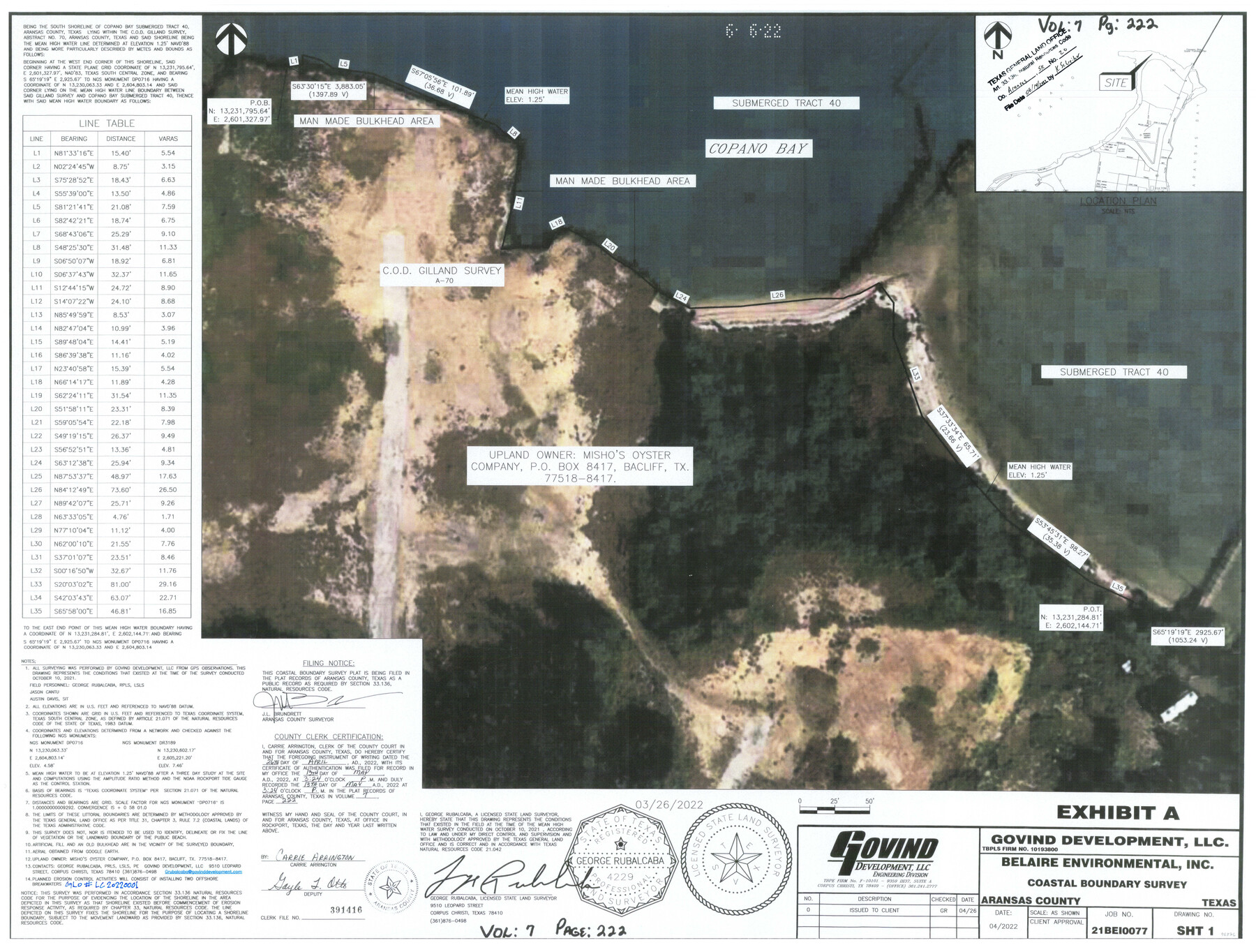
Coastal boundary survey delineating the south shoreline of Copano Bay Submerged Tract 40, Aransas County, Texas lying within the C.O.D. Gilland survey, abstract 70
-
Map/Doc
96876
-
Collection
General Map Collection
-
Object Dates
2022/6/14 (File Date)
2021/10/10 (Survey Date)
2022/3/26 (Creation Date)
-
People and Organizations
George Rubalcaba (Surveyor/Engineer)
Jason Cantu (Chainman/Field Personnel)
Austin Davis (Chainman/Field Personnel)
-
Counties
Aransas
-
Subjects
Surveying CBS
-
Medium
multi-page, multi-format
-
Comments
Project: Coastal boundary survey on the line of mean high water along Copano Bay Submerged Tract 40 and C.O.D. Gilland survey, abstract 70, Aransas County Project No.: Survey associated with GLO Project No. CL20220001 and USACE SWG 2021-00041
Part of: General Map Collection
Travis County Rolled Sketch 28

Print $20.00
- Digital $50.00
Travis County Rolled Sketch 28
1941
Size 22.7 x 27.0 inches
Map/Doc 8030
[Surveys in the Milam District on Bosque River and Spring Creek]
![3170, [Surveys in the Milam District on Bosque River and Spring Creek], General Map Collection](https://historictexasmaps.com/wmedia_w700/maps/3170.tif.jpg)
Print $20.00
- Digital $50.00
[Surveys in the Milam District on Bosque River and Spring Creek]
1846
Size 13.3 x 14.7 inches
Map/Doc 3170
Comanche County Sketch File 11

Print $4.00
- Digital $50.00
Comanche County Sketch File 11
Size 8.6 x 15.3 inches
Map/Doc 19072
Brazoria County Sketch File 1a

Print $6.00
- Digital $50.00
Brazoria County Sketch File 1a
1861
Size 12.5 x 11.5 inches
Map/Doc 14918
Flight Mission No. DCL-4C, Frame 65, Kenedy County

Print $20.00
- Digital $50.00
Flight Mission No. DCL-4C, Frame 65, Kenedy County
1943
Size 18.5 x 22.3 inches
Map/Doc 85810
Flight Mission No. CRK-8P, Frame 97, Refugio County

Print $20.00
- Digital $50.00
Flight Mission No. CRK-8P, Frame 97, Refugio County
1956
Size 18.5 x 22.1 inches
Map/Doc 86958
Shelby County Working Sketch 1

Print $20.00
- Digital $50.00
Shelby County Working Sketch 1
1917
Size 26.2 x 30.0 inches
Map/Doc 63854
Harbor of Brazos Santiago, Texas

Print $20.00
- Digital $50.00
Harbor of Brazos Santiago, Texas
1887
Size 27.1 x 18.3 inches
Map/Doc 72995
Midland County Working Sketch 14

Print $40.00
- Digital $50.00
Midland County Working Sketch 14
1953
Size 65.0 x 31.0 inches
Map/Doc 70994

Flight Mission No. BQY-4M, Frame 67, Harris County

Print $20.00
- Digital $50.00
Flight Mission No. BQY-4M, Frame 67, Harris County
1953
Size 18.7 x 22.4 inches
Map/Doc 85276
Galveston County NRC Article 33.136 Sketch 88

Print $42.00
- Digital $50.00
Galveston County NRC Article 33.136 Sketch 88
2019
Size 24.6 x 36.3 inches
Map/Doc 95735
You may also like
Flight Mission No. CRC-3R, Frame 100, Chambers County

Print $20.00
- Digital $50.00
Flight Mission No. CRC-3R, Frame 100, Chambers County
1956
Size 18.6 x 22.3 inches
Map/Doc 84838
Block D, Capitol Syndicate Subdivision of Portions of Capitol Land Reservation Leagues Number 333, 333 1/2, 336, and 345 1/2]
![91455, Block D, Capitol Syndicate Subdivision of Portions of Capitol Land Reservation Leagues Number 333, 333 1/2, 336, and 345 1/2], Twichell Survey Records](https://historictexasmaps.com/wmedia_w700/maps/91455-1.tif.jpg)
Print $20.00
- Digital $50.00
Block D, Capitol Syndicate Subdivision of Portions of Capitol Land Reservation Leagues Number 333, 333 1/2, 336, and 345 1/2]
Size 19.3 x 28.1 inches
Map/Doc 91455
La Salle County Boundary File 57b

Print $20.00
- Digital $50.00
La Salle County Boundary File 57b
Size 25.6 x 20.6 inches
Map/Doc 56258
[John P. Rohus and surrounding surveys]
![90974, [John P. Rohus and surrounding surveys], Twichell Survey Records](https://historictexasmaps.com/wmedia_w700/maps/90974-1.tif.jpg)
Print $20.00
- Digital $50.00
[John P. Rohus and surrounding surveys]
Size 26.1 x 19.9 inches
Map/Doc 90974
Presidio County Working Sketch 44

Print $20.00
- Digital $50.00
Presidio County Working Sketch 44
1949
Size 29.8 x 20.6 inches
Map/Doc 71721
Louisiana and Texas Intracoastal Waterway, Sabine River Galveston Bay Section Survey

Print $20.00
- Digital $50.00
Louisiana and Texas Intracoastal Waterway, Sabine River Galveston Bay Section Survey
1927
Size 30.7 x 43.0 inches
Map/Doc 61838
Dallam County Working Sketch 4

Print $20.00
- Digital $50.00
Dallam County Working Sketch 4
1974
Size 31.2 x 32.0 inches
Map/Doc 68589
Fractional Township No. 8 South Range No. 18 East of the Indian Meridian, Indian Territory

Print $20.00
- Digital $50.00
Fractional Township No. 8 South Range No. 18 East of the Indian Meridian, Indian Territory
1897
Size 19.2 x 24.3 inches
Map/Doc 75233
Map of Escarpment Section through Webb County, Texas (South half of Webb County)

Print $40.00
- Digital $50.00
Map of Escarpment Section through Webb County, Texas (South half of Webb County)
1925
Size 43.3 x 76.2 inches
Map/Doc 93163
Edwards County Rolled Sketch 20

Print $20.00
- Digital $50.00
Edwards County Rolled Sketch 20
1947
Size 31.6 x 40.4 inches
Map/Doc 8844
Howard County Working Sketch 4

Print $20.00
- Digital $50.00
Howard County Working Sketch 4
1940
Size 21.5 x 18.3 inches
Map/Doc 66270
Reeves County Rolled Sketch P

Print $20.00
- Digital $50.00
Reeves County Rolled Sketch P
Size 33.2 x 29.2 inches
Map/Doc 9847