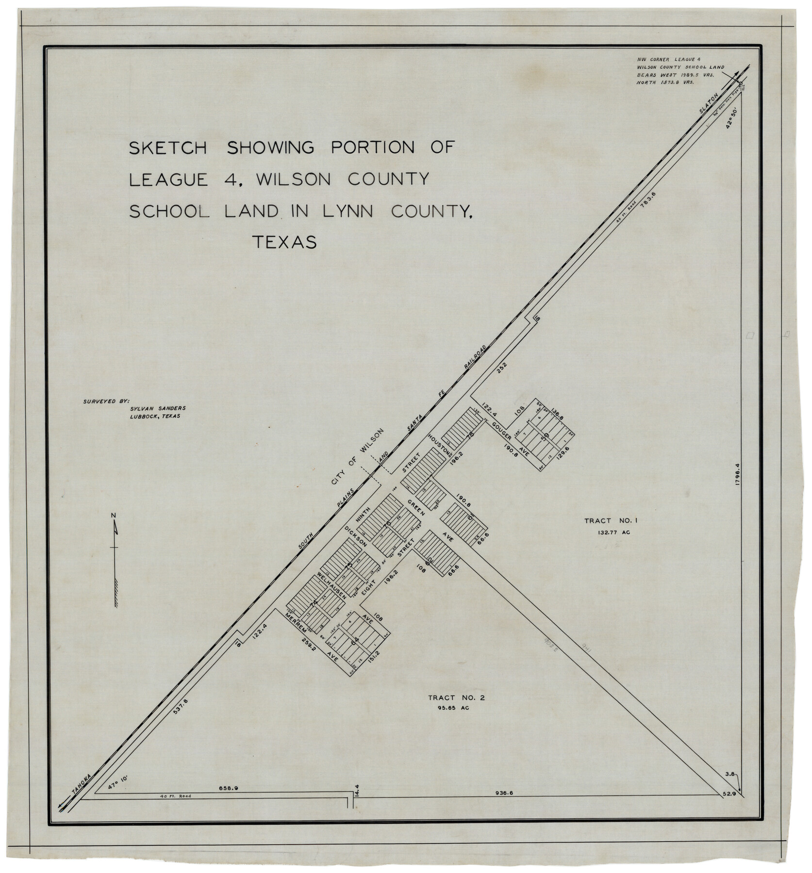
Sketch Showing Portion of League 4, Wilson County School Land in Lynn County
-
Map/Doc
92941
-
Collection
Twichell Survey Records
-
People and Organizations
Sylvan Sanders (Surveyor/Engineer)
-
Counties
Lynn
-
Height x Width
20.9 x 22.6 inches
53.1 x 57.4 cm
Part of: Twichell Survey Records
Map of Spearman Lands

Print $20.00
- Digital $50.00
Map of Spearman Lands
Size 20.4 x 15.6 inches
Map/Doc 90834
Working Sketch in Bastrop County

Print $20.00
- Digital $50.00
Working Sketch in Bastrop County
1923
Size 32.6 x 37.9 inches
Map/Doc 90147
W. D. Twichell's R. S. Hunnicutt's Resurvey in Oldham County, Texas June to November, 1915

Print $40.00
- Digital $50.00
W. D. Twichell's R. S. Hunnicutt's Resurvey in Oldham County, Texas June to November, 1915
1915
Size 71.3 x 42.6 inches
Map/Doc 89799
[Map showing J. H. Gibson Blocks D and DD and Double Lake Corner]
![92015, [Map showing J. H. Gibson Blocks D and DD and Double Lake Corner], Twichell Survey Records](https://historictexasmaps.com/wmedia_w700/maps/92015-1.tif.jpg)
Print $20.00
- Digital $50.00
[Map showing J. H. Gibson Blocks D and DD and Double Lake Corner]
Size 36.4 x 33.6 inches
Map/Doc 92015
Mrs. Alex A. Slaughter Ranch Hockley County, Texas

Print $20.00
- Digital $50.00
Mrs. Alex A. Slaughter Ranch Hockley County, Texas
Size 26.2 x 19.7 inches
Map/Doc 92237
Sketch Showing Portion of League 4, Wilson County School Land, Lynn County, Texas

Print $20.00
- Digital $50.00
Sketch Showing Portion of League 4, Wilson County School Land, Lynn County, Texas
Size 13.5 x 13.0 inches
Map/Doc 92940
[Central Portion of McMullen County]
![91301, [Central Portion of McMullen County], Twichell Survey Records](https://historictexasmaps.com/wmedia_w700/maps/91301-1.tif.jpg)
Print $20.00
- Digital $50.00
[Central Portion of McMullen County]
1884
Size 28.8 x 25.7 inches
Map/Doc 91301
University of Texas System University Lands

Print $20.00
- Digital $50.00
University of Texas System University Lands
1936
Size 23.1 x 17.5 inches
Map/Doc 93239
Sketch Showing Survey Base Lines of W. D. Twichell, State Surveyor as compiled from his Sketches "G", "J" and "M" and other record data filed in General Land Office from 1891 to 1915

Print $20.00
- Digital $50.00
Sketch Showing Survey Base Lines of W. D. Twichell, State Surveyor as compiled from his Sketches "G", "J" and "M" and other record data filed in General Land Office from 1891 to 1915
1915
Size 30.5 x 20.8 inches
Map/Doc 91999
[SE/4 of NW/4 of King Co.]
![89925, [SE/4 of NW/4 of King Co.], Twichell Survey Records](https://historictexasmaps.com/wmedia_w700/maps/89925-1.tif.jpg)
Print $40.00
- Digital $50.00
[SE/4 of NW/4 of King Co.]
Size 43.7 x 55.5 inches
Map/Doc 89925
"G" Sketch from Gaines County

Print $20.00
- Digital $50.00
"G" Sketch from Gaines County
1902
Size 31.7 x 21.7 inches
Map/Doc 90839
T. C. Ivey Ranch, Block D, Yoakum Co., Texas

Print $20.00
- Digital $50.00
T. C. Ivey Ranch, Block D, Yoakum Co., Texas
Size 17.1 x 14.6 inches
Map/Doc 91976
You may also like
Somervell Co.

Print $20.00
- Digital $50.00
Somervell Co.
1884
Size 28.0 x 26.8 inches
Map/Doc 63040
Map exhibiting the fixed location of the main trunk of the New-Orleans, Opelousas & Great Western Railroad of Louisiana…

Print $20.00
Map exhibiting the fixed location of the main trunk of the New-Orleans, Opelousas & Great Western Railroad of Louisiana…
1859
Size 25.2 x 37.0 inches
Map/Doc 93582
Matagorda Light to Aransas Pass

Print $20.00
- Digital $50.00
Matagorda Light to Aransas Pass
1974
Size 36.5 x 45.3 inches
Map/Doc 73401
Book of Photostatic Copies of Plats for Texas and Pacific Ry. Co. Lands

Digital $50.00
Book of Photostatic Copies of Plats for Texas and Pacific Ry. Co. Lands
Map/Doc 2222
Red River County Working Sketch 26

Print $20.00
- Digital $50.00
Red River County Working Sketch 26
1961
Size 30.9 x 31.6 inches
Map/Doc 72009
Approaches to Galveston Bay

Print $40.00
- Digital $50.00
Approaches to Galveston Bay
1982
Size 53.1 x 36.7 inches
Map/Doc 69884
No. 1 - Survey for a road from the Brazo Santiago to the Rio Grande

Print $20.00
- Digital $50.00
No. 1 - Survey for a road from the Brazo Santiago to the Rio Grande
1847
Size 18.3 x 27.2 inches
Map/Doc 72874
Navarro County Sketch File 13

Print $22.00
- Digital $50.00
Navarro County Sketch File 13
Size 12.0 x 8.6 inches
Map/Doc 32324
[Surveys in the Jefferson District]
![3177, [Surveys in the Jefferson District], General Map Collection](https://historictexasmaps.com/wmedia_w700/maps/3177.tif.jpg)
Print $2.00
- Digital $50.00
[Surveys in the Jefferson District]
1841
Size 9.8 x 8.0 inches
Map/Doc 3177
Crockett County Sketch File 99

Print $14.00
- Digital $50.00
Crockett County Sketch File 99
1925
Size 14.4 x 9.4 inches
Map/Doc 19980
Map of the Missouri, Kansas & Texas Railway and its connecting lines

Print $20.00
- Digital $50.00
Map of the Missouri, Kansas & Texas Railway and its connecting lines
1901
Size 16.3 x 9.1 inches
Map/Doc 95810
Lampasas County Boundary File 1

Print $4.00
- Digital $50.00
Lampasas County Boundary File 1
Size 10.2 x 8.2 inches
Map/Doc 56093