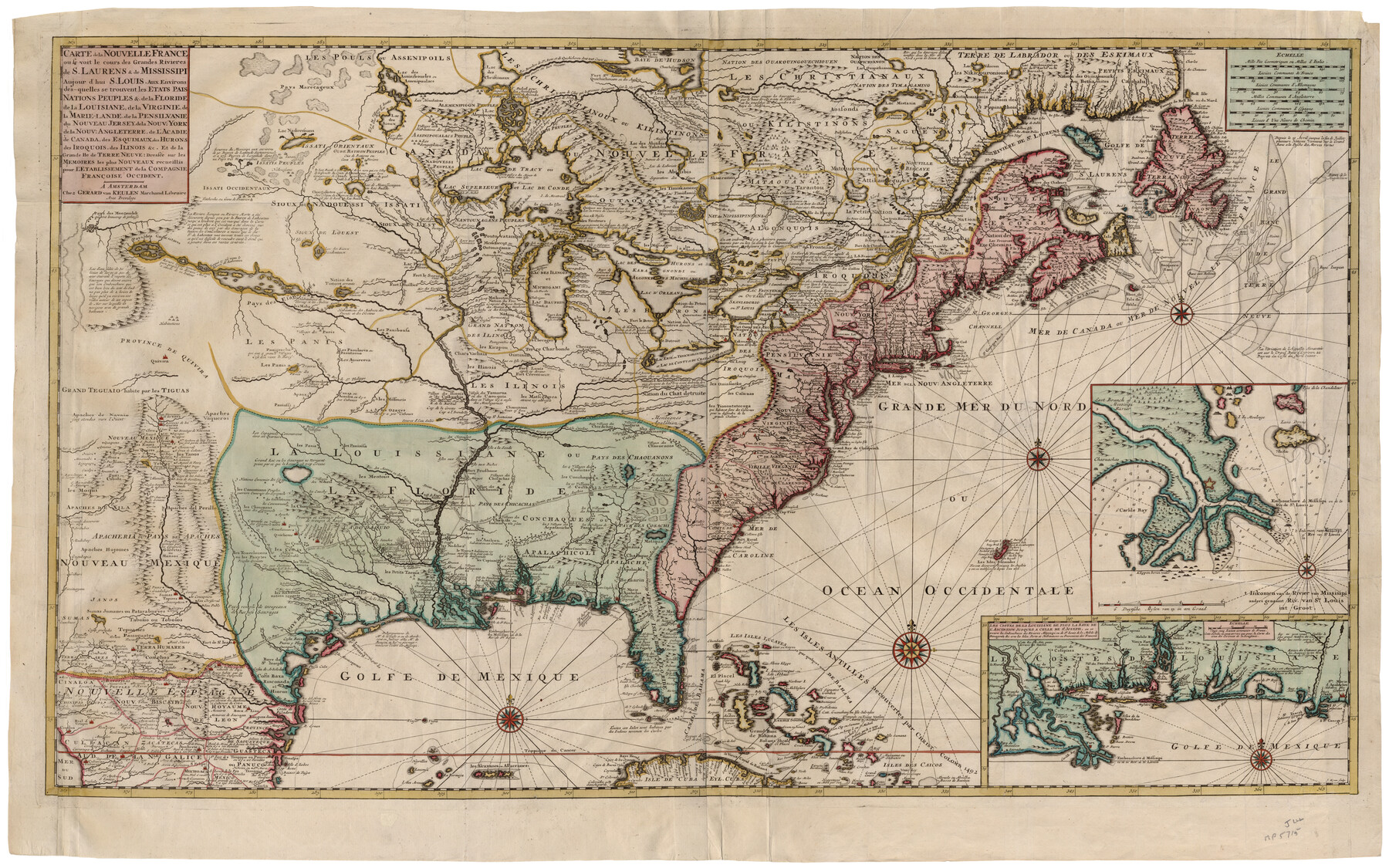
Carte de la Nouvelle France ou le voit le cours des Grandes Rivieres de S. Laurens & de Mississipi
-
Map/Doc
93822
-
Collection
Holcomb Digital Map Collection
-
Object Dates
1720 (Creation Date)
-
People and Organizations
Gerard Van Keulen (Author)
-
Subjects
North America
-
Height x Width
25.9 x 41.5 inches
65.8 x 105.4 cm
-
Comments
Courtesy of Frank and Carol Holcomb.
Part of: Holcomb Digital Map Collection
L'Amerique, divisée selon l[']etendue de ses principales parties, et dont les points principaux sont placez sur les observations de messieurs de l'Academie Royale des Sciences
![95688, L'Amerique, divisée selon l[']etendue de ses principales parties, et dont les points principaux sont placez sur les observations de messieurs de l'Academie Royale des Sciences, Holcomb Digital Map Collection](https://historictexasmaps.com/wmedia_w700/maps/95688.tif.jpg)
Print $40.00
- Digital $50.00
L'Amerique, divisée selon l[']etendue de ses principales parties, et dont les points principaux sont placez sur les observations de messieurs de l'Academie Royale des Sciences
1705
Size 44.9 x 65.4 inches
Map/Doc 95688
Texas (verso)

Print $20.00
- Digital $50.00
Texas (verso)
1833
Size 19.1 x 22.8 inches
Map/Doc 93837
Pressler's Map of the State of Texas

Print $40.00
- Digital $50.00
Pressler's Map of the State of Texas
1862
Size 48.0 x 52.7 inches
Map/Doc 95714
Il Disegno del discoperto della nova Franza, il quale se havuto ultimamente dalla novissima navigatione dè Francesi in quel luogo

Print $20.00
- Digital $50.00
Il Disegno del discoperto della nova Franza, il quale se havuto ultimamente dalla novissima navigatione dè Francesi in quel luogo
1566
Size 12.6 x 18.6 inches
Map/Doc 93804
Trace d'une partie Chemin de Fer de Galveston à Houston et Henderson, Texas, Etats unis d'Amérique

Print $20.00
- Digital $50.00
Trace d'une partie Chemin de Fer de Galveston à Houston et Henderson, Texas, Etats unis d'Amérique
1857
Size 17.1 x 21.8 inches
Map/Doc 93905
Americae Sive Novi Orbis Nova Descriptio

Print $20.00
- Digital $50.00
Americae Sive Novi Orbis Nova Descriptio
1606
Size 16.5 x 22.4 inches
Map/Doc 93810
J. De Cordova's Map of the State of Texas Compiled from the records of the General Land Office of the State

Print $2.00
- Digital $50.00
J. De Cordova's Map of the State of Texas Compiled from the records of the General Land Office of the State
1855
Size 6.8 x 4.0 inches
Map/Doc 93912
Map of Texas and the Countries Adjacent compiled in the Bureau of the Corps of Topographical Engineers from the Best Authorities

Print $2.00
- Digital $50.00
Map of Texas and the Countries Adjacent compiled in the Bureau of the Corps of Topographical Engineers from the Best Authorities
1844
Size 8.1 x 5.0 inches
Map/Doc 93868
A Map of Louisiana and Mexico

Print $20.00
- Digital $50.00
A Map of Louisiana and Mexico
1820
Size 43.8 x 32.9 inches
Map/Doc 94945
Americae nova Tabula

Print $20.00
- Digital $50.00
Americae nova Tabula
1635
Size 18.4 x 24.3 inches
Map/Doc 93812
Carte de la Nouvelle France ou le voit le cours des Grandes Rivieres de S. Laurens & de Mississipi

Print $20.00
- Digital $50.00
Carte de la Nouvelle France ou le voit le cours des Grandes Rivieres de S. Laurens & de Mississipi
1720
Size 25.9 x 41.5 inches
Map/Doc 93822
A New and Correct Map of North America, with the West India Islands

Print $20.00
- Digital $50.00
A New and Correct Map of North America, with the West India Islands
1784
Size 44.0 x 52.2 inches
Map/Doc 93828
You may also like
Kendall County Sketch File 7

Print $4.00
- Digital $50.00
Kendall County Sketch File 7
1848
Size 8.2 x 10.4 inches
Map/Doc 28688
Culberson County Rolled Sketch 50

Print $20.00
- Digital $50.00
Culberson County Rolled Sketch 50
1963
Size 19.3 x 25.0 inches
Map/Doc 5669
Montgomery Co.

Print $40.00
- Digital $50.00
Montgomery Co.
1943
Size 45.1 x 53.3 inches
Map/Doc 66940
Bailey County Rolled Sketch 2

Print $20.00
- Digital $50.00
Bailey County Rolled Sketch 2
1913
Size 26.8 x 21.4 inches
Map/Doc 5109
Motley County Working Sketch 3

Print $20.00
- Digital $50.00
Motley County Working Sketch 3
1914
Size 13.2 x 20.4 inches
Map/Doc 71208
Tarrant County Sketch File 33

Print $48.00
- Digital $50.00
Tarrant County Sketch File 33
1954
Size 11.6 x 8.8 inches
Map/Doc 37759
Flight Mission No. DCL-7C, Frame 146, Kenedy County

Print $20.00
- Digital $50.00
Flight Mission No. DCL-7C, Frame 146, Kenedy County
1943
Size 18.8 x 22.4 inches
Map/Doc 86103
Coryelle County

Print $20.00
- Digital $50.00
Coryelle County
1855
Size 18.6 x 23.1 inches
Map/Doc 51904
Sulphur River, Talco Sheet

Print $20.00
- Digital $50.00
Sulphur River, Talco Sheet
1917
Size 12.5 x 25.5 inches
Map/Doc 78336
Andrews County

Print $40.00
- Digital $50.00
Andrews County
1951
Size 43.0 x 54.4 inches
Map/Doc 77199
San Jacinto County Rolled Sketch 12

Print $20.00
- Digital $50.00
San Jacinto County Rolled Sketch 12
1948
Size 24.2 x 32.5 inches
Map/Doc 7561
[Capitol Leagues along Bailey-Lamb County Line]
![89630, [Capitol Leagues along Bailey-Lamb County Line], Twichell Survey Records](https://historictexasmaps.com/wmedia_w700/maps/89630-1.tif.jpg)
Print $40.00
- Digital $50.00
[Capitol Leagues along Bailey-Lamb County Line]
Size 12.6 x 49.5 inches
Map/Doc 89630