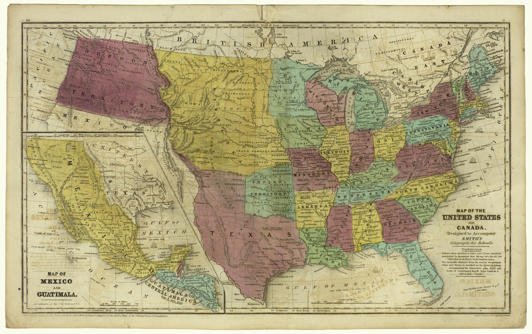
Map of the United States and Canada designed to accompany Smith's Geography for Schools
[Inset:] Map of Mexico and Guatimala
-
Map/Doc
93884
-
Collection
Holcomb Digital Map Collection
-
Object Dates
1850 (Creation Date)
-
People and Organizations
Stiles, Sherman and Smith (Printer)
Stiles, Sherman and Smith (Draftsman)
-
Subjects
Mexico United States
-
Height x Width
12.1 x 19.2 inches
30.7 x 48.8 cm
-
Comments
Courtesy of Frank and Carol Holcomb.
Part of: Holcomb Digital Map Collection
The North Part of America

Print $20.00
- Digital $50.00
The North Part of America
1625
Size 13.1 x 14.8 inches
Map/Doc 93815
J. De Cordova's Map of the State of Texas Compiled from the records of the General Land Office of the State

Print $20.00
- Digital $50.00
J. De Cordova's Map of the State of Texas Compiled from the records of the General Land Office of the State
1849
Size 33.7 x 36.1 inches
Map/Doc 94026
A new & correct map of Texas compiled from the most recent surveys & authorities to the year 1845

Print $20.00
- Digital $50.00
A new & correct map of Texas compiled from the most recent surveys & authorities to the year 1845
1845
Size 22.4 x 28.5 inches
Map/Doc 96973
Topographisch-geognostische Karte von Texas mit Zugrundelegung der geographischen Karte v. Wilson nach eigenen Beobachtungen bearbeitet von Dr. Ferd. Roemer

Print $20.00
- Digital $50.00
Topographisch-geognostische Karte von Texas mit Zugrundelegung der geographischen Karte v. Wilson nach eigenen Beobachtungen bearbeitet von Dr. Ferd. Roemer
1849
Size 24.5 x 21.0 inches
Map/Doc 94099
Brady's Glimpses of Texas with maps

Print $216.00
- Digital $50.00
Brady's Glimpses of Texas with maps
1871
Size 7.5 x 4.9 inches
Map/Doc 93918
North America and the West Indies

Print $20.00
- Digital $50.00
North America and the West Indies
1763
Size 41.6 x 46.9 inches
Map/Doc 93834
A New Map of Texas, Oregon and California with the regions adjoining, compiled from the most recent authorities

Print $20.00
- Digital $50.00
A New Map of Texas, Oregon and California with the regions adjoining, compiled from the most recent authorities
1846
Size 23.2 x 21.2 inches
Map/Doc 93872
Map of the British Isles designed to accompany Smith's Geography for Schools

Print $20.00
- Digital $50.00
Map of the British Isles designed to accompany Smith's Geography for Schools
1850
Size 12.1 x 9.8 inches
Map/Doc 93894
L'Amerique, divisée selon l[']etendue de ses principales parties, et dont les points principaux sont placez sur les observations de messieurs de l'Academie Royale des Sciences
![95688, L'Amerique, divisée selon l[']etendue de ses principales parties, et dont les points principaux sont placez sur les observations de messieurs de l'Academie Royale des Sciences, Holcomb Digital Map Collection](https://historictexasmaps.com/wmedia_w700/maps/95688.tif.jpg)
Print $40.00
- Digital $50.00
L'Amerique, divisée selon l[']etendue de ses principales parties, et dont les points principaux sont placez sur les observations de messieurs de l'Academie Royale des Sciences
1705
Size 44.9 x 65.4 inches
Map/Doc 95688
A Visit to Texas: Being The Journal of a Traveler Through Those Parts Most Interesting to American Settlers. With Descriptions of Scenery, Habits, & c. &c.

Print $560.00
- Digital $50.00
A Visit to Texas: Being The Journal of a Traveler Through Those Parts Most Interesting to American Settlers. With Descriptions of Scenery, Habits, & c. &c.
1834
Size 8.0 x 5.2 inches
Map/Doc 93849
Map of the State of Texas from the Latest Authorities

Print $20.00
- Digital $50.00
Map of the State of Texas from the Latest Authorities
1854
Size 13.1 x 16.1 inches
Map/Doc 93901
Map of the Middle States designed to accompany Smith's Geography for Schools

Print $20.00
- Digital $50.00
Map of the Middle States designed to accompany Smith's Geography for Schools
1850
Size 19.4 x 12.2 inches
Map/Doc 93887
You may also like
Howard County Working Sketch 5

Print $20.00
- Digital $50.00
Howard County Working Sketch 5
1944
Size 23.9 x 32.8 inches
Map/Doc 66271
Brewster County Rolled Sketch 145

Print $20.00
- Digital $50.00
Brewster County Rolled Sketch 145
1944
Size 24.1 x 18.5 inches
Map/Doc 5312
Uvalde County Working Sketch 12

Print $20.00
- Digital $50.00
Uvalde County Working Sketch 12
1943
Size 28.5 x 27.4 inches
Map/Doc 72082
General Highway Map, Medina County, Texas

Print $20.00
General Highway Map, Medina County, Texas
1940
Size 18.3 x 24.5 inches
Map/Doc 79194
Chambers County Boundary File 1

Print $28.00
- Digital $50.00
Chambers County Boundary File 1
Size 8.9 x 6.7 inches
Map/Doc 51226
Nueces County Rolled Sketch 113B

Print $20.00
- Digital $50.00
Nueces County Rolled Sketch 113B
1972
Size 18.6 x 24.2 inches
Map/Doc 7123
Smith County Working Sketch 1

Print $20.00
- Digital $50.00
Smith County Working Sketch 1
Size 16.3 x 13.0 inches
Map/Doc 63886
Hardin County Sketch File 61

Print $20.00
- Digital $50.00
Hardin County Sketch File 61
1933
Size 18.9 x 24.6 inches
Map/Doc 11636
[Right of Way & Track Map, The Texas & Pacific Ry. Co. Main Line]
![64672, [Right of Way & Track Map, The Texas & Pacific Ry. Co. Main Line], General Map Collection](https://historictexasmaps.com/wmedia_w700/maps/64672.tif.jpg)
Print $20.00
- Digital $50.00
[Right of Way & Track Map, The Texas & Pacific Ry. Co. Main Line]
Size 11.0 x 18.4 inches
Map/Doc 64672
Crockett County Rolled Sketch 88M

Print $20.00
- Digital $50.00
Crockett County Rolled Sketch 88M
1964
Size 25.2 x 34.2 inches
Map/Doc 5629
Flight Mission No. BQR-5K, Frame 70, Brazoria County

Print $20.00
- Digital $50.00
Flight Mission No. BQR-5K, Frame 70, Brazoria County
1952
Size 18.8 x 22.4 inches
Map/Doc 84015
Van Zandt County Rolled Sketch 6

Print $3.00
- Digital $50.00
Van Zandt County Rolled Sketch 6
1946
Size 9.3 x 11.3 inches
Map/Doc 10311