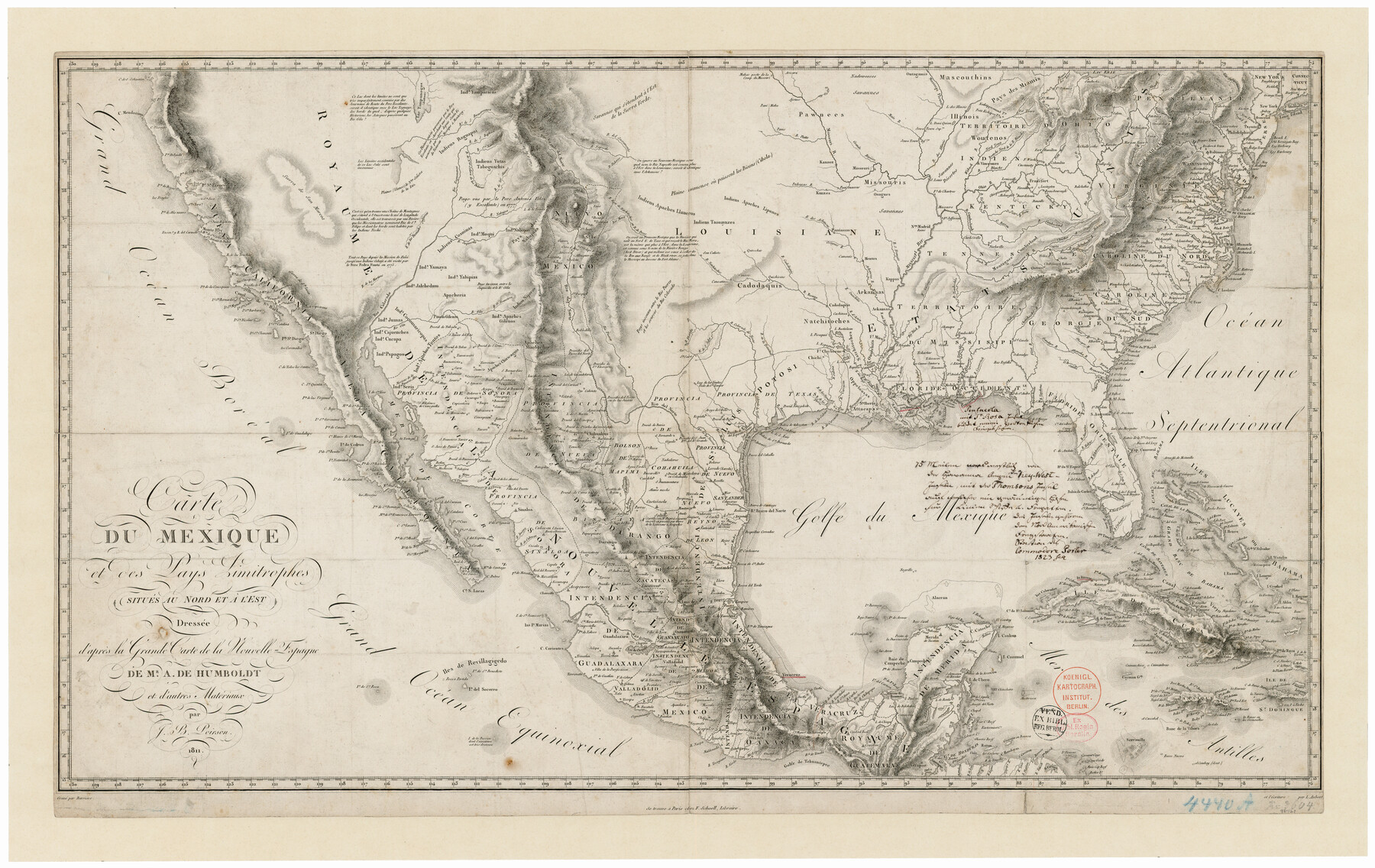
Carte du Mexique et des Pays Limitrophes Situés au Nord et à l'Est
[Translation: Map of Mexico and Countries to the North and East]
-
Map/Doc
93421
-
Collection
General Map Collection
-
Object Dates
1811 (Creation Date)
2013/3/4 (File Date)
-
People and Organizations
F. Schoell (Publisher)
Barriere (Printer)
Alexander von Humboldt (Author)
Jean Baptiste Poirson (Draftsman)
-
Subjects
Mexico North America Spanish Texas
-
Height x Width
17.5 x 29.0 inches
44.5 x 73.7 cm
-
Comments
Shows the presidios "Bejar" and "la Bahia" within province of Texas. Many subsequent maps such as those by Pike and Arrowsmith based their efforts and built upon the info shown on this map.
-
URLs
https://medium.com/save-texas-history/carte-du-mexique-et-des-pays-limitrophes-par-j-b-poirson-1811-cdba77641ffd#.v3mqawnnu
Part of: General Map Collection
Matagorda Bay and Approaches

Print $20.00
- Digital $50.00
Matagorda Bay and Approaches
1989
Size 36.3 x 45.0 inches
Map/Doc 73389
McMullen County Sketch File 5

Print $4.00
- Digital $50.00
McMullen County Sketch File 5
1854
Size 8.7 x 8.3 inches
Map/Doc 31343
Tourist Map of San Antonio showing points of interest, places of amusements, main thoroughfares and highways in and out of city and where they go

Print $20.00
- Digital $50.00
Tourist Map of San Antonio showing points of interest, places of amusements, main thoroughfares and highways in and out of city and where they go
Size 22.2 x 15.3 inches
Map/Doc 95956
Uvalde County Working Sketch 14

Print $20.00
- Digital $50.00
Uvalde County Working Sketch 14
1943
Size 13.5 x 16.0 inches
Map/Doc 72084
[Pacific & Santa Fe Railroad through Fort Stockton]
![64770, [Pacific & Santa Fe Railroad through Fort Stockton], General Map Collection](https://historictexasmaps.com/wmedia_w700/maps/64770.tif.jpg)
Print $20.00
- Digital $50.00
[Pacific & Santa Fe Railroad through Fort Stockton]
Size 18.4 x 20.5 inches
Map/Doc 64770
Culberson County Rolled Sketch 52

Print $20.00
- Digital $50.00
Culberson County Rolled Sketch 52
1966
Size 19.1 x 24.9 inches
Map/Doc 5671
Karnes County Rolled Sketch 3A

Print $20.00
- Digital $50.00
Karnes County Rolled Sketch 3A
1959
Size 23.9 x 28.6 inches
Map/Doc 6455
[The S.K. Ry. of Texas, State Line to Pecos, Reeves Co., Texas]
![64159, [The S.K. Ry. of Texas, State Line to Pecos, Reeves Co., Texas], General Map Collection](https://historictexasmaps.com/wmedia_w700/maps/64159.tif.jpg)
Print $40.00
- Digital $50.00
[The S.K. Ry. of Texas, State Line to Pecos, Reeves Co., Texas]
1910
Size 19.4 x 130.6 inches
Map/Doc 64159
Harris County Boundary File 39 (14)

Print $30.00
- Digital $50.00
Harris County Boundary File 39 (14)
Size 13.2 x 8.1 inches
Map/Doc 54344
Haskell County Working Sketch 7

Print $40.00
- Digital $50.00
Haskell County Working Sketch 7
1956
Size 52.1 x 39.0 inches
Map/Doc 66065
Kimble County Working Sketch 95

Print $20.00
- Digital $50.00
Kimble County Working Sketch 95
1994
Size 36.2 x 45.9 inches
Map/Doc 70163

You may also like
Signal Hill Texas

Print $20.00
- Digital $50.00
Signal Hill Texas
Size 17.5 x 17.7 inches
Map/Doc 92112
Montgomery County Sketch File 21

Print $8.00
- Digital $50.00
Montgomery County Sketch File 21
1934
Size 9.0 x 13.2 inches
Map/Doc 31856

Flight Mission No. DAG-17K, Frame 65, Matagorda County

Print $20.00
- Digital $50.00
Flight Mission No. DAG-17K, Frame 65, Matagorda County
1952
Size 17.5 x 16.1 inches
Map/Doc 86327
Liberty County Working Sketch 16

Print $20.00
- Digital $50.00
Liberty County Working Sketch 16
1936
Size 24.1 x 34.7 inches
Map/Doc 70475
Webb County Working Sketch 13

Print $20.00
- Digital $50.00
Webb County Working Sketch 13
1922
Size 14.6 x 11.4 inches
Map/Doc 72378
Hudspeth County Rolled Sketch 46

Print $40.00
- Digital $50.00
Hudspeth County Rolled Sketch 46
Size 10.2 x 128.3 inches
Map/Doc 76039
E. R. Allen Irrigated Farm SE Quarter Section 21, Block E

Print $3.00
- Digital $50.00
E. R. Allen Irrigated Farm SE Quarter Section 21, Block E
Size 10.3 x 14.3 inches
Map/Doc 92319
Right of Way and Track Map International & Gt Northern Ry. operated by the International & Gt. Northern Ry. Co., San Antonio Division

Print $40.00
- Digital $50.00
Right of Way and Track Map International & Gt Northern Ry. operated by the International & Gt. Northern Ry. Co., San Antonio Division
1917
Size 25.6 x 58.1 inches
Map/Doc 64587
Upton County Rolled Sketch 2

Print $20.00
- Digital $50.00
Upton County Rolled Sketch 2
1884
Size 26.2 x 36.1 inches
Map/Doc 8065
Travis County Sketch File 41

Print $22.00
- Digital $50.00
Travis County Sketch File 41
1928
Size 11.7 x 30.2 inches
Map/Doc 12465
Montgomery County Rolled Sketch 10A
Print $20.00
- Digital $50.00
Montgomery County Rolled Sketch 10A
Size 12.1 x 18.1 inches
Map/Doc 6800