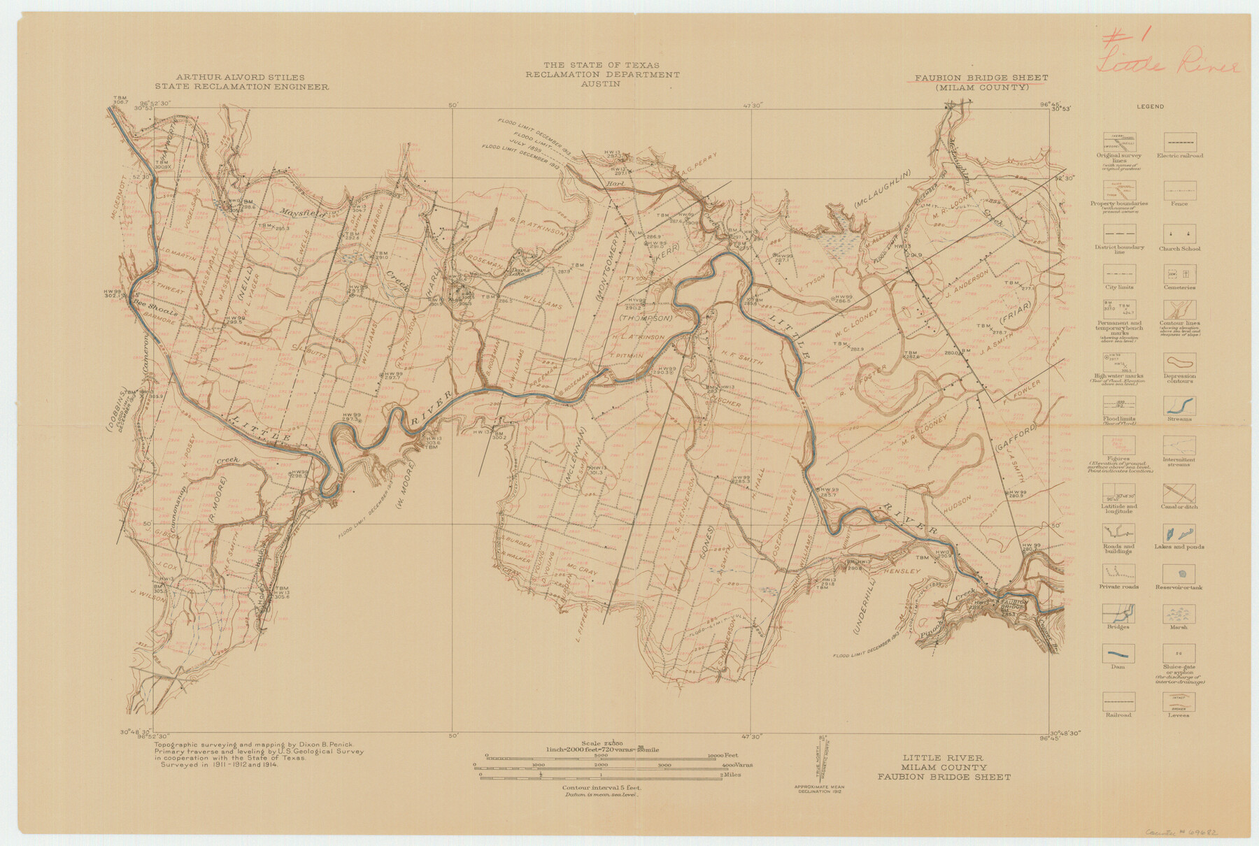
Little River, Faubion Bridge Sheet
-
Map/Doc
69682
-
Collection
General Map Collection
-
Object Dates
1914 (Creation Date)
-
People and Organizations
Texas State Reclamation Department (Publisher)
Dixon B. Penick (Surveyor/Engineer)
-
Counties
Milam
-
Subjects
River Surveys Topographic
-
Height x Width
18.5 x 27.6 inches
47.0 x 70.1 cm
-
Comments
Little River is formed by the union of the Leon River and the Lampasas River. It then flows southeasterly into the Brazos River.
Part of: General Map Collection
Briscoe County Sketch File H-1

Print $40.00
- Digital $50.00
Briscoe County Sketch File H-1
Size 21.7 x 18.2 inches
Map/Doc 11006
Goliad County Working Sketch 8

Print $20.00
- Digital $50.00
Goliad County Working Sketch 8
1937
Size 29.7 x 36.0 inches
Map/Doc 63198
Nueces County Rolled Sketch 70

Print $60.00
Nueces County Rolled Sketch 70
1980
Size 25.3 x 38.0 inches
Map/Doc 6921
Harris County Historic Topographic 13

Print $20.00
- Digital $50.00
Harris County Historic Topographic 13
1915
Size 29.1 x 22.6 inches
Map/Doc 65823
Harris County Working Sketch 48

Print $20.00
- Digital $50.00
Harris County Working Sketch 48
1943
Size 26.8 x 16.0 inches
Map/Doc 65940
Armstrong County Sketch File A-4

Print $40.00
- Digital $50.00
Armstrong County Sketch File A-4
Size 14.8 x 20.5 inches
Map/Doc 10845
Rusk County Rolled Sketch 7

Print $20.00
- Digital $50.00
Rusk County Rolled Sketch 7
Size 43.0 x 37.3 inches
Map/Doc 9876
Newton County Working Sketch 7

Print $20.00
- Digital $50.00
Newton County Working Sketch 7
1936
Size 32.3 x 37.0 inches
Map/Doc 71253
Crane County Sketch File 28

Print $6.00
- Digital $50.00
Crane County Sketch File 28
1953
Size 11.5 x 9.1 inches
Map/Doc 19605
Presidio County Working Sketch 23

Print $20.00
- Digital $50.00
Presidio County Working Sketch 23
1945
Size 35.7 x 23.3 inches
Map/Doc 71699
Collin County Rolled Sketch 1

Print $20.00
- Digital $50.00
Collin County Rolled Sketch 1
1953
Size 34.9 x 35.6 inches
Map/Doc 8635
Baylor County Rolled Sketch 11

Print $20.00
- Digital $50.00
Baylor County Rolled Sketch 11
Size 19.4 x 19.9 inches
Map/Doc 5128
You may also like
[Location St. L. & S. W. R. R. Through Cherokee County]
![64044, [Location St. L. & S. W. R. R. Through Cherokee County], General Map Collection](https://historictexasmaps.com/wmedia_w700/maps/64044-1.tif.jpg)
Print $40.00
- Digital $50.00
[Location St. L. & S. W. R. R. Through Cherokee County]
Size 39.2 x 122.1 inches
Map/Doc 64044
Jack County Sketch File 37

Print $4.00
- Digital $50.00
Jack County Sketch File 37
1963
Size 3.5 x 7.6 inches
Map/Doc 27615
Leon County Sketch File 10

Print $64.00
- Digital $50.00
Leon County Sketch File 10
1871
Size 10.6 x 15.7 inches
Map/Doc 29731
[William Steele Survey near Copano Bay]
![60285, [William Steele Survey near Copano Bay], General Map Collection](https://historictexasmaps.com/wmedia_w700/maps/60285-1.tif.jpg)
Print $3.00
- Digital $50.00
[William Steele Survey near Copano Bay]
1927
Size 14.9 x 9.8 inches
Map/Doc 60285
State Highway System of Texas Showing Condition of Improvement

Print $20.00
- Digital $50.00
State Highway System of Texas Showing Condition of Improvement
1928
Size 24.3 x 36.4 inches
Map/Doc 93719
[Corpus Christi Bay, Padre Island, Mustang Island, Laguna de la Madre, King and Kenedy's Pasture]
![73041, [Corpus Christi Bay, Padre Island, Mustang Island, Laguna de la Madre, King and Kenedy's Pasture], General Map Collection](https://historictexasmaps.com/wmedia_w700/maps/73041.tif.jpg)
Print $20.00
- Digital $50.00
[Corpus Christi Bay, Padre Island, Mustang Island, Laguna de la Madre, King and Kenedy's Pasture]
Size 26.2 x 18.1 inches
Map/Doc 73041
Reagan County Working Sketch 29

Print $40.00
- Digital $50.00
Reagan County Working Sketch 29
1963
Size 34.3 x 66.4 inches
Map/Doc 71871
San Augustine County Sketch File 20

Print $82.00
- Digital $50.00
San Augustine County Sketch File 20
1951
Size 8.9 x 14.4 inches
Map/Doc 35680
Map of Concho County

Print $20.00
- Digital $50.00
Map of Concho County
1879
Size 23.4 x 18.3 inches
Map/Doc 4523
Nueces County Rolled Sketch 24

Print $20.00
- Digital $50.00
Nueces County Rolled Sketch 24
Size 19.6 x 24.8 inches
Map/Doc 6873
General Highway Map Cochran County, Texas

Print $20.00
- Digital $50.00
General Highway Map Cochran County, Texas
1948
Size 18.7 x 25.6 inches
Map/Doc 92498
Atascosa County Rolled Sketch 19

Print $20.00
- Digital $50.00
Atascosa County Rolled Sketch 19
1955
Size 22.1 x 18.3 inches
Map/Doc 5099