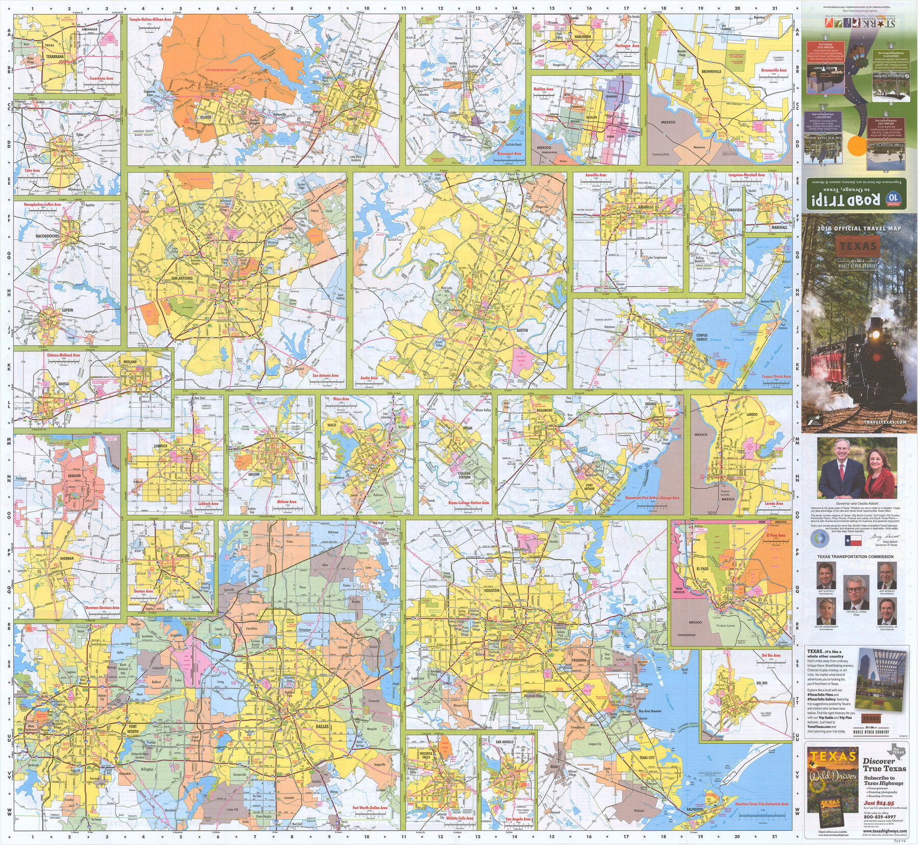
2016 Official Travel Map, Texas
[Recto - Map of Various Texas Cities]
-
Map/Doc
94297
-
Collection
General Map Collection
-
Object Dates
2016 (Edition Date)
-
People and Organizations
Texas Department of Transportation (Publisher)
Mark Lambert (Donor)
-
Subjects
City
-
Height x Width
33.3 x 36.2 inches
84.6 x 92.0 cm
-
Medium
paper, etching/engraving/lithograph
-
Comments
Donated by Mark Lambert. For map of Texas on verso see 94298. For reseach purposes only.
Related maps
2016 Official Travel Map, Texas

2016 Official Travel Map, Texas
Size 33.3 x 36.2 inches
Map/Doc 94298
Part of: General Map Collection
Flight Mission No. BRE-2P, Frame 95, Nueces County

Print $20.00
- Digital $50.00
Flight Mission No. BRE-2P, Frame 95, Nueces County
1956
Size 18.4 x 22.3 inches
Map/Doc 86780
Limestone County Sketch File 24

Print $8.00
- Digital $50.00
Limestone County Sketch File 24
1942
Size 11.2 x 8.8 inches
Map/Doc 30206
Goliad County Working Sketch 16

Print $20.00
- Digital $50.00
Goliad County Working Sketch 16
1949
Size 30.0 x 46.9 inches
Map/Doc 63206
Map of San Antonio, Texas, Postal Delivery Units showing all boundary lines / Tourist Map of San Antonio showing points of interest and places of amusements, main thoroughfares and highways in and out of city and where they go / Business Section Map

Map of San Antonio, Texas, Postal Delivery Units showing all boundary lines / Tourist Map of San Antonio showing points of interest and places of amusements, main thoroughfares and highways in and out of city and where they go / Business Section Map
Size 18.0 x 24.0 inches
Map/Doc 95160
Aransas County Sketch File 29

Print $24.00
- Digital $50.00
Aransas County Sketch File 29
Size 7.8 x 8.1 inches
Map/Doc 13234
Map of Webb County

Print $20.00
- Digital $50.00
Map of Webb County
1888
Size 33.6 x 27.7 inches
Map/Doc 4128
Wheeler County Working Sketch 4

Print $40.00
- Digital $50.00
Wheeler County Working Sketch 4
1972
Size 58.9 x 47.1 inches
Map/Doc 72493
Garza County Working Sketch 6

Print $20.00
- Digital $50.00
Garza County Working Sketch 6
1944
Size 24.8 x 20.2 inches
Map/Doc 63153
Hall County Sketch File 33

Print $16.00
- Digital $50.00
Hall County Sketch File 33
1912
Size 11.4 x 8.7 inches
Map/Doc 24874
Hutchinson County Sketch File 1

Print $22.00
- Digital $50.00
Hutchinson County Sketch File 1
Size 8.9 x 7.8 inches
Map/Doc 27172
Flight Mission No. CGI-1N, Frame 214, Cameron County

Print $20.00
- Digital $50.00
Flight Mission No. CGI-1N, Frame 214, Cameron County
1955
Size 18.5 x 22.1 inches
Map/Doc 84523
Newton County Sketch File 27

Print $4.00
- Digital $50.00
Newton County Sketch File 27
Size 13.0 x 8.6 inches
Map/Doc 32411
You may also like
Wichita County Working Sketch 20

Print $20.00
- Digital $50.00
Wichita County Working Sketch 20
1950
Size 33.2 x 23.0 inches
Map/Doc 72530
[Sketch for Mineral Application 35811 - Liberty County, John Mecom]
![65620, [Sketch for Mineral Application 35811 - Liberty County, John Mecom], General Map Collection](https://historictexasmaps.com/wmedia_w700/maps/65620.tif.jpg)
Print $4.00
- Digital $50.00
[Sketch for Mineral Application 35811 - Liberty County, John Mecom]
1941
Size 24.8 x 19.7 inches
Map/Doc 65620
Mitchell County Rolled Sketch 2A

Print $20.00
- Digital $50.00
Mitchell County Rolled Sketch 2A
Size 24.2 x 18.6 inches
Map/Doc 7954
Sterling County Rolled Sketch 13

Print $20.00
- Digital $50.00
Sterling County Rolled Sketch 13
1945
Size 34.9 x 27.3 inches
Map/Doc 7847
Maps of Gulf Intracoastal Waterway, Texas - Sabine River to the Rio Grande and connecting waterways including ship channels

Print $20.00
- Digital $50.00
Maps of Gulf Intracoastal Waterway, Texas - Sabine River to the Rio Grande and connecting waterways including ship channels
1966
Size 14.6 x 22.3 inches
Map/Doc 61950
Harris County Rolled Sketch 81

Print $28.00
- Digital $50.00
Harris County Rolled Sketch 81
1956
Size 31.1 x 22.2 inches
Map/Doc 6117
Map of the State of Louisiana engraved for Mitchell's new intermediate geography, Louisiana Edition (Inset: Vicinity of New Orleans)

Print $20.00
- Digital $50.00
Map of the State of Louisiana engraved for Mitchell's new intermediate geography, Louisiana Edition (Inset: Vicinity of New Orleans)
1885
Size 9.0 x 12.2 inches
Map/Doc 93533
The City of Austin and Suburbs

Print $20.00
The City of Austin and Suburbs
1919
Size 24.1 x 19.1 inches
Map/Doc 76203
General Highway Map, Kimble County, Texas

Print $20.00
General Highway Map, Kimble County, Texas
1961
Size 24.6 x 18.2 inches
Map/Doc 79553
Texas Coast Country on the Southern Pacific Lines

Texas Coast Country on the Southern Pacific Lines
1917
Size 9.4 x 6.4 inches
Map/Doc 97061
Jefferson County Sketch File 33

Print $32.00
- Digital $50.00
Jefferson County Sketch File 33
1934
Size 8.2 x 7.6 inches
Map/Doc 28197
A. H. Baer Estate

Print $20.00
- Digital $50.00
A. H. Baer Estate
Size 18.4 x 15.6 inches
Map/Doc 92748